- Home
- About
- Map
- Trips
- Bringing Boat West
- Migration West
- Solo Motorcycle Ride
- Final Family XC Trip
- Colorado Rockies
- Graduates' XC Trip
- Yosemite & Nevada
- Colorado & Utah
- Best of Utah
- Southern Loop
- Pacific Northwest
- Northern Loop
- Los Angeles to NYC
- East Coast Trips
- Martha's Vineyard
- 1 Week in Quebec
- Southeast Coast
- NH Backpacking
- Martha's Vineyard
- Canadian Maritimes
- Ocracoke Island
- Edisto Island
- First Landing '02
- Hunting Island '02
- Stowe in Winter
- Hunting Island '01
- Lake Placid
- Chesapeake
- Provincetown
- Hunting Island '00
- Acadia in Winter
- Boston Suburbs
- Niagara Falls
- First Landing '99
- Cape Hatteras
- West Coast Trips
- Burning Man
- Utah Off-Roading
- Maui
- Mojave 4WD Course
- Colorado River Rafting
- Bishop & Death Valley
- Kauai
- Yosemite Fall
- Utah Off-Road
- Lost Coast
- Yosemite Valley
- Arizona and New Mexico
- Pescadero & Capitola
- Bishop & Death Valley
- San Diego, Anza Borrego, Joshua Tree
- Carmel
- Death Valley in Fall
- Yosemite in the Fall
- Pacific Northwest
- Utah Off-Roading
- Southern CA Deserts
- Yosemite & Covid
- Lake Powell Covid
- Eastern Sierra & Covid
- Bishop & Death Valley
- Central & SE Oregon
- Mojave Road
- Eastern Sierra
- Trinity Alps
- Tuolumne Meadows
- Lake Powell Boating
- Eastern Sierra
- Yosemite Winter
- Hawaii
- 4WD Eastern Sierra
- 4WD Death Valley +
- Southern CA Deserts
- Christmas in Tahoe
- Yosemite & Pinnacles
- Totality
- Yosemite & Sierra
- Yosemite Christmas
- Yosemite, San Diego
- Yosemite & North CA
- Seattle to Sierra
- Southwest Deserts
- Yosemite & Sierra
- Pacific Northwest
- Yosemite & South CA
- Pacific Northwest
- Northern California
- Southern Alaska
- Vancouver Island
- International Trips
- Index
- Tips
- Books
- Photos/Videos
- Search
- Contact
Assateague Island National Seashore, MD
Monday, August 23, 1999 - 6:00am by Lolo
140 miles and 3 hours from our last stop
Travelogue
We chose to drive the coast route home, across the Chesapeake Bay Bridge and Tunnel and up through the Delmarva Peninsula rather than deal with Washington, D.C. traffic. As we were driving through Maryland, we saw the signs for Assateague Island National Seashore and decided to take the short side trip to check it out. Last year, we had explored the Virginia portion of Assateague, where we had ridden our bikes through a wildlife refuge and caught some glimpses of the wild ponies that inhabit this pristine barrier island.
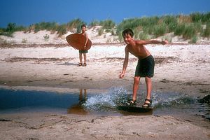
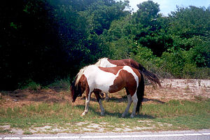
 Andrew Skim BoardingI had read that the wild ponies were even more accessible in this northern section. They weren't kidding. There were ponies all along the side of the road--they practically came up to your window. Unfortunately though, this section of the park didn't have the great biking trails that the southern section had. Instead we just drove the motorhome and stopped at the beach for awhile. The beaches here were absolutely beautiful--much more to my likely than the razzle dazzle of Virginia Beach.
While we were here, we checked out the camping opportunities for future reference. Both the Assateague State Park and the National Park operate campgrounds on the island that are right on the beach. The State Park has a large campground on the ocean side of and the National Park Services operates both an ocean-side and a bay-side campground. The National Park campgrounds were a bit more primitive than the State Park one. Also, we were told that the mosquitoes and biting flies can be pretty bad here in the summer, especially on the bay side. Too bad, because otherwise, the location was fabulous.
Description
Assateague Island is a narrow barrier island that stretches 37 miles along the coastlines of northern Virginia and southern Maryland. You cannot drive from one end of the island to another, but must visit the two sections separately.
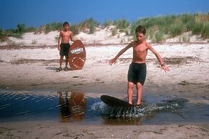
 Tommy Skim BoardingThe island is best known for its wild ponies, made famous by the children's book Misty of Chincoteague. The ponies have lived on Assateague since the 17th century when, according to local legend, their ancestors swam ashore from a shipwrecked Spanish galleon. However, it is more likely that they were placed on the island for free grazing during colonial times. The ponies are quite easy to see, especially on the Maryland side of the island where they have virtually free reign. A lovely place to view them is along the beach in the evening after the crowds have left. The ponies are less accessible on the Virginia side, but you can generally spot some of them along the road or from the observation platforms.
Assateague Island's location along the Atlantic Flyway also makes it a popular place for bird-watchers. More than 200 different species--including peregrine falcons, bald eagles, great blue heron, snowy egrets, and snow geese--have been spotted here.
Besides the wonderful wildlife viewing opportunities, Assateague contains 37 miles of beautiful pristine beaches. Other popular activities include crabbing, clamming, fishing, and kayaking.
Camping facilities are only located on the northern part of the island.
Southern end of Assateague Island
 Wild PoniesThe Virginia side of Assateague Island contains the Chincoteague National Wildlife Refuge and part of Assateague Island National Seashore. The refuge is reached by taking VA Route 175 west across the island of Chincoteague and over a short bridge to the island of Assateague.
The famous annual wild pony swim takes place on Chincoteague Island on the last Wednesday and Thursday in July. Chincoteague "cowboys" round up the entire Virginia herd on Assateague Island (they are separated from the Maryland herd by a fence) and have them swim the channel from Assateague to Chincoteague, where the foals are auctioned off. This event is very popular, so reservations should be made well in advance.
The refuge has several trails for biking. The 3.2-mile Wildlife Loop begins at the Visitor Center and goes through marshes and around a fresh water pond. The Loop is closed to cars until 3 p.m., giving hikers and bikers a chance to spot wild ponies and birdlife up close. The 1.5-mile Woodland Trail goes through a beautiful pine forest and leads to an overlook where you can sometimes see wild ponies. Swans Cove Trail which branches off of Wildlife Loop Trail is about 1.25 miles long and takes you to the beach. The 1-mile Black Duck Marsh Trail also branches off of Wildlife Trail.
The beach itself is in the Assateague Island National Seashore at Tom's Cove on the southern hook of the island. In addition to sunbathing and swimming, shell collecting is very popular and productive on the tip of the spit.
There are no camping facilities on the southern end of Assateague, but there are several commercial campgrounds located on nearby Chincoteague Island.
Northern end of Assateague Island
The Maryland side of the island, which contains both Assateague State Park and the Assateague Island National Seashore, is reached via MD Route 611. It primary attraction is its beautiful sandy beaches.
Biking on Assateague is a great way to explore the island. A paved bike path begins at the pedestrian/bike bridge parking lot, goes over the bike bridge and continues along Bayberry Drive and the Oceanside Campground Road. Bicycles are not permitted on the nature trails in the Maryland section of the island.
There are camping facilities at both the state and national parks. The state park contains 311 sites all located on the oceanside of the island. Reservations for less than a week are not accepted. The National Park Service operates a bay-side and an ocean-side campground that are a bit more primitive than the state park campground. Advance reservations (and they are needed in the summer) are accepted. Mosquitoes and biting flies, which are a real issue during the summer, are much worse on the bay-side.
- ‹ previous
- 2 of 3
- next ›
Assateague Island National Seashore location map
Javascript is required to view this map.
