- Home
- About
- Map
- Trips
- Bringing Boat West
- Migration West
- Solo Motorcycle Ride
- Final Family XC Trip
- Colorado Rockies
- Graduates' XC Trip
- Yosemite & Nevada
- Colorado & Utah
- Best of Utah
- Southern Loop
- Pacific Northwest
- Northern Loop
- Los Angeles to NYC
- East Coast Trips
- Martha's Vineyard
- 1 Week in Quebec
- Southeast Coast
- NH Backpacking
- Martha's Vineyard
- Canadian Maritimes
- Ocracoke Island
- Edisto Island
- First Landing '02
- Hunting Island '02
- Stowe in Winter
- Hunting Island '01
- Lake Placid
- Chesapeake
- Provincetown
- Hunting Island '00
- Acadia in Winter
- Boston Suburbs
- Niagara Falls
- First Landing '99
- Cape Hatteras
- West Coast Trips
- Burning Man
- Utah Off-Roading
- Maui
- Mojave 4WD Course
- Colorado River Rafting
- Bishop & Death Valley
- Kauai
- Yosemite Fall
- Utah Off-Road
- Lost Coast
- Yosemite Valley
- Arizona and New Mexico
- Pescadero & Capitola
- Bishop & Death Valley
- San Diego, Anza Borrego, Joshua Tree
- Carmel
- Death Valley in Fall
- Yosemite in the Fall
- Pacific Northwest
- Utah Off-Roading
- Southern CA Deserts
- Yosemite & Covid
- Lake Powell Covid
- Eastern Sierra & Covid
- Bishop & Death Valley
- Central & SE Oregon
- Mojave Road
- Eastern Sierra
- Trinity Alps
- Tuolumne Meadows
- Lake Powell Boating
- Eastern Sierra
- Yosemite Winter
- Hawaii
- 4WD Eastern Sierra
- 4WD Death Valley +
- Southern CA Deserts
- Christmas in Tahoe
- Yosemite & Pinnacles
- Totality
- Yosemite & Sierra
- Yosemite Christmas
- Yosemite, San Diego
- Yosemite & North CA
- Seattle to Sierra
- Southwest Deserts
- Yosemite & Sierra
- Pacific Northwest
- Yosemite & South CA
- Pacific Northwest
- Northern California
- Southern Alaska
- Vancouver Island
- International Trips
- Index
- Tips
- Books
- Photos/Videos
- Search
- Contact
Bend, OR
Saturday, September 7, 2019 - 5:00pm by Lolo
488 miles and 8.5 hours from our last stop - 1 night stay
Travelogue
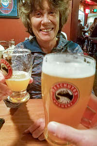
 Lolo enjoying the Deschutes BreweryBend seemed like the perfect jumping off point for our excursion through central and southeastern Oregon, and what better place to start than dinner, and a beer of course, at the Deschutes Brewery Pub - always a favorite. As usual, the food was great and the beers were citrusy and refreshing.
Our plan the next day was to drive along the Oregon Cascades Scenic Byway, stopping to hike, take pictures, and camp along the way. I even managed to get 2 of the 30 daily permits issued each day for the Obsidian Limited Access Area of the Three Sisters Wilderness, so that we could hike to the top of the Middle Sister. They are sold for $6 on Recreation.gov. Permits were sold out for today- I guess because it was the weekend - so I got them for tomorrow (Monday). That gave us all day today to explore various stops along the Byway.
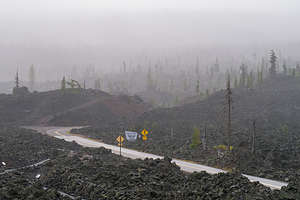
 Rainy day along the Oregon Cascades Scenic BywayOur plan was to go as far as Terwilliger (Cougar) Hot Springs for a soak before turning back and camping at Scott Lake, near the trailhead for our Obsidian hike tomorrow. The Hot Springs sounded awesome -- “set in a picturesque canyon in the Willamette National Forest where from a fern-shrouded hole, 108 degree water spills into a pool then cascades into three successive pools, each one cooler than the one above.” That description definitely got our attention.
Following our Lonely Planet “The Pacific Northwest’s 32 Amazing Road Trips” guide, we headed north from Bend for 22 miles on Highway 20 to Sisters before turning onto Highway 242, which led us through the lovely pine forests of the Three Sisters Wilderness Area.
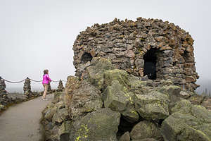
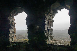
 Lava, lava, lava at the Dee Wright ObservatoryAs we started to climb, the weather shifted drastically, from warm sunny skies to a fine, chilling mist. Our first stop was the Dee Wright Observatory, a structure built entirely of lava rock, perched on a giant mound of lava rock, in the middle of a field of lava rock. The windows of the observatory are situated in such a way to highlight all the prominent peaks that can be seen from the summit. Well not today. The clouds were so thick, that the view from each window was the same - a mass of gray. As if that wasn’t disappointed enough, the temperature had dropped about 20 degrees and we were now being pelted with a steady rain.
In denial, we continued along the Scenic Byway, making our next stop at the Scott Lake Campground, near the Obsidian hike trailhead, where we thought we would camp for the night, so we could get an early start in the morning. It was pretty full, but hopefully people would be leaving, as it was a Sunday.
 What should have been a great view through the windows of the Dee Wright Observatory,As we continued along the drive, and the rain didn’t seem to have any intention of letting up, we started questioning just how badly we wanted to do this hike in the morning. A quick check on the forecast showed that tomorrow would be even worse, with the possibility of thunderstorms in the afternoon, something I did not want to experience on the summit of Middle Sister.
We decided to cut our losses short. The nice part about not overplanning a trip is that you can be flexible and make adjustments based on conditions along the way. Well, this was time for one of those itinerary tweakings. The forecast further east at John Day Fossil Beds National Monument was much better, so we turned around and headed that way, but not without stopping for lunch first in the very cute town of Sisters.
I was a bit disappointed about giving up our Obsidian Trail hike up Middle Sister and our soak in Terwilliger Hot Spring, but it would give us a good excuse (as if we needed one) to come back to Bend in the future.
Description
Bend is the largest city in Oregon east of the Cascades. It is located in the high desert, along the banks of the Deschutes River on the eastern edge of the Cascade Range. A major reason for Bend’s popularity, both as a place to live and as a tourist destination, is its sunny skies. With an annual average of 158 clear days, 105 mostly sunny, and the remaining still with some sunshine, it is the sunniest city in the state.
Bend is also an outdoor enthusiast’s mecca and there is so much to do in all four seasons: skiing the powdered slopes of Mt. Bachelor, kayaking or rafting the mighty Deschutes River, hiking the Three Sisters, golfing at one of its many fine courses, fly fishing the lakes and streams, mountain biking the miles of backcountry trails, and on and on.
For the less active, or for those after an exhausting day of outdoor activity, there is the lively downtown area with its many fine restaurants and shops.
About 25 miles north of Bend is Smith Rock State Park, whose jagged peaks of basalt attract rock climbers from around the world. Considered to be the birthplace of American sport climbing, it has over 1,000 bolted climbing routes. Its stunning location in the Crooked River Gorge also makes it an ideal place for hiking or mountain biking along its many miles of trails
- 1 of 9
- next ›
Bend location map in "high definition"
Javascript is required to view this map.
