- Home
- About
- Map
- Trips
- Bringing Boat West
- Migration West
- Solo Motorcycle Ride
- Final Family XC Trip
- Colorado Rockies
- Graduates' XC Trip
- Yosemite & Nevada
- Colorado & Utah
- Best of Utah
- Southern Loop
- Pacific Northwest
- Northern Loop
- Los Angeles to NYC
- East Coast Trips
- 1 Week in Quebec
- Southeast Coast
- NH Backpacking
- Martha's Vineyard
- Canadian Maritimes
- Ocracoke Island
- Edisto Island
- First Landing '02
- Hunting Island '02
- Stowe in Winter
- Hunting Island '01
- Lake Placid
- Chesapeake
- Provincetown
- Hunting Island '00
- Acadia in Winter
- Boston Suburbs
- Niagara Falls
- First Landing '99
- Cape Hatteras
- West Coast Trips
- Utah Off-Roading
- Maui
- Mojave 4WD Course
- Colorado River Rafting
- Bishop & Death Valley
- Kauai
- Yosemite Fall
- Utah Off-Road
- Lost Coast
- Yosemite Valley
- Arizona and New Mexico
- Pescadero & Capitola
- Bishop & Death Valley
- San Diego, Anza Borrego, Joshua Tree
- Carmel
- Death Valley in Fall
- Yosemite in the Fall
- Pacific Northwest
- Utah Off-Roading
- Southern CA Deserts
- Yosemite & Covid
- Lake Powell Covid
- Eastern Sierra & Covid
- Bishop & Death Valley
- Central & SE Oregon
- Mojave Road
- Eastern Sierra
- Trinity Alps
- Tuolumne Meadows
- Lake Powell Boating
- Eastern Sierra
- Yosemite Winter
- Hawaii
- 4WD Eastern Sierra
- 4WD Death Valley +
- Southern CA Deserts
- Christmas in Tahoe
- Yosemite & Pinnacles
- Totality
- Yosemite & Sierra
- Yosemite Christmas
- Yosemite, San Diego
- Yosemite & North CA
- Seattle to Sierra
- Southwest Deserts
- Yosemite & Sierra
- Pacific Northwest
- Yosemite & South CA
- Pacific Northwest
- Northern California
- Southern Alaska
- Vancouver Island
- International Trips
- Index
- Tips
- Books
- Photos/Videos
- Search
- Contact
Hilo (Big Island), HI
Sunday, January 14, 2018 - 4:30pm by Lolo
0 miles and 0 hours from our last stop - 3 night stay
Travelogue
Day 1 - Mauna Kea, Hawaii Tropical Botanical Garden, Akaka Falls, and arrival at the Grand Naniloa Hotel in Hilo
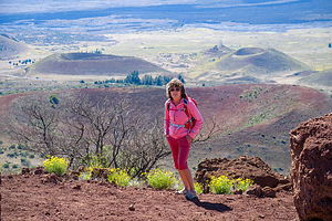 Lolo atop Sunset Hill on Mauna KeaThere are many ways to get to Hilo from Kailua-Kona - the northern route, the southern route, or directly across the middle on Saddle Road. We chose the middle route, as it was the fastest and would take us past two of the island’s largest volcanoes, Mauna Loa and Mauna Kea. The area the road passes through is called The Saddle, because that is the shape of the valley between the two volcanoes.
Although we couldn’t make the entire 14.7-mile drive to the summit of Mauna Kea in our 2WD rental car, we decided to go at least as far as the Visitor Center, 6 miles up the access road. Beyond that, the road gets too rough for anything but 4WD vehicles.
There wasn’t a whole lot to do at the Visitor Center, which wasn’t even open yet, so we took a short hike up to the top of Sunset Hill for a nice vantage point of the area.
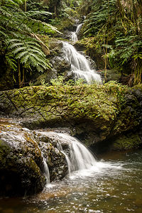 Waterfall in Hawaii Tropical Botanical GardenFrom there, we continued along the Saddle Road to Hilo. Since it was too early to check into our hotel, we decided to pass right through Hilo for now, and visit the highly-acclaimed Hawaii Tropical Botanical Garden, located about 8 miles north of Hilo along the Hamakua Coast’s 4-Mile Scenic Drive.
We paid our $20 admission (per person) - a bit pricey, but well worth it -- and set off across the street to begin our self-guided tour of the gardens, which are set in a lovely, lush 40-acre valley above Onomea Bay.
After crossing under the entrance gate, we followed a 500-foot elevated boardwalk down a steep ravine into a lush tropical rainforest, where we meandered along a series of nature trails, with over 2,500 species of exotic plants, a lovely waterfall, and vistas of Onomea Bay.
What a contrast this lush landscape was from the Kona side of the island, most of which were stark fields of dark lava.
As we learned in the Visitor Center, these beautifully manicured trails and gardens were not the way the valley always was, but rather the untiring efforts of one man from San Francisco, Dan Lutkenhouse, who discovered Onomea Valley in 1977 while on vacation with this wife. Falling in love with the seclusion and beauty of the valley, he purchased a 17-acre parcel without really being able to see it, as the vegetation was so overgrown and impenetrable.
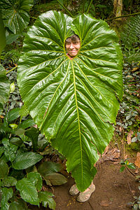 Lolo's creative anti-ballistic missile shieldHe sold his trucking business in San Francisco, moved to the island, and spent the next few decades clearing the jungle and transforming it into a tropical paradise. It truly was a labor of love. Mr. Lutkenhouse, himself, chose the location of every plant and tree introduced to the Garden. Today, the entire valley is treated as a nature preserve.
Some of my favorites included the orchids, birds of paradise, and heliconia. Oh, and there was this one giant leave as tall as me, with an opening on top exactly at my face level - as if it had been made just for me to peek through, like one of those silly plywood figures with cut-out faces at a carnival. Herb and I joked that it was a ballistic missile shield, which would have come in handy during the alert a few days back.
After what had turned out to be a lovely garden tour, we decided to make one more stop before returning to Hilo to check into our hotel. As we often do when we are in a new area, we consulted the Trip Advisor app on our phones to look at the top Things to Do near Hilo, and found Akaka Falls State Park, about 20 minutes further north.
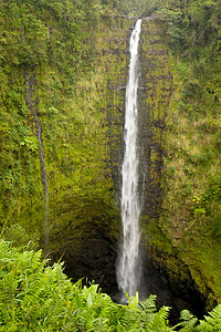 Akaka FallsI hate to appear jaded, but being frequent visitors to Yosemite, where we get close enough to its spectacular waterfalls to actually feel their spray, we are a bit hard to impress.
But this is where we were now, so we paid our $1 and joined the crowd on the 0.5-mile paved path to the viewpoint, where we peeked between the overgrown vegetation at the falls, which were quite far away. I’m sure the 420-foot waterfall would have been much more impressive if we had been able to get a bit closer.
It was after 3:00, so we headed back to Hilo to check into our room at Grand Naniloa Hotel Hilo, where we were pleasantly surprised to find that our 5th-floor room had a balcony with a wonderful view of Hilo Bay and the beautiful outdoor swimming pool. Although there was no full kitchen like we had in Kailua Kona, there was a refrigerator, microwave, and coffee maker.
That evening we took a stroll from the hotel along Banyan Drive to nearby Lili’uokalani Gardens, a 24-acre Japanese garden with banyan trees, fish ponds, bridges, pagodas, statues, and a teahouse. It was absolutely lovely.
From the gardens, we walked over a footbridge to Coconut Island, or Moku ola (“island of life”), once the site of an ancient temple dedicated to healing - something Herb and his stomach virus could use about now. We climbed up a small stone tower on the east side of the island where we had great views of Hilo Bay and our hotel.
Hilo had such a different feel to it than Kailua-Kona, much more tranquil and slow-paced. I kind of liked it.
Day 2 - Hawaii Volcanoes National Park
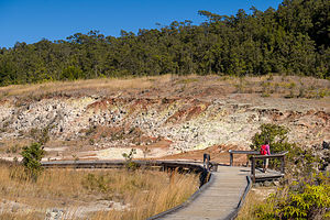 Sulphur Banks in Hawaii Volcano National ParkMoku ola certainly hadn’t done its job of healing. Herb was still feeling quite drained from his stomach virus, and now I had a really bad sore throat. However, although somewhat wounded, we decided to proceed with our plan for the day of visiting Volcanoes National Park.
Visiting Volcanoes was the main reason we chose to come to the Big Island in the first place. Who wouldn’t want to see red molten lava plunge into the sea and watch new land form before your eyes? Unfortunately, as luck would have it (especially our luck this trip), the lava was not flowing. Still there was plenty to see and do in the Park.
We started our trip at the Visitor Center where we watched a very informative 25-minute film called “Born of Fire, Born of the Sea.”
The Park encompasses two active volcanoes: Kīlauea, one of the world's most active volcanoes, and Mauna Loa, the world's most massive shield volcano. Most of the area we would be exploring today would be in and around the Kilauea Caldera.
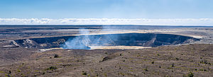 Steam rising from Halema’uma’u CraterFrom the Visitor Center we took a stroll on the Sulphur Banks trail, where we were greeted by the smell of rotten eggs as volcanic gases (hydrogen sulphide, sulfur dioxide, and carbon dioxide) seeped out of the ground along with groundwater steam. Besides being stinky, the area is also quite colorful, because the hydrogen sulphide and steam form deposits of sulphur, gypsum, and hematite on the ground.
From there we passed by the Steam Vents, where puffs of steam rose from the ground as the groundwater seeped down to the hot volcanic rocks below and returned to the surface as steam.
A little bit further on we came to Steaming Bluff, at the edge of the massive Kilauea Caldera, where we got our first view of the steam emanating from the Halema’uma’u Crater. From there, we returned to the Volcano House, across from the Visitor Center, via the Ilahi Trail.
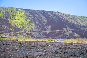 Chain of Craters RoadI love National Park Inns, so I took a quick look inside the Volcano House. When I saw the dining room, with its huge windows looking out over Halema’uma’u Crater, I knew I had to eat there. Herb was still not feeling well enough to enjoy fine dining, so I made a reservation for the following night in the hope that he would rally.
For now, we would continue our tour of the park from the comfort of our car. The main way to see the Park is to drive along the Crater Rim Trail, stopping at various sites along the way. However, in March of 2008, the section of the trail between the Jaggar Museum and the Chain of Craters Road junction was closed indefinitely due to the current eruption in Halema’uma’u Crater, a crater located inside the much larger Kilauea Caldera.
From the Visitor Center, we headed counter-clockwise on Crater Rim Trail to the Jaggar Museum and the Hawaiian Volcano Observatory. Besides the interesting exhibits regarding volcanic activity in the park, this is the best place to see the Halema’uma’u Crater.
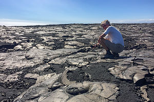 Herb playing with the lava at the end of Chain of Craters RoadThe crater is still active and contains a molten lava lake. During the day, you can see large plumes of steam rising from its vent. However, the real show happens at night, when it gives off an eerie orange glow.
Herb was not feeling great, so we decided to put off the hike down into the Kilauea Iki Crater until tomorrow. Instead we drove the steep, twisty Chain of Craters Road 19 miles down to the sea where it ends abruptly where the current lava flow cut it off. From here there was nothing but miles and miles of desolate, barren, black lava rock as far as the eye can see.
This is near the area where the lava usually flows when heading to the ocean.
We headed back to Hilo, with the plan of returning to the Park the next day to do the Kilauea Iki Crater hike and dinner at the Volcano House
Day 3 - More Hawaii Volcanoes National Park
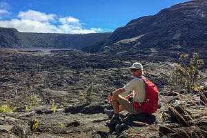 Herb getting ready to descend into Kilauea Iki CraterWe had some unfinished business to do, so back to the Park we went to do the Kilauea Iki Crater hike, highly acclaimed by our “Hawaii Revealed” book as the “if you only have time to do one hike on the Big Island, this is the one.”
The hike started at the Kilauea Iki Overlook and led down through a fern forest to the crater floor, 400 feet below, with several viewpoints into the crater along the way. The descent into the crater is somewhat steep, but there are steps carved into the trail in spots and a few railings to hold onto to ease the way.
When we got to the bottom, we were amazed at the transformation from lush, cool forest to barren lava - so much variety in such a short distance. The crater floor is sort of an open field to wander across, but there were cairns to mark a suggested path.
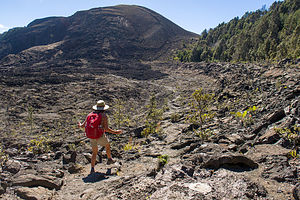 Lolo of Kilauea Iki CraterAbout a third of the way across the crater floor, we stopped for lunch by a large pile of lava rock with steam emanating from the top. Against my wishes, Herb climbed to the top of the pile to check out the steam vent, while I wandered around the rocks on the crater floor trying to make sure he didn’t fall in. He thinks I worry too much. He didn’t and he made me climb up and over the pile as well.
We came out of the crater near the Thurston lava tube where we managed to sneak in between tour buses - it’s a very popular spot. Before entering, we read the board describing how it was formed. From what I recall, it goes something like this: Several hundred years ago during an eruption, low-viscosity lava flowed through this area. The upper layer of the flow cooled first, forming a hard crust, while the molten lava beneath continued to flow in tubular conduits beneath the surface. Because of the insulation of the upper crust, the liquid magma stayed heated enough to travel quite a distance before solidifying as well. Or, something like that.
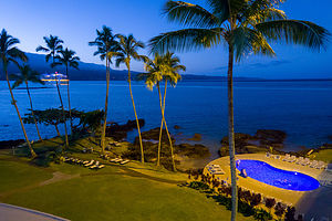 View from our hotel balconyThe section we were able to walk through was about 600 feet long and very well lit. It was definitely pretty cool. One woman was so enthusiastic that after exiting, she went around to the entrance for another turn.
It was only 2:00 and we pretty much had seen what we had wanted to see - plus Herb was dragging a bit - so we canceled our 6:30 dinner reservation at the Volcano House and drove back to Hilo.
We don’t often stay in fancy resorts, as we are usually in our Lazy Daze, so we decided to spend the evening enjoying the beautiful grounds - sipping wine, listening to live music, etc. A lovely way to spend our final evening in Hilo.
Description
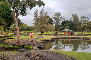 Lili’uokalani GardensUnlike the sunny west side of the island, Hilo, on the eastern side of the island, is the wettest city in the U.S. receiving around 140 inches a year. Whereas the west side is dominated by lava, Hilo is home to numerous waterfalls and lush plant life.
Beyond that, I am not even going to begin to attempt a description of the eastern coast of the Big Island, as there are people that have already done that much better. Instead, I highly recommend purchasing the book "Hawaii The Big Island Revealed" before planning your trip. It has an incredibly detailed wealth of information about everything you need to know.
- ‹ previous
- 2 of 3
- next ›
Hilo (Big Island) location map in "high definition"
Javascript is required to view this map.
