- Home
- About
- Map
- Trips
- Bringing Boat West
- Migration West
- Solo Motorcycle Ride
- Final Family XC Trip
- Colorado Rockies
- Graduates' XC Trip
- Yosemite & Nevada
- Colorado & Utah
- Best of Utah
- Southern Loop
- Pacific Northwest
- Northern Loop
- Los Angeles to NYC
- East Coast Trips
- Martha's Vineyard
- 1 Week in Quebec
- Southeast Coast
- NH Backpacking
- Martha's Vineyard
- Canadian Maritimes
- Ocracoke Island
- Edisto Island
- First Landing '02
- Hunting Island '02
- Stowe in Winter
- Hunting Island '01
- Lake Placid
- Chesapeake
- Provincetown
- Hunting Island '00
- Acadia in Winter
- Boston Suburbs
- Niagara Falls
- First Landing '99
- Cape Hatteras
- West Coast Trips
- Burning Man
- Utah Off-Roading
- Maui
- Mojave 4WD Course
- Colorado River Rafting
- Bishop & Death Valley
- Kauai
- Yosemite Fall
- Utah Off-Road
- Lost Coast
- Yosemite Valley
- Arizona and New Mexico
- Pescadero & Capitola
- Bishop & Death Valley
- San Diego, Anza Borrego, Joshua Tree
- Carmel
- Death Valley in Fall
- Yosemite in the Fall
- Pacific Northwest
- Utah Off-Roading
- Southern CA Deserts
- Yosemite & Covid
- Lake Powell Covid
- Eastern Sierra & Covid
- Bishop & Death Valley
- Central & SE Oregon
- Mojave Road
- Eastern Sierra
- Trinity Alps
- Tuolumne Meadows
- Lake Powell Boating
- Eastern Sierra
- Yosemite Winter
- Hawaii
- 4WD Eastern Sierra
- 4WD Death Valley +
- Southern CA Deserts
- Christmas in Tahoe
- Yosemite & Pinnacles
- Totality
- Yosemite & Sierra
- Yosemite Christmas
- Yosemite, San Diego
- Yosemite & North CA
- Seattle to Sierra
- Southwest Deserts
- Yosemite & Sierra
- Pacific Northwest
- Yosemite & South CA
- Pacific Northwest
- Northern California
- Southern Alaska
- Vancouver Island
- International Trips
- Index
- Tips
- Books
- Photos/Videos
- Search
- Contact
Mars Desert Research Station, Factory Butte, and Moonscape Overlook, UT
Saturday, May 31, 2025 - 4:00pm by Lolo
100 miles and 3 hours from our last stop - 1 night stay
Travelogue
Mars Desert Research Station
.thumbnail.jpg) Mars Desert Research StationAfter our lunch at Duke’s Slickrock Grill in Hanksville (population 170), we headed back west on Ut-24 for 3 miles and then made a left onto Cow Dung Road towards the Mars Desert Research Station (MDRS). From there we drove about 4 miles through the incredible red and white bentonite hills before coming to the Mars Desert Research Station.
Mars Desert Research StationAfter our lunch at Duke’s Slickrock Grill in Hanksville (population 170), we headed back west on Ut-24 for 3 miles and then made a left onto Cow Dung Road towards the Mars Desert Research Station (MDRS). From there we drove about 4 miles through the incredible red and white bentonite hills before coming to the Mars Desert Research Station.
This area was chosen for the MDRS because of the Bentonite Hills and badlands striking resemblance to the surface of Mars. So much so that it was used as the setting of the fictional planet Vulcan in the 2009 film Star Trek.
.thumbnail.jpg) Feels like MarsLike Mars, the terrain is barren and rocky with minimal vegetation, featuring red and orange sandstone formations. It is otherworldly.
Feels like MarsLike Mars, the terrain is barren and rocky with minimal vegetation, featuring red and orange sandstone formations. It is otherworldly.
Built and managed by the Mars Society, the Mars Desert Research Station is one of only four simulated Mars habitats in the world being used to simulate the hardships and challenges that pioneers would face in a potential colonization of Mars.
Although not allowed on the grounds, we could see several of the buildings. The two-story, eight-meter cylindrical one is called the “Habitat,” also known as “Hab.”
.thumbnail.jpg) Annual University Rover ChallengeAstronauts and research crews spend two weeks at a time living in Hab. To most realistically simulate the Martian environment, they wear space suits and carry walkie talkies whenever they step outside Hab.
Annual University Rover ChallengeAstronauts and research crews spend two weeks at a time living in Hab. To most realistically simulate the Martian environment, they wear space suits and carry walkie talkies whenever they step outside Hab.
It would have been so cool to see astronauts wandering around the bentonite hills, but I later learned that they are only here from October to May. We must have just missed them.
Last time we visited, there was absolutely no one here, so we were quite confused as to why there were dozens of cars and hundreds of people. Well it turned out that we had stumbled upon the annual University Rover Challenge, the world's premier robotics competition for college students where teams design and build the next generation of Mars rovers that will one day work alongside astronauts exploring the Red Planet.
Factory Butte
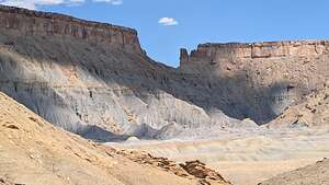 North Caineville MesaAfter the Mars Desert Research Station, our next plan was to drive by Factory Butte and then on towards the Moonscape Overlook to camp for the night.
Rather than take the shortest way to the east side of Factory Butte, we decided to drive around the entire Butte. So rather than turn right onto Factory Butte (Coal Mine) Road, we continued on to the town of Caineville and turned right onto the road that we came out of at the end of our Cathedral Valley Loop drive earlier today.
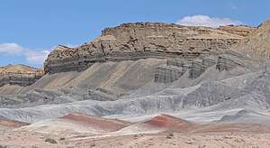 North Caineville MesaWhen we came to a junction, rather than turn left to do the Cathedral Valley Loop again in reverse, we took a right to follow the North Caineville Reef to Factory Butte.
Factory Butte is a massive, 6,302-foot monolith that rises dramatically from the surrounding "lunar badlands."
Driving around it is interesting, because it actually looks quite different from different perspectives.
.thumbnail.jpg) One perspective of Factory ButteMormon settlers got here first, so they got the chance to name it. They thought it looked a bit like a large woolen mill (factory) back in Provo, so “Factory” Butte it became. They must have been homesick.
One perspective of Factory ButteMormon settlers got here first, so they got the chance to name it. They thought it looked a bit like a large woolen mill (factory) back in Provo, so “Factory” Butte it became. They must have been homesick.
Most others don’t think of a woolen mill when looking at this very impressive formation, but rather it is more often described as a cathedral or sand castle.
The ripples at the base of Factory Butte are what make it so photogenic.
These “ripples” are essentially layers of ancient mud and clay that have been exposed and sculpted by erosion over millions of years.
.thumbnail.jpg) Factory Butte and it's ripplesMillions of years ago, this area of Utah was covered by a vast, shallow inland sea, the bottom of which was covered with layers of mud and clay particles. Eventually these layers were compressed and cemented together to form a soft rock called Mancos Shale.
Factory Butte and it's ripplesMillions of years ago, this area of Utah was covered by a vast, shallow inland sea, the bottom of which was covered with layers of mud and clay particles. Eventually these layers were compressed and cemented together to form a soft rock called Mancos Shale.
This shale isn't a single color because it contains different minerals that give it varying shades.
.thumbnail.jpg) Sunrise on Factory ButteThe Mancos Shale is relatively soft, so it erodes more easily than the harder rock that forms the top of Factory Butte.
Sunrise on Factory ButteThe Mancos Shale is relatively soft, so it erodes more easily than the harder rock that forms the top of Factory Butte.
As the shale eroded, the different colors (greys, purples, oranges, and golds) within them became exposed.
Since erosion happens unevenly, it creates what looks like wavy, colorful ripples across the base of the butte.
I can’t say it enough, but nature is an incredible artist.
Moonscape Overlook
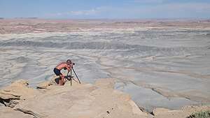 Moonscape OverlookWhen we had gotten about three-quarters of the way around Factory Butte, we started looking on Gaia for the turnoff towards the Moonscape Overlook (also called Skyline Rim Overlook).
There are no signs on these roads indicating where anything is, so we had to rely on Google Maps and Gaia to get where we wanted to go.
We had been here two years ago, so we could follow our tracks on Gaia. Once making the turn, we drove for about 2 miles across a flat expanse, at the end of which we found ourselves perched on the edge of a cliff, looking out over an expanse of badlands, known as the Blue Valley, below us and the Henry Mountains in the distance. It was mind blowing.
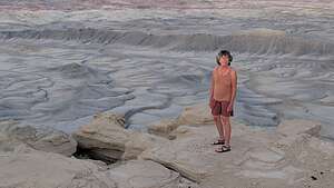 Moonscape OverlookThere was only one other camper van at the overlook, parked a bit away from the edge, so we went a little closer and parked for the night at what Herb thought was the best spot to set up a tripod and watch the light change.
It is one of the most stunning landscapes we have ever camped at, with Moonscape just out my window on one side and Factory Butte on the other.
.thumbnail.jpg) Sunset at MoonscapeWe set out our chairs to settle in for the evening here, and Herb set his tripod up on one of the outcrops over the badlands. Then we sat and watched the light change and took some photos of this breathtaking scenery.
Sunset at MoonscapeWe set out our chairs to settle in for the evening here, and Herb set his tripod up on one of the outcrops over the badlands. Then we sat and watched the light change and took some photos of this breathtaking scenery.
The light was good, but we knew it was going to be even better in the morning.
.thumbnail.jpg) Crazy person waiting for sunriseWe crawled into the back of the 4Runner to get some sleep.
Crazy person waiting for sunriseWe crawled into the back of the 4Runner to get some sleep.
The next morning, before we even got up, we saw several headlights headed our way. By the time we got out of the 4Runner, over 20 cars were pouring into our little secluded paradise.
Herb quickly went out and set up his tripod, claiming the vantage point he wanted for sunrise. We felt we had earned it. Afterall, we slept here all night while all these people were probably in a hotel room.
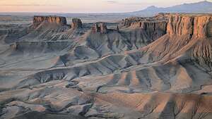 Sunrise hits MoonscapeThe sun lit up Factory Butte behind us first.
Then we waited for the sun to light up the badlands below us in all their splendor. It was magical.
There were photographers scattered on every outcrop. Some idiots were even climbing up on a precarious narrow spire to take selfies of themselves. You couldn’t pay me enough to risk that for a photo. What a difference from last night when we had the whole place to ourselves.
.thumbnail.jpg) The waves of Moonscape OverlookI walked over to the other side of the overlook, where the sun was beginning to light up what looked to me like a series of sandstone waves
The waves of Moonscape OverlookI walked over to the other side of the overlook, where the sun was beginning to light up what looked to me like a series of sandstone waves
Once the sun was up, people started getting back in their cars and driving back towards Factory Butte. Just as quickly as they came, they were gone, and we once again had this lovely place to ourselves.
After a quick breakfast, we got back in the 4Runner and headed back to planet Earth, also known as Highway 24.
From here we would start heading home, with one more stop in Utah red rock country along the way - Snow Canyon State Park.
- ‹ previous
- 6 of 7
- next ›
Mars Desert Research Station, Factory Butte, and Moonscape Overlook location map in "high definition"
Javascript is required to view this map.
