- Home
- About
- Map
- Trips
- Bringing Boat West
- Migration West
- Solo Motorcycle Ride
- Final Family XC Trip
- Colorado Rockies
- Graduates' XC Trip
- Yosemite & Nevada
- Colorado & Utah
- Best of Utah
- Southern Loop
- Pacific Northwest
- Northern Loop
- Los Angeles to NYC
- East Coast Trips
- Martha's Vineyard
- 1 Week in Quebec
- Southeast Coast
- NH Backpacking
- Martha's Vineyard
- Canadian Maritimes
- Ocracoke Island
- Edisto Island
- First Landing '02
- Hunting Island '02
- Stowe in Winter
- Hunting Island '01
- Lake Placid
- Chesapeake
- Provincetown
- Hunting Island '00
- Acadia in Winter
- Boston Suburbs
- Niagara Falls
- First Landing '99
- Cape Hatteras
- West Coast Trips
- Utah Off-Roading
- Maui
- Mojave 4WD Course
- Colorado River Rafting
- Bishop & Death Valley
- Kauai
- Yosemite Fall
- Utah Off-Road
- Lost Coast
- Yosemite Valley
- Arizona and New Mexico
- Pescadero & Capitola
- Bishop & Death Valley
- San Diego, Anza Borrego, Joshua Tree
- Carmel
- Death Valley in Fall
- Yosemite in the Fall
- Pacific Northwest
- Utah Off-Roading
- Southern CA Deserts
- Yosemite & Covid
- Lake Powell Covid
- Eastern Sierra & Covid
- Bishop & Death Valley
- Central & SE Oregon
- Mojave Road
- Eastern Sierra
- Trinity Alps
- Tuolumne Meadows
- Lake Powell Boating
- Eastern Sierra
- Yosemite Winter
- Hawaii
- 4WD Eastern Sierra
- 4WD Death Valley +
- Southern CA Deserts
- Christmas in Tahoe
- Yosemite & Pinnacles
- Totality
- Yosemite & Sierra
- Yosemite Christmas
- Yosemite, San Diego
- Yosemite & North CA
- Seattle to Sierra
- Southwest Deserts
- Yosemite & Sierra
- Pacific Northwest
- Yosemite & South CA
- Pacific Northwest
- Northern California
- Southern Alaska
- Vancouver Island
- International Trips
- Index
- Tips
- Books
- Photos/Videos
- Search
- Contact
Mojave Road - Near Marl Springs (mile 77) to entrance to Afton Canyon (mile 116), CA
Friday, October 19, 2018 - 3:00pm by Lolo
39 miles and 4 hours from our last stop - 1 night stay
Travelogue
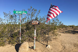 Mojave Post OfficeNext morning, it was coffee and Nature Valley Honey ‘n Oat granola bars again before hitting the road.
We were getting on near 20 miles from Rock Springs, so right on queue at mile 70.7, we arrived at Marl Springs. For early travelers, this was probably the most vital water source on the whole route, because afterwards it was another 30 miles across the barren Devil’s Playground and often uncrossable Soda Lake before reaching Soda Springs. There might not have been a Mojave Road if it wasn’t for this spring.
Like the previous two springs (Piute and Rock), this one also had a military outpost, which actually withstood an Indian attack in 1867. Once the U.S. mail was taken off the Mojave Road and the fort was no longer needed, Marl Springs became the headquarters for one of the earliest cattle operations in the Mojave. When the National Park Service acquired ownership of the land, all the ranches and cattle were removed, and today there is nothing but a corral and an old water trough to mark its once significant role.
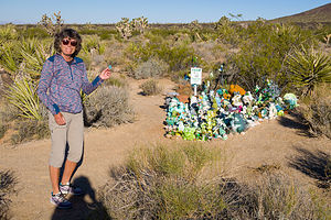 Lolo ready to make our contribution to the Frog GardenIt was a little confusing leaving Marl Springs, so we were careful to follow the cairns, always keeping them on our right. The next stretch of the road had great views of dramatic lava flows and cinder cones, the biggest one being Cima Dome.
But first, we had a true Mojave Road icon to visit - the Mojave Road Mailbox (mile 74.0), put there by the Friends of the Mojave Road in 1983. Inside the box is a book in which passing travelers are asked to sign, including information as to the number of people in their party, the date, and their impressions of their journey. We signed it under our trip personas - Dora the Explorer and Nigel Thornberry. It seemed like a good idea at the time.
Although not mentioned in our guidebooks, Herb had seen on Youtube that there is a frog garden a short distance behind the mailbox. Being the well-prepared travelers we are, we had brought along a tiny little rubber frog to add to the mix. I hoped he would make friends, as he was the smallest one in the crowd.
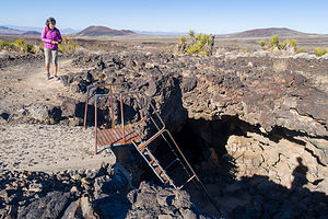 Approaching the lava tubeAt mile 79.0, we left the Mojave Road for a quick diversion 3 miles north on the Aiken Cinder Mine Road to a lava tube. From the parking lot, it was just a short ¼ mile walk to the tube entrance where there was a metal ladder to climb down into the tube.
This was not our first lava tube, so we knew a little bit about how they were formed. First of all, not all lava is the same. The kind that forms lava tubes has got to be the low-viscosity, basaltic type that spreads out smoothly like hot maple syrup. As the lava flows, it began to cool. However, the upper layer of the flow would cool first, forming a hard crust, while the liquid lava below kept moving underneath, creating a tunnel, or as geologists call it, a lava tube.
At mile 85.5, we crossed the Kelbaker Road, connecting Kelso Depot in the south and the town of Baker on I15 to the north. Once again, we continued on.
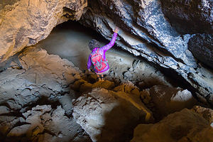 Lolo enters the Lava TubeIn 2 more miles we came to Seventeenmile Point (mile 87.8), the midpoint on the longest stretch of the Mojave Road without water - 17 miles to Soda Springs to the west, and 17 miles to Marl Spring to the east. From here, Soda Lake, the next potential problem, came into view.
Soda Lake is actually a misnomer, as there is no water in Soda Lake. It’s actually a dry lake. However, it does have standing water during wet periods, and there is sometimes water right beneath the surface, both of which can cause vehicles to sink in and get stuck. The ability to safely cross it depends on how long it’s been since the last rain and how big that rain was. Herb had called the Ranger Station before we left home and was told that we would have no problem.
We came to the eastern edge of Soda Lake at mile 96.9. It was pretty easy to see what track we should follow across the lake as there were green metal fence posts driven into the ground to show the way. We could see that some people had tried to drive outside the posts and had dug in and created ruts. They probably had done that for fun. We, however, didn’t need any extra excitement and greatly enjoyed our smooth 5 mile ride across the lake.
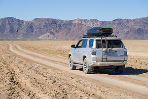 Crossing Soda LakeIn the old days, the route across the lake used to go directly to Soda Springs, frequently called Zzyzx, which has a very interesting history - too long for me to go into here, but I would very much suggest googling it. Since the area around the actual Soda Spring gets too muddy, the Mojave Road now takes a more southerly path across the lake.
Our path guided us right to a large pile of rocks on the western edge of the lake called the Travelers Monument (mile 100.9). Every traveler that passes this way is encouraged to add a stone to the pile. Since Herb had researched this trip so thoroughly, we were prepared with a stone from our garden. It had sat waiting in our cupholder the whole way, along with the penny for the Penny Can and the frog for the Frog Garden.
After leaving the lake, we continued on, soon leaving the Mojave National Preserve and entering the BLM’s Rasor Off-Highway Vehicle Area, where people like to bring their jeeps and race around across the sand and rocks. Since people pretty much drove anywhere they wanted here, it became even more important to look for the cairns that would keep us on the route of the Mojave Road.
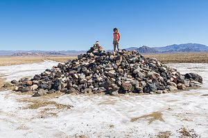 Lolo atop the Travelers MonumentWe continued on across the Mojave River Floodplain coming to the intersection with Rasor Road (mile 104.3), a dirt road that was just 5.1 miles away from I15 in the north. The guidebook warned that beyond this point lie drifting soft blow sand and rough conditions. Quite honestly, I felt that this would be an appropriate place to declare victory and get back to civilization, but Herb was having none of it. He wanted another night of camping in the desert.
In another 10 miles, we reached Basin Road, another road which led to I15. Although Herb was not ready to take it yet, this would be the road we would use tomorrow morning, as we had already decided that we did not want to go through Afton Canyon, which would require us driving through the Mojave River (twice).
We started looking for a nice place to camp for the night. There were a few potentials, but we continued on under the lower railroad bridge at the mouth of the Afton Canyon before turning around and selecting one just about a mile shy of Basin Road.
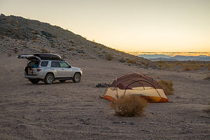 Our final campsite along the Mojave RoadIt was okay, but not nearly as nice as the one last night. It was definitely less remote. The railroad was nearby so we saw and heard freight trains passing, and the Cave Mountain Iron Mine was behind us in the hills. The sandy conditions, however, were conducive to setting up the tent, making sleeping much easier.
Tonight’s gourmet meal consisted of Knorr Rice with 2 packages of Chicken of the Sea pink salmon thrown it. Really not bad and we actually prefer them to the commercial backpacking meals.
The next morning it was coffee and a Nature Valley granola bar and back out to civilization via Basin Road. We had done it - 116 miles on the Mojave Road with the 4Runner and Herb performing like champs.
- ‹ previous
- 4 of 7
- next ›
Mojave Road - Near Marl Springs (mile 77) to entrance to Afton Canyon (mile 116) location map in "high definition"
Javascript is required to view this map.
