- Home
- About
- Map
- Trips
- Bringing Boat West
- Migration West
- Solo Motorcycle Ride
- Final Family XC Trip
- Colorado Rockies
- Graduates' XC Trip
- Yosemite & Nevada
- Colorado & Utah
- Best of Utah
- Southern Loop
- Pacific Northwest
- Northern Loop
- Los Angeles to NYC
- East Coast Trips
- 1 Week in Quebec
- Southeast Coast
- NH Backpacking
- Martha's Vineyard
- Canadian Maritimes
- Ocracoke Island
- Edisto Island
- First Landing '02
- Hunting Island '02
- Stowe in Winter
- Hunting Island '01
- Lake Placid
- Chesapeake
- Provincetown
- Hunting Island '00
- Acadia in Winter
- Boston Suburbs
- Niagara Falls
- First Landing '99
- Cape Hatteras
- West Coast Trips
- Utah Off-Roading
- Maui
- Mojave 4WD Course
- Colorado River Rafting
- Bishop & Death Valley
- Kauai
- Yosemite Fall
- Utah Off-Road
- Lost Coast
- Yosemite Valley
- Arizona and New Mexico
- Pescadero & Capitola
- Bishop & Death Valley
- San Diego, Anza Borrego, Joshua Tree
- Carmel
- Death Valley in Fall
- Yosemite in the Fall
- Pacific Northwest
- Utah Off-Roading
- Southern CA Deserts
- Yosemite & Covid
- Lake Powell Covid
- Eastern Sierra & Covid
- Bishop & Death Valley
- Central & SE Oregon
- Mojave Road
- Eastern Sierra
- Trinity Alps
- Tuolumne Meadows
- Lake Powell Boating
- Eastern Sierra
- Yosemite Winter
- Hawaii
- 4WD Eastern Sierra
- 4WD Death Valley +
- Southern CA Deserts
- Christmas in Tahoe
- Yosemite & Pinnacles
- Totality
- Yosemite & Sierra
- Yosemite Christmas
- Yosemite, San Diego
- Yosemite & North CA
- Seattle to Sierra
- Southwest Deserts
- Yosemite & Sierra
- Pacific Northwest
- Yosemite & South CA
- Pacific Northwest
- Northern California
- Southern Alaska
- Vancouver Island
- International Trips
- Index
- Tips
- Books
- Photos/Videos
- Search
- Contact
Anza-Borrego State Park, CA
Friday, February 10, 2017 - 9:15am by Lolo
80 miles and 1.5 hours from our last stop - 6 night stay
Travelogue
Day 1 – Borrego Palms Canyon Hike
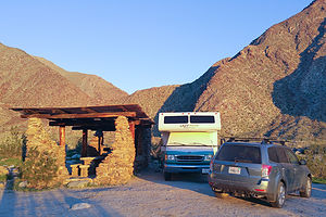 Our lovely campsiteAs I mentioned in the overview, our journey to Anza-Borrego came about as a result of a chance encounter in Yosemite with a fellow Lazy Daze owner, who not only told us how wonderful Anza Borrego was, but offered us their campground reservation at the Borrego Palms Canyon Campground, as they were unable to use it. This might not sound like much, but Anza-Borrego is extremely popular in February, and the campsite they had booked was the most highly-coveted one in the park. They weren’t kidding!
The campground had three sections: one for hookups, one for tent campers, and one for RV dry camping. Normally, I would have gone for the hookup, especially since we were going to be there 6 nights, but thankfully, I didn’t have the choice. While the hookup sites were nice enough, they were your usual asphalt parking lot with motorhomes separated by a few feet.
The dry camping area, however, was unbelievable. Our campsite, which was probably about an acre in size, was set right into the entrance to Borrego Palm Canyon, with incredible views out our back window. Rather than just an ordinary picnic table, we had a “Ramada” built by the Army Corp of Engineers in the 1930s. It was a beautiful stone and wooden structure that housed two large concrete picnic tables and a beautiful stone fireplace. We felt like the lords of the manor.
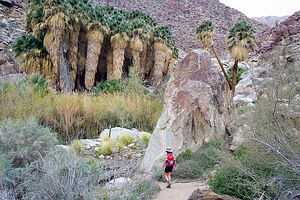 Our own little oasisAnother perk was that the trailhead for the 3.5-mile (RT) Borrego Palms Canyon hike, one of the premier hikes in the park, was in walking distance from our site.
Since it was only 3:30, we decided to set out on the trail that afternoon. In retrospect, I think it would have been better to do the hike in the morning when the morning sun paints the canyon with light. By 3:30, the shadows were already filling in the canyon.
For about a half mile, the trail meandered along a landscaped path bordered by boulders and ocotillo cacti before coming to our first creek crossing. From this point on, the trail became a bit confusing. I am sure that we zig zagged back and forth across that creek too many times in our attempt to follow the trail, but we couldn’t get too lost, as all we had to do was head towards the tops of the palm trees that we could see in the distance.
Eventually, we came to a short stone staircase, and after crossing the stream a few more times, we entered the Borrego Palm Oasis, one of the largest and last remaining naturally occurring native California palm groves on the planet.
 Lolo among the PalmsIt was so lush and green that it was hard to believe we were in a desert – not to mention all the stream crossings we had done and would have to repeat on the way back.
As impressive as the grove is, it has a lot fewer mature palms today as a result of severe flashfloods in 2003 and 2010, which wiped out a significant number of trees, the trunks of which are scattered throughout the canyon. I mistakenly bumped into a dead branch and was surprised to look down and find my leg bleeding. Palm trees always seem so innocuous to me, but even they have sharp thorns for defense.
The grove was making a comeback though. There were lots of cute little palm trees sprouting up throughout.
We retraced out steps back out of the canyon, crisscrossing the stream again and again. It was almost dark by the time we got back to our campsite. The sun disappears behind the canyon walls so early this time of year.
Day 2 – Hellhole Canyon Hike to Maidenhair Falls and 4WD to Fonts Point
 Hellhole Canyon palm oasisWe woke that morning, as we would every morning during our stay here, to an incredible view out our back window of the canyon, colorfully painted by morning light.
Our first stop that day was to the nearby Visitor Center, mostly to find out about 4WD road conditions, as that was something Herb very much wanted to do with our Subaru. We already had two excellent books: “California Desert Byways” and “The Anza-Borrego Desert Region,” which is pretty much the Bible for exploring the park, but it’s always wise to get some local knowledge as to the current road conditions.
While at the Visitor Center, we also picked up their informative “At Home in Anza-Borrego Desert Park Brochure,” which has recommendations for things to see and do in the park. I took it as my personal challenge to do as many of them as we could, which brought fear to Herb’s heart as he visualized any chance of his dream of just sitting still in the sun, reading a book and not moving, eluding him.
Herb watched warily as I checked Borrego Palms Canyon hike off on my Things to See and Do grid and plotted our next day’s adventure. He was not amused when I told him that I was going to try to get Bingo by checking off the entire grid.
First stop for the day – Hellhole Canyon, a 5-mile hike into a narrow canyon to a hidden waterfall oasis. This time we had to drive to the trailhead, which was just a mile south of the Visitor Center on Montezuma Valley Road (S22).
 Maidenhair Falls in Hellhole CanyonThe hike began on the California Riding and Hiking Trail, where we meandered through typical desert scrubland before the Hellhole Canyon Trail split off at about 0.3 miles. We were able to identify cholla and ocotillo cacti, but there were plenty of other interesting desert plants that I wish we knew more about. We probably should have taken the short Nature Trail by the Visitor Center to learn more before setting out on our own.
Soon after the split, we came upon a pile of rocks resembling a grave with a sign reading “they didn’t bring enough water,” an ominous warning to those that do not take the harshness of the desert seriously. I think that danger applies to summer hikes, but I found myself instinctively checking to make sure my water bottles were in the side pockets of my backpack.
Eventually the trail climbed out of the wash and the walls of the canyon began closing in. There really was no set trail, so we spent the next mile and a half or so crisscrossing streams, bushwacking, and rock scrambling. It was quite confusing.
We eventually came to a grouping of about two or three short palm trees, but continued on hoping that this was not the oasis we were promised – and there was definitely no waterfall here. After a bit, we came to the second oasis, lusher and thicker, huddled around a stream.
We still had no idea where the waterfall was, but fortunately we met some returning hikers that told us we were almost there. They were right. After a bit more scrambling we arrived at a third oasis and lovely Maidenhair Falls, trickling over moss-covered canyon walls into a shallow pool.
I would say that we retraced our steps back, but we really had no idea just which of the many footprints in every direction were ours. We figured we would be fine if just followed the stream downwards.
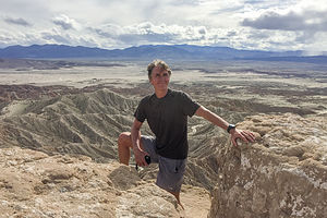 Herb on Fonts PointAll in all, the hike was 5.3 miles with about a 1,000 foot elevation gain.
Herb was itching to get the Subaru off-road, so we consulted his California Desert Byways guide for a recommendation. Since we were relatively new at this, and the Subaru is not as hardcore an off-road vehicle as a Jeep, we wanted to ease into this gently. Plus, we weren’t in it for the love of rock crawling, but rather as a means to get to some beautiful, desolate areas.
Fonts Point seemed like the perfect place to start – 7.8 miles round trip over a relatively easy, but very sandy road, with a big reward at the end – spectacular view of the Borrego Badlands, the Salton Sea, and the Fish Creek Mountains in the distance.
The Subaru performed like a champ and the drive was really fun. We would definitely be doing more of this during our stay in Anza-Borrego.
Day 3 – 4WD Fish Creek Wash, Wind Caves Hike, and Galleta Meadows
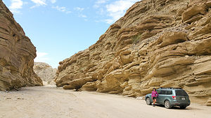 Fish Creek WashThe off-roading to Fonts Point yesterday had been so rewarding and fun that we decided to take on a longer and slightly more challenging one – the 25 mile (RT) drive up Fish Creek Wash to Sandstone Canyon. Plus, the author of our “California Desert Byways” guide said, “If you do only one drive in the park, this should be the one.” Sounded like a plan.
We packed lunch and headed out, this time east on Route 78 to the town of Ocotillo Wells. From there, we went south on Split Mountain Road for about 8 miles to the beginning of the Wash. At the entrance, we reset our odometer, so that we could follow the mile by mile description of the drive in Lindsay’s “Anza-Borrego Desert Region Guide,” considered the Bible by the Visitor Center.
After about a mile and a half of relatively easy driving, we entered Split Mountain Gorge, a narrow cut in the mountains where cliff walls, several hundred feet high, towered above us. The split separates the Vallecito Mountains on the right and the Fish Creek Mountains on the left.
 Herb in Wind CavesAt mile 3.8, we stopped to admire the fascinating anticlines on the canyon walls, where the rock layers had been bent and twisted into U-shaped bows and curves by tectonic activity millions of year ago. They were beautiful.
At mile 4.4, we parked at the trailhead for the Split Mountain Wind Caves. The trail was not exactly obvious. We followed a faint scar up the steep east side of the wash and eventually found the wind caves, a collection of sandstone formations with wind-eroded pockets, some of them large enough to crawl through and sit in. Even without the fascinating wind caves, the views of the Carrizo Badlands below made the 1.3-mile hike worthwhile.
Back in the Subaru, we continued along the Wash, bypassing the choice at mile 7.2 for the Loop Wash spur.
 Sandstone CanyonAt mile 10.7 we came to an interesting sandstone rock formation known as the Layer Cake, because of its multi-colored bands of green and gray.
A little bit further, at mile 12.5, we reached Sandstone Canyon, a high wall, narrow slot canyon that was drivable until 1992, when thousands of tons of debris came tumbling down near its mouth. We parked at the entrance and walked for about a half mile into the canyon.
After a lunch break, we retraced our route back to Split Mountain Road.
As we were driving back to the campground along Borrego Springs Road, Herb noticed a huge metal elephant off to our right. We immediately turned off onto a dirt road and soon found ourselves driving past majestic elephants, rearing stallions doing battle, and frighteningly giant birds. We had found ‘Galleta Meadows! Or, at least a small part of it.
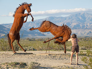 Galletta Meadows - Fighting StallionsIn preparation for this trip, Herb had watched dozens of YouTube videos on things to do and places to see in and around Anza-Borrego and had come across Galleta Meadows, a collection of more than 100 gigantic metal sculptures scattered across the barren landscape around the park.
Although we got out of the car to take pictures, you can actually just drive past the sculptures along the dirt road. We met a woman that told us that this is just a tiny sampling of the sculptures and that many more of them could be seen just north of the town of Borrego Springs.
Since it was already getting close to losing the good light of the day, we decided to save that for first thing tomorrow morning.
Day 4 – More Galleta Meadows, Alcoholic Pass Hike, and Little Surprise Canyon
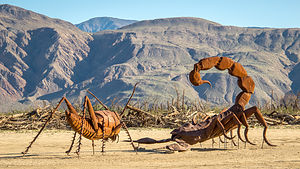 Galleta Meadows - Dueling ScorpionsWe awoke to another beautiful sunrise in Borrego Palm Canyon. Not wanting to miss the low light, we set out to find the main Galleta Meadow in search of the Sea Dragon.
This time, when we got to Christmas Circle in the town of Borrego Springs, we turned north on Borrego Springs Road. It wasn’t long before bizarre metal sculptures began randomly popping out of the desert landscape. They were everywhere.
The first one we came across was a 15-foot scorpion waging battle with an equally large grasshopper. The detail was amazing.
Our personal favorite was the Sea Dragon, a 350-foot long sea serpent whose body submerges and emerges from the ground. It even crossed the road. It has the head of a dragon and the tail of a rattlesnake. You have to see it to believe it.
 Desert SerpentNot all the sculptures were of frightening beasts, however. In fact, one of my non-scary favorites was of a prospector panhandling for gold. When I saw that his pan was filled with coins, I added a quarter of my own for good luck. Nearby him stood his horse, loaded down with a pack that was amazing in its detail.
Another fun one was a jeep crawling up a mound of rocks, very fitting for a park with hundreds of miles of 4WD roads.
You can spend a whole day exploring these unique sculptures – there are 130 of them in all, and I have a feeling next time we visit, there will be more.
They are the work of an artist named Ricardo Breceda, who was commissioned in 2008 by Dennis Avery, the owner of the Galleta Meadows Estate, to create a collection of prehistoric creations on his three square miles of undeveloped land in Borrego Springs. Since then, the collection has grown to include human figures, like the gold miner I mentioned, along with contemporary animals, such as big horn sheep, elephants, tortoises, horses, and more.
This alone makes a visit to Borrego Springs worthwhile.
 View of Coyote Canyon from Alcoholic PassSince we were already up in the northern part of the park, we drove into Coyote Canyon and hiked the steep 2.3-mile (RT) Alcoholic Pass Trail to a lovely view of Coyote Canyon and the surrounding mountains. We wondered about the name, but the only theory we found was that the trail, which is steep and full of switchbacks, wanders this way and that, sort of like a drunk – hence the name, Alcoholic Pass.
We had time for one more short hike, so we took the ranger’s recommendation and drove down to the trailhead for Hellhole Canyon, to do the short 0.6-mile hike into Little Surprise Canyon. It was a nice, short hike, but we were a bit too early in the season, as this hike is best when the wildflowers are blooming.
That evening Herb made a campfire in our lovely Ramada stone fireplace. This campsite really was awesome.
Day 5 – Slot Canyon Hike, Side Trip to the Salton Sea, and 4WD 17 Palms
 Approach to "The Slot"There are a lot of nice hikes in Anza Borrego, but the only one rated a 10 in my Moon California Hiking Guide was The Slot, a short hike down into a narrow siltstone canyon.
To get to the trailhead, we took the Borrego Springs Road southwest to Route 78 East. We drove about a mile and half on 78 to the unmarked, and difficult to find dirt Butte Pass Road. After about a mile, we took a left at the fork and continued for another mile to the parking area for The Slot.
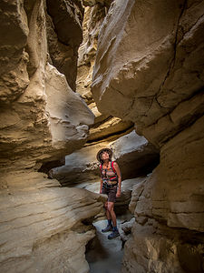 "The Slot"From the parking area, there is not an official trail marker, but there are plenty of footprints leading down into the ravine below. It’s quite steep and slippery.
From the bottom we turned left into a large crevice, which was the entrance to The Slot. As we proceeded through the canyon, the walls became taller and closer together. Soon we found ourselves squeezing through sections where the walls were less than shoulder width apart.
The twisting pink and tan siltstone walls, with the blue skies above, made for some very interesting photos.
At about 0.3 miles we passed underneath a rather precarious looking rock slab lodged between the two walls, forming a bridge above us. Hopefully, today wouldn’t be the day that it became dislodged.
 Out the other end of "The Slot"Soon afterwards, the canyon widened and we found ourselves on a jeep road, which we followed for about another mile before turning back. It was beautiful. There were colorful siltstone cliffs all around us and mountains on the horizon. There were even some wind caves in the distance. This would have been a worthwhile hike even without The Slot.
Rather than continue onto the wind caves, we decided to turn back, because we still had a full day ahead of us, as we planned to drive out to the Salton Sea, just beyond the eastern boundary of the park.
The Salton Sea has a rather interesting history:
 Salton SeaIt was formed in 1905 when the Colorado River breached its dikes and filled the Salton Basin. It took 18 months to get the river back on course, but the water remained. At 35 miles long and 15 miles wide, it is California’s largest lake.
In the mid-1900s, developers tried to market the Sea as the California Riviera, with vacation homes along its shores. To attract tourists, the lake was stocked with fish, which in turn attracted birds, making it a birdwatchers paradise as well.
However, irrigation runoff from the surrounding agricultural lands brought high quantities of fertilizer, pesticides, and salt into the lake, polluting the lake and killing off most of its fish. Needless to say, the dream of the area becoming a California Riviera never happened, and the area is quite economically depressed today.
Two other interesting facts about the lake: the surface elevation is about 227 feet below sea level and its salinity levels are greater than that of the Pacific Ocean, but less than the Great Salt Lake.
 Salton Sea - Sonny Bono National Wildlife RefugeWe started our exploration of the area at the Sonny Bono National Wildlife Refuge area on the lake’s southern shore. This wildlife refuge was created in 1933 by President Hoover, before Sonny Bono was even born, but because of his efforts as a Congressman to try to save the Salton Sea, it was renamed in his honor in 1998.
The Refuge is located along the Pacific Flyway, so thousands of waterfowl and other birds spend the winter here feeding, resting, and nesting. Originally the refuge consisted of approximately 37,000 acres, but because of flooding, only 2,200 manageable acres remain. Dikes have been built to try to prevent further encroachment on the refuge.
From the observation platform behind the visitors center, Herb and I took the Rock Hill Trail along a levee and out to a hill overlooking the Salton Sea. From atop the hill, there was a great view of the Salton Sea, as well as numerous birds to observe. However, since Herb and I are not exactly birders, I am sure we didn’t fully appreciate what we were seeing.
The walk is supposed to be a 2-mile loop, but the second half of the loop was closed because of nesting birds. So, we retraced our steps back to the Visitor Center.
 Salvation MountainUsually I am the one that does the majority of the trip planning, but this time Herb had taken charge using You Tube as his resource. It’s amazing how much information he had gathered about interesting places to see in the area. It was kind of nice to just sit back and enjoy the ride.
The first stop on Herb’s tour was Slab City, “the last free place in America,” located about 10 miles east of the Salton Sea. Slab City used to be a Marine training base, but after World War II, the military left, leaving concrete slabs behind – hence, “Slab City.”
Today squatters live on this state-owned land and don’t pay any rent. There are about 200 year-round residents, but in the winter they are joined by thousands of “snowbirders,” who come for the warmth and the free camping.
At the entrance to Slab City, we stopped at Salvation Mountain, something I had never heard of nor dreamt existed. You really have to see it to believe it.
The “mountain” is not a real mountain, but rather built, by a local named Leonard Knight using adobe mixed with straw, and about a half million gallons of brightly-colored paint. It stands 50-feet high and 150-feet across. It surface is entirely covered with Christian sayings, Bible verses, and calls to “Love Each Other”. I would say the style is early psychedelic.
 Salvation MountainThe state of California once tried to declare it a hazardous waste site and have it destroyed, but Knight and supporters of his mountain prevailed, and it now attracts thousands of tourists and folk art lovers from around the world. In 2000, the Fold Art Society of America declared it “a folk art site worthy of preservation and protection.”
After Leonard Knight entered long-term care in 2011, a group of volunteers was organized to protect and maintain the site. In 2012, Salvation Mountain, Inc. was established to support them. Many visitors bring paint to donate to the project.
Our tour of the Salton Sea and Slab City wasn’t over yet. Herb still had one more You Tube discovery up his sleeve – East Jesus, an experimental art community and art garden museum that is the antithesis of Salvation Mountain in terms of theme.
When we arrived at East Jesus, we were greeted by a guy reclining in a beach chair under a patio umbrella, who asked us if we had any questions. He even volunteered to give us a tour, which we declined as we wanted to wander about on our own. Admission is free, but we placed some money in the donation box strategically placed near his side.
 East Jesus experimental art communityI’ve never been to Burning Man, but I have a feeling this place was pretty close. I felt like I had stepped into a different realm with its own set of rules and worldview.
We spent the next hour of two fascinated by the thought-provoking artwork scattered about the garden. Everything was constructed of salvaged refuse and recycled materials; in other words, trash. However, one man’s trash is another man’s raw materials and boy did these artists put them to good use. Every piece had a powerful message to be absorbed and contemplated. Some of which I understood, and some of which I nodded my head knowingly and pretended that I did.
 East Jesus experimental art communityIt really needs to be seen to be understood, but I will try to mention a few provoking pieces. One of my favorites was a wall of old TV sets with short messages in place of their screens, expounding the evils and corruption of mindless TV viewing and its incessant propaganda to buy more, think less, etc.
There were cars with legs sticking out of the tops and heads hanging down from the interior, an elephant made from rubber tires, a fallen house with the Wicked Witches legs sticking out from under it, a room with headless naked mannequins with goose heads hanging from the ceiling above them, etc., etc.
I can’t even begin to do justice to describing the works there. All I can say is that if your travels bring you anywhere near the Salton Sea, make sure to stop by.
 East Jesus experimental art communityI think we had pretty well covered the “Slab City” scene, so we headed back to Anza-Borrego. It had been an extremely full day already, but for some crazy reason, we decided to pack in a little more and take the 4WD road to 17 Palms Oasis, since we were passing right by the turnoff on our return into the park on S22.
It was a good dirt road, so it took us less than a half hour to travel the 3.8 to the parking lot for the oasis, which was visible from where we parked. The information board at the edge of the parking lot was a sober reminder that this was not just an entertaining stop at the end of a day of sightseeing, but literally a lifesaver for inhabitants and travelers of the past.
We walked the short distance to the oasis, whose greenery stood in stark contrast to the stark and barren desert around it. I confess to counting the palms. I couldn’t help myself. It was called 17 Palms, so I wanted to make sure. There were 30 of them. Okay. I guess the oasis was doing well.
 17 Palms OasisHowever, throughout the centuries the spring which feeds the oasis wasn’t always reliable, so early travelers with extra water would leave it in large glass jars in the shade of the palms for others to find. Travelers would leave notes attached to the jars.
Today that tradition lives on, but with much less serious consequences. After a short search, I found a barrel amongst the palms, which holds a journal for current day visitors to record their own feelings and experiences at the oasis.
Besides its human history, this particular oasis is also very important to the wildlife in Anza-Borrego because it is the only year-round watering hole for many miles.
It was a lovely stop, but I think we had had more than enough exploration for the day. It was definitely time to hit the campsite.
Day 6 – Pictograph Trail Hike, and 4WD Oriflamme and Pinyon / Nolina Canyons
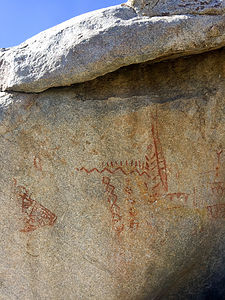 Pictographs on Pictograph TrailFor our last day in Anza-Borrego we decided to explore Blair Valley, south of California Route 78 along County Road S2.
We turned in at the sign for the Blair Valley Campground and continued on a dirt road through a lovely valley. It was a beautiful spot to set up camp. We drove 5 ½ miles, following the signs for the Pictograph Trail.
From the trailhead, the trail lead up through some lovely desert terrain. Very shortly after the trail began to descend (about a half mile from the trailhead), we encountered a large boulder on the right side of the trail with some faded red symbols painted on its north face. Although the meanings of the pictographs is not known, we do know that it was painted by the Kumeyaay Indians, who lived in the Anzo-Borrego Desert over two thousand years ago.
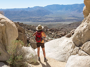 Views of Vallecito Valley from the end of the Pictograph TrailAfter he pictographs, we continued on through the wash, seeking the panoramic views our hiking book promised at the end. After about a mile, we came to an area where we were surrounded on three sides by tall rock walls. I thought at first that we had come to a dead end, but then we saw that the trail bent to the right, passing through a narrow canyon.
We entered the canyon and before long we were standing at the brink of a dry waterfall with a 150 foot dropoff below. From the edge we had a panoramic view of the far off mountains and the Vallecito Valley.
From there, we retraced our steps back out to the trailhead and the return drive through lovely Blair Valley.
Yesterday had been so action-packed that Herb very much wanted some downtime today to just sit in the sun and read. We thought it might be nice to drive out on another 4WD road and set up beach chairs in a scenic spot.
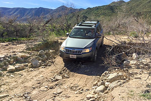 Oriflamme CanyonSince we were already down along S2, Herb chose the drive up Oriflamme Canyon, rated in our guidebook as a little more challenging than the roads we had driven on to date. I tried not to let the description freak me out -- loose rock, narrow shelf segments, possible rock fall, steep ascents and descents through switchbacks.
They were right, and we had to do a bit more rock crawling than we would have liked. There were several spots where I even got out of the Subaru to either move rocks out of the way or build ramps out of them. Finally, at about the 2 mile point we figured that this was not exactly the relaxing way we wanted to spend our last day, so we did an 18-point turn and returned to the joys of asphalt.
I felt really bad for Herb, because I had really been torturing him the entire time at Anza Borrego with a very aggressive schedule. I really wanted to find him a nice place in the sun to just read. As we drove back north along 78, I frantically looked through the off-road guide for a more suitable road for us to explore.
I directed Herb to make a turn onto Pinyon Wash where we drove for a few miles before bearing right on Nolina Wash. We came to a pretty spot, parked, took out our beach chairs, and spent the next 2 hours relaxing and reading. It was so very quiet and peaceful.
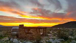 Last night at our beautiful campsiteThat pretty much wrapped up our visit to Anza-Borrego. The park is huge, but in our 6 days here we had covered a lot of ground and seen many of the recommended highlights in the park -- as Herb will attest too.
I am writing this blog about a month after our visit, and all I am seeing on the news is “Super Bloom in Anza-Borrego.” All the rain this winter has resulted in one of the most beautiful displays of wildflowers in decades. That would have been something to see.
Description
 Borrego Palms OasisWith over 600,000 acres, Anza Borrego is the largest state park in the California state park system and the largest desert state park in the U.S. Its spectacular and undeveloped Colorado Desert scenery extends from the edge of the coastal mountains east to the Salton Sea and south almost to the Mexican border. The park is located about 2 hours northeast of San Diego
The elevation in the park ranges from just 200 feet near the eastern edge to 6,200 feet, resulting in a variety of ecosystems and a temperature range as high as 30 degrees.
Major activities in the park include:
- Four-wheel driving on its nearly 500 miles of dirt and rocky roads (of varying difficulty)
- Mountain biking along those same four-wheel drive trails
- Hiking along its 50 miles of trails with a variety of scenery palm oases, waterfalls, slot canyons, badlands, desert gardens, etc.
- Wildlife viewing - bighorn sheep, deer, bobcats, coyotes, mountain lions, Jackrabbits, desert cottontails, 50 species of lizards and snakes, hawks, etc.
- Enjoying the spring wildflowers
- Camping – there are 12 campgrounds inside the park, but it is one of the few California parks that allows open camping throughout its 600,000 acres
 Layer Cake formation in Fish Creek WashThe small town of Borrego Springs lies at the center of the park and has ample services – lodging, restaurants, gas, grocery store, etc.
The park’s Visitor Center and the Borrego Palms Campground are just 5 miles west of the town of Borrego Springs. Be sure to pick up a copy of their ‘At Home’ magazine, which is a great source of things to do in the park.
- ‹ previous
- 4 of 7
- next ›
Anza-Borrego State Park location map in "high definition"
Javascript is required to view this map.
