- Home
- About
- Map
- Trips
- Bringing Boat West
- Migration West
- Solo Motorcycle Ride
- Final Family XC Trip
- Colorado Rockies
- Graduates' XC Trip
- Yosemite & Nevada
- Colorado & Utah
- Best of Utah
- Southern Loop
- Pacific Northwest
- Northern Loop
- Los Angeles to NYC
- East Coast Trips
- 1 Week in Quebec
- Southeast Coast
- NH Backpacking
- Martha's Vineyard
- Canadian Maritimes
- Ocracoke Island
- Edisto Island
- First Landing '02
- Hunting Island '02
- Stowe in Winter
- Hunting Island '01
- Lake Placid
- Chesapeake
- Provincetown
- Hunting Island '00
- Acadia in Winter
- Boston Suburbs
- Niagara Falls
- First Landing '99
- Cape Hatteras
- West Coast Trips
- Utah Off-Roading
- Maui
- Mojave 4WD Course
- Colorado River Rafting
- Bishop & Death Valley
- Kauai
- Yosemite Fall
- Utah Off-Road
- Lost Coast
- Yosemite Valley
- Arizona and New Mexico
- Pescadero & Capitola
- Bishop & Death Valley
- San Diego, Anza Borrego, Joshua Tree
- Carmel
- Death Valley in Fall
- Yosemite in the Fall
- Pacific Northwest
- Utah Off-Roading
- Southern CA Deserts
- Yosemite & Covid
- Lake Powell Covid
- Eastern Sierra & Covid
- Bishop & Death Valley
- Central & SE Oregon
- Mojave Road
- Eastern Sierra
- Trinity Alps
- Tuolumne Meadows
- Lake Powell Boating
- Eastern Sierra
- Yosemite Winter
- Hawaii
- 4WD Eastern Sierra
- 4WD Death Valley +
- Southern CA Deserts
- Christmas in Tahoe
- Yosemite & Pinnacles
- Totality
- Yosemite & Sierra
- Yosemite Christmas
- Yosemite, San Diego
- Yosemite & North CA
- Seattle to Sierra
- Southwest Deserts
- Yosemite & Sierra
- Pacific Northwest
- Yosemite & South CA
- Pacific Northwest
- Northern California
- Southern Alaska
- Vancouver Island
- International Trips
- Index
- Tips
- Books
- Photos/Videos
- Search
- Contact
Morro Bay State Park and San Luis Obispo, CA
Monday, February 6, 2017 - 1:15pm by Lolo
327 miles and 6.5 hours from our last stop - 1 night stay
Travelogue
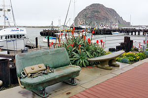
 Street Art in Morro BayThis might sound totally unrelated to a travel website, but I have been trying to find indoor wicker chairs for our sunroom, but can only find them online. Herb absolutely refuses to buy an expensive chair that he hasn’t sat in and approved for comfort, so our sunroom has stood empty for almost a year.
Finally, I got my hands on a Ratana indoor wicker furniture catalog and called the manufacturer to ask where I could sit in one. After providing my zip code, I was told San Luis Obispo, about 5 hours south of us along US 101.
“How about taking the coast route to Anza-Borrego?” I asked Herb. “I5 is so boring.”
So, we made our first day’s destination Morro Bay State Park, a park we had visited in the past. Between the beautiful harbor and estuary, quaint waterfront, and iconic Morro Rock, there is so much here to make for an enjoyable visit. Kayaking to Morro Rock has been something on our list for quite some time. Unfortunately, however, like our last visit, the weather was thwarting us again. Undaunted, we would try to make the most of it.
The weather was pretty dreary when we arrived, but since it wasn’t raining, we decided to take a walk on the Marina Boardwalk just across the way. This trail, which is quite new (built in 2012), leads from the south side of the marina parking along the estuary for about a mile. It was quite lovely.
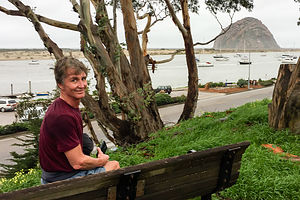
 Herb and Morro RockThe next morning was cloudy, but still no rain to speak of, so we donned our sneakers and set off for a run, once again along the Marina Boardwalk trail, and then along the harbor towards Morro Rock, a huge volcanic plug rising 576 feet above the Bay at the entrance to the harbor.
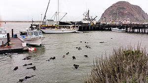
That damn rock is so big that it fooled us into thinking we were close. After 3 miles, the sky began to darken, and we were still a good distance from the rock. We decided to just go a little further to a marina before turning back. I am so glad we did, because we came upon a romp (I looked that one up) of otters playfully floating on their backs, resting their cute little heads on each other’s bellies, and I swear, smiling at us. What a life!
I’m still disappointed that we didn’t make it to the rock though, especially after reading that you can climb 400 steps to the top of it. Maybe next time.
On our way south, we stopped at the furniture store in San Luis Obispo that carried the indoor wicker chairs we were interested in, and found them to be just what we were looking for. To celebrate we went to lunch at the Firestone Grill, known for their tri-tip sandwiches and great beer.
Rainy days can be fun after all.
Description
Morro Bay State Park
 A Romp of Otters in Morro BayMorro Bay State Park is located on Morro Bay, 15 miles northwest of San Luis Obispo along scenic Highway 1. There is a 95-site campground in the park, 27 of which have partial hookups.
The most prominent feature in the area is Morro Rock, a 576 foot high volcanic plug that stands at the entrance to the harbor. This is one of nine “morros” or volcanic peaks that form a chain between Morro Bay and San Luis Obispo. There is a short causeway connecting the rock with the shore, but climbing on the rock itself is prohibited, because it is a reserved for the endangered peregrine falcon.
The calm waters of the bay are perfect for fishing, kayaking, and birdwatching. There are more than 15 miles of protected waters in the beautiful Morro Bay Estuary / Bird Sanctuary, which is home to California sea lions, harbor seals, sea otters, brown pelicans, and peregrine falcons.
The most popular hike in the park is to the 640-foot summit of Black Hill, one of the nine morros, from which there are spectacular views of Morro Bay and the nearby hills of Montana de Oro.
San Luis Obispo
San Luis Obispo is located at the junction of Highway 1 and US 101. Sometimes referred to as a “little Santa Barbara,” It is tucked into the mountains about halfway between Los Angeles and San Francisco.
Like many other towns and cities in California, San Luis Obispo was first established as a Spanish mission by Spanish Franciscan friars in 1772. Today the Mission San Luis Obispo de Tolosa is still an active church. The former friars’ quarters is now a small museum with artifacts from the Chumash Indians and the early Spanish settlers.
Today, the town’s main appeal is its charming, pedestrian-friendly downtown, with fine shops, galleries, and restaurants. Mission Plaza, with its brick paths and park benches along a creek, serves as the town square, often hosting festivals and concerts. During the school year the town bustles with students from California Polytechnic State University, more popularly known as Cal Poly.
- 1 of 7
- next ›
Morro Bay State Park and San Luis Obispo location map in "high definition"
Javascript is required to view this map.
