- Home
- About
- Map
- Trips
- Bringing Boat West
- Migration West
- Solo Motorcycle Ride
- Final Family XC Trip
- Colorado Rockies
- Graduates' XC Trip
- Yosemite & Nevada
- Colorado & Utah
- Best of Utah
- Southern Loop
- Pacific Northwest
- Northern Loop
- Los Angeles to NYC
- East Coast Trips
- Martha's Vineyard
- 1 Week in Quebec
- Southeast Coast
- NH Backpacking
- Martha's Vineyard
- Canadian Maritimes
- Ocracoke Island
- Edisto Island
- First Landing '02
- Hunting Island '02
- Stowe in Winter
- Hunting Island '01
- Lake Placid
- Chesapeake
- Provincetown
- Hunting Island '00
- Acadia in Winter
- Boston Suburbs
- Niagara Falls
- First Landing '99
- Cape Hatteras
- West Coast Trips
- Burning Man
- Utah Off-Roading
- Maui
- Mojave 4WD Course
- Colorado River Rafting
- Bishop & Death Valley
- Kauai
- Yosemite Fall
- Utah Off-Road
- Lost Coast
- Yosemite Valley
- Arizona and New Mexico
- Pescadero & Capitola
- Bishop & Death Valley
- San Diego, Anza Borrego, Joshua Tree
- Carmel
- Death Valley in Fall
- Yosemite in the Fall
- Pacific Northwest
- Utah Off-Roading
- Southern CA Deserts
- Yosemite & Covid
- Lake Powell Covid
- Eastern Sierra & Covid
- Bishop & Death Valley
- Central & SE Oregon
- Mojave Road
- Eastern Sierra
- Trinity Alps
- Tuolumne Meadows
- Lake Powell Boating
- Eastern Sierra
- Yosemite Winter
- Hawaii
- 4WD Eastern Sierra
- 4WD Death Valley +
- Southern CA Deserts
- Christmas in Tahoe
- Yosemite & Pinnacles
- Totality
- Yosemite & Sierra
- Yosemite Christmas
- Yosemite, San Diego
- Yosemite & North CA
- Seattle to Sierra
- Southwest Deserts
- Yosemite & Sierra
- Pacific Northwest
- Yosemite & South CA
- Pacific Northwest
- Northern California
- Southern Alaska
- Vancouver Island
- International Trips
- Index
- Tips
- Books
- Photos/Videos
- Search
- Contact
Death Valley National Park, CA
Tuesday, March 30, 2021 - 1:00pm by Lolo
280 miles and 7 hours from our last stop - 2 night stay
Travelogue
Along the Harry Wade Road - Saratoga Springs Marshland and Ibex Dunes
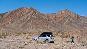 Along the Harry Wade Road to Ibex DunesWe had been to Death Valley many times and pretty much thought we knew it all, but on our last visit to the Park, Herb purchased “The Explorer’s Guide to Death Valley National Park” at the Visitor Center gift shop. We have found it to be an invaluable resource for finding the more remote and isolated gems in Death Valley.
It was from this book that Herb discovered the Ibex Dunes, located in the remote and scarcely visited southeastern part of the Park, just south of the Saratoga Springs marshland. One of the reasons it is scarcely visited is that the road to get to it is very rough and requires a 4WD vehicle with high clearance.
After leaving Barstow, we drove north of I15 and then in the town of Baker, we took Route 127 north for 30 miles to the barely obvious Harry Wade Historical Monument, and the start of the Harry Wade Road.
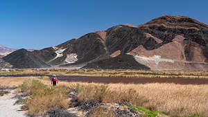 Saratoga Springs in Death ValleyWe stopped at the historical marker to read the tale of Harry Wade, who with his family and 100 other wagons, was part of the Death Valley ‘49ers, a group of pioneers from the East who foolishly tried to take a short cut through Death Valley to get to the Sutter’s Fort gold prospecting area in the Central Valley.
Well, things didn’t go so well for the party in Death Valley, which is often the case, so Harry set out and found an exit route for his ox-drawn wagon, saving his and his family’s lives. Today that exit route is known as the Harry Wade Road. It was designated a California Historic Landmark in 1957.
Well, if it was good enough for Harry, it was good enough for us, so we turned left on Harry Wade Road and drove along a well-graded road with lovely views of colorful rocks to our right. I named them “Charlie Brown” rocks because of the zig-zagging pattern of their colorful layers, similar to the shirt Charlie Brown always wore.
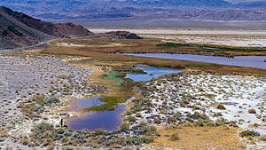 Looking down at the Saratoga SpringsAt 2.7 miles, we passed the turnoff for the Ibex Dunes (for now) and continued on to the turnoff for the Saratoga Springs marshland at mile 5.8, another lesser-known Death Valley destination that we had read about in our “The Explorer’s Guide to Death Valley National Park.” From there it was a 3.9 mile drive to the parking area.
I assume this area was named for the more famous Saratoga Springs in New York, but the similarities ends with the fact that they both have springs. The New York version doesn’t even have any pupfish inhabiting its spring.
The Death Valley version is an extremely isolated and lovely marshland, set at the base of a colorful brown, tan, and white rock formation. It is home to the Saratoga Springs pupfish, or Cyprinodon nevadensis to be exact, one of nine pupfish species that have evolved separately in the springs of Death Valley and the Owens Valley, and the first to have been discovered.
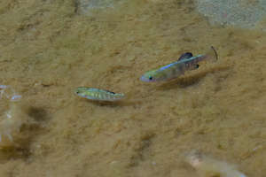 Saratoga Springs pupfishWe set off first to walk along the left side of the marsh, hoping to get close enough to the pools to see some of its inhabitants. However, the shrubs along its edge were too thick and wet to get to the water’s edge.
We noticed a road leading up the side of the interesting, colorful rock formation on the other side of the marsh, so we headed back to where we started and headed to the right side of the marsh, this time finding that we could actually get down to a small beach at the water’s edge.
Herb spent the next hour stalking the little fellas with his 100-400mm telephoto lens, which he later renamed his “pupfish” lens. He hoped to catch them in the act of mating, but apparently they weren’t in the mood right now.
Afterwards, we walked up the road along the end of the rock formation where there was a lovely view of the marshland below.
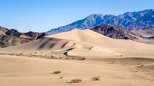 Ibex DunesWe drove back out to the Harry Wade Road and retraced our route back for about 3 miles to the Ibex Junction and turned left onto a rocky but very passable road. I don’t know how, but after we had driven about 5 or 6 miles, I glanced down at my phone where I had marked the Ibex Dunes, and saw that we had gone too far. How the heck had we missed it.
We got out of the car and looked back down the road towards the east and there they were. We debated whether or not we should just start hiking to them from here, but we would have had to do a lot of navigating through sagebrush and crossing over of dried shallow washes. There really is no one set trail to the dunes. You just have to find some good terrain, set your sight on your goal, and start hiking towards it.
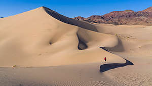 Ibex DunesI hit Find Directions on Google Maps and it indicated that we could start walking towards the dunes from a point on the road about a mile and a half back. We drove back towards that point and sure enough there was a sandy road leading to the dunes. However, it was blocked by a sign that said “Wilderness Restoration - Foot and Horse Traffic Only,” where there was room to park our truck.
As we set off on foot towards the dunes, we noticed several tire tracks from vehicles that had chosen to disregard the sign and find a way around it.
Of course we had timed our hike with the golden hour, and the dunes were starting to put on their evening show, as their dull monotone tans turned to bright beige with deep shadows in their nooks and crannies. The Saddle Peak Hills behind them did their part and took on a reddish glow.
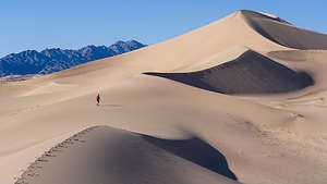 Ascending the Ibex DunesIbex Dunes might not be the tallest in Death Valley - that honor goes to the Eureka dunes - but I do think they very well might be the most stunning.
There are two distinct sections to the dunes. The ones on the left (north) are higher, while those on the left have a scattering of smaller ones leading more gently along the ridge to the top. We hiked in the direction of the one at the very right end, which was also the most brightly lit, but switched directions when the one to the left of it assumed that honor. It felt like we were racing the ever changing light.
As we got closer, we noticed some structures just south of the dunes, which we later learned was an abandoned talc mine. Perhaps that was the reason for the old road. It was interesting to see the juxtaposition of man-made structures with such a pristine natural setting.
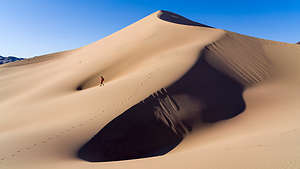 Ibex DunesDeath Valley has a rich mining history that went on from the 1850s through 1915, and in some cases even later. Of all the minerals and dreams of riches, borax and talc, rather than the more glamorous gold and talc, produced the most wealth, and there are old mining buildings to be found throughout the more remote sections of the park.
We would have liked to hike to the mine, but with the shortness of golden hour, we had to prioritize how we spent our time. So we picked up our pace and headed to the most beautifully-lit section of the lower dunes on the southern end and started our trek up along the ridges towards the top. An added bonus was that these dunes are so pristine and remote that there was not another footprint on them, and there probably hadn’t been any in days. We had this amazing landscape all to ourselves.
By the time we got back to the car, the sun had dipped behind the hills and the dunes had returned to their flatter monotone tan.
We spent the night camping in that parking spot. Not single car passed us the whole night.
Continuing along the Harry Wade Road - Salt Creek and Eureka Dunes
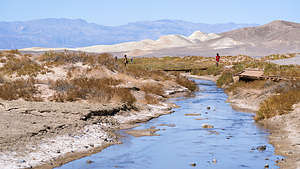 Salt Creek TrailRather than drive back out to Route 127 and take the asphalt route up and into Death Valley, we decided to continue along the Harry Wade Road which led north for another 30 or so bumpy miles before merging into the paved Badwater Road.
We drove right past Badwater Basin, as it was crowded and we had been there several times in the past, and continued north with our final planned destination for the day being the Eureka Dunes.
After stopping for gas (a very important thing to think about in Death Valley, we stopped at Salt Creek to see if we could see another one of Death Valley’s pupfish species, the Salt Creek pupfish, more formally known as Cyprinodon salinus.
There is a mile-long Interpretative Trail that traces the creek, providing information along the way about this unique habitat and the tiny, yet hardy, fish that call it home. These little 2-inch fish are found nowhere else on Earth.
.thumbnail.jpg) Herb stalking a pupfishSalt Creek is a remnant of an ancient freshwater lake that once covered much of Death Valley, but dried up about 10,000 years ago. Over the millennia the creek gradually changed from freshwater to saltwater due to the continuous evaporation of its shallow water each summer, thereby concentrating its salts. Along the way, the hardy little pupfish evolved to survive in its changing environment.
Herb stalking a pupfishSalt Creek is a remnant of an ancient freshwater lake that once covered much of Death Valley, but dried up about 10,000 years ago. Over the millennia the creek gradually changed from freshwater to saltwater due to the continuous evaporation of its shallow water each summer, thereby concentrating its salts. Along the way, the hardy little pupfish evolved to survive in its changing environment.
Today the Creek is a seasonal stream, forming pools during the spring, where in the heat of the summer, the pupfish can hunker down and go dormant when the main creek runs dry. Then when it rains and their habitat expands, they wake up and come out again.
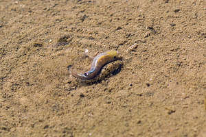 Salt Creek pupfish working on specie survivalFortunately, we were here during their active season, so we were lucky enough to observe some performing their courtship ritual, which is quite fascinating.
We could tell which ones were the males because they are luminescent yellow, purple and blue, in order to attract the rather bland-looking tan-colored ladies and let them know they are interested and ready to breed. The males are quite territorial and aggressive, chasing other males away from their turf, while simultaneously trying to entice a female into his turf.
Once he has lured one in, they cuddle up beside each other, form an s-shape, and start to wiggle. During this wiggle, the female releases an egg and the male releases sperm, which immediately fertilizes the egg. Sometimes, the female hangs around for another round. The fertilized eggs take about 10 days to hatch. A single female typically lays somewhere between 50 and 800 eggs in a single season.
Life is short for the Salt Creek pupfish, usually just one year, so they have to make the most of it.
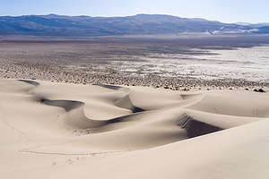 Eureka DunesAfter a picnic lunch in the Salt Creek parking lot, we set out for our next and final destination of the day - the Eureka Dunes. We continued driving north towards Scotty’s Castle, which unfortunately is still closed from the damage done during a 2015 flood when the area received close to its annual average rainfall in just five hours.
At the junction for Scotty’s Castle/Ubehebe Crater, we took a left towards the crater. Actually, we had no choice as the road to Scotty’s Castle was so damaged by storms that it is closed, and expected to be so for quite some time. Rather than going all the way to the crater, at about 2.8 miles after the junction we turned right onto the Death Valley / Big Pine Road.
The dirt-and-gravel Big Pine Road is well-maintained and definitely navigable for a 2WD vehicle. At about the 18 mile point, we came to our first landmark – Crankshaft Junction, named for the castoff engine parts that less-fortunate travelers left at this remote site. It made you think a little bit.
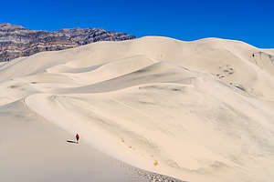 Ascending the Eureka DunesWe continued on for another 12 miles before turning left onto the South Eureka Road to the dunes. From there, it was another 10 miles along the 4WD South Eureka Road to the primitive campground near the base of the impressive Eureka Dunes. At 700 feet, it is the largest dune in California and the second largest in the entire U.S.
The campground was dry (no water or flush toilets) and had only four designated sites, all of which were already taken. Thankfully, further down the road there were more dispersed campsites, so we grabbed one not far past the official primitive one, with the outhouse. Last time we were here, there were only 3 other campers in the area. This time there were at least 30. I think there is a lot of pent-up demand for camping during the pandemic.
Late March/Early April is a great time to visit the dunes, because even in the afternoon it is usually not too hot to hike them. Around 4:00, we set off towards the northern end of the dune and then started our slog up. I always find hiking in deep sand so grueling - 2 steps forward, 1 step back.
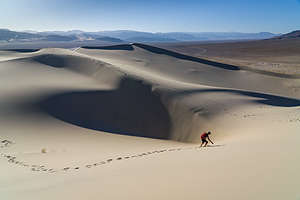 Lolo avoiding a black hole on Eureka DunesThere were portions of the hike that were so steep that I actually had to bend my body forward into the incline and use my hands as well. I looked like a gorilla. Meanwhile, each step on the really steep parts set off what looked like a river of sand, starting about 3 feet above us and continuing right below us for another dozen or so feet. The patterns we created were beautiful.
Besides the intriguing visual effect, we were also making the dunes “sing.” Singing sand dunes are quite rare and there are only about 40 of them in the entire world. The singing is really more of a booming sound, and it is triggered by an avalanching movement of sand.
It was actually a little tricky finding the summit, as each time we climbed to the top of a ridge, we saw another one higher. We had reached the summit on our last visit, but as we were now cutting into cocktail hour, we declared victory on the ridge below the summit and started the much more fun trek down. I felt like I was running down a hill of pudding. All in all, the hike was a very rewarding, and exhausting, 2 mile round-trip.
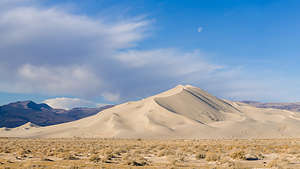 Eureka Dunes in morning lightBack at our campsite, we made dinner, sipped wine, and watched the sunset.
Before leaving the next morning, we got in the truck and drove to the southern end of the dunes, which was just starting to be lit by the early morning sun. We didn't even have our coffee yet. Behind them were the equally impressive colorfully striped limestone walls of the Last Chance Mountains, which rise 4,000 feet above the valley floor.
This was an exciting day for us. We were headed to Bishop later today where we would see our son Andrew and his wife Celeste for the first time in 5 months. An overabundance of caution during the pandemic had kept us apart. Today they were going to get some pretty long hugs.
Description
In 1994, the Desert Protection Act added an additional 1.2 million acres to Death Valley National Monument and upgraded its status to National Park, making it the largest national park outside of Alaska. The park is located on the eastern border of a remote section of California with some small portions extending into Nevada. Despite its remoteness, it is one of the most highly visited parks in the national park systems. Many of these visitors come all the way from Europe and Japan to experience the extremes of this stunningly beautiful desert.
Death Valley received its name from the unfortunate forty-niners who were forced to cross the burning sands here in order to avoid the severe snowstorns in the nearby Sierra Nevada on their way to the California Gold Rush. Many perished along the way, and those that survived remembered it as a place of suffering and death. The current names of many of the places in Death Valley reflect its harshness: Dead Man Pass, Funeral Mountains, Furnace Creek, Hell’s Gate, Devil’s Golf Course, Starvation Canyon, etc.
The valley itself is over 130 miles long, but only about 12 miles wide, flanked on both sides by unvegetated reddish mountains. From an elevation of about 3,300 feet in the north, the land slopes steadily downward to an elevation of 279 feet below sea level at Badwater, the lowest point in the western hemisphere. In fact, 70 miles of the desert floor is below sea level, accounting for its extremely high termperatures, which can exceed 130°F in summer.
In many ways, not much about the valley has changed since the pioneers first crossed here. Its intense heat, frigid cold, and the driest air imaginable still make it one of the most inhospitable locations on earth. However, today’s visitors can enjoy Death Valley and see most of its highlights from the comfort of their air conditioned cars and stay in comfortable, and even luxurious, hotel rooms at night.
The park is criss-crossed by a network of roads, ranging form washboard dirt ones to paved, well-maintained highways, making the most popular destinations quite accessible. The Furnace Creek Visitor Center, near the center of the park, is a great place to get oriented and to begin an exploration of Death Valley. This greenness of this area is a surprise to most visitors who come to the park expecting to see nothing but miles and miles of sand. Fed by warm springs, this area is a verdant oasis with palm trees as tall as 50 feet. There are also two world-class resorts here: the elegant Furnace Creek Inn and the more down-to-earth Furnace Creek Ranch.
Highlights traveling south from Furnace Creek on Route 190
- About 5 miles south of the Furnace Creek Visitor Center is Zabriskie Point, one of the most spectacular overlooks in the park. A short walk uphill from the parking lot brings you to a panoramic view of Golden Canyon and the surrounding vibrantly colored badlands. The views are particularly stunning in the lowlight of early morning or late afternoon.
- Another 1.5 miles down the highway s the turnout for Twenty-Mule Team Canyon road, a one-way dirt road that rejoins the highway in 2.7 miles. The road winds through Twenty-Mule Team Canyon with close-up views of the same colorful badlands seen from Zabriskie Point. RVs and trailers are not allowed on this road.
- 4.5 miles further south on 190 is a turnoff for Dante’s View (restricted to vehicles less than 25 feet). The road to Dante’s View climbs steeply to an overlook 5,000 feet above the valley floor, where the temperatures average 20° F cooler than in the valley. From this viewpoint, which most consider the most breathtaking in the park, one can see the lowest point (Badwater) and the highest point (Telescope Peak) in the park.
Highlights traveling south from Furnace Creek on Badwater Road
- About 1.8 miles south of the Visitor Center is the turnoff for Badwater Road. 1.5 miles further south on Badwater Road is the parking lot for the popular hike into Golden Canyon. A well-marked nature trail (2 miles RT) leads into the narrow canyon, wedged in by eroded cliffs and the slopes of golden badlands.
- Back on Badwater Road, continue south past Artist Drive (get that on the way back as it is a one-way road going north). Around 9 miles south of Golden Canyon is the turnoff for the unpaved spur road to Devil’s Golf Course. The road leads to an odd and forbidding landscape created by salt and erosion on a lake bed that dried up 2,000 years ago. The result is a jagged terrain of salty white miniature mountains and spires, less than 2 feet high. The name comes from the feeling that “only the devil could play golf on such rough links.”
- About 8 miles south is the Badwater Basin, the hottest and lowest point in Death Valley accessible by car. Surprisingly, its permanent spring-fed pools also make it one of the wettest. Legend says that it got its name from a surveyor whose mule refused to drink it. Although not poisonous, it is similar in composition and taste to Epsom salts. Despite its apparent inhospitableness, it is home to water beetles, insect larvae, and a soft-shelled saltwater snail that slowly adapted to these conditions.
- Turning back north on Badwater Road towards Furnace Creek, in 8 miles you come to the turnout for the one-way, 9-mile paved Artist Drive, which winds through a colorful display of sedimentary and volcanic rock hidden from the main road. It received its name from the rainbow of colors—red, pink, yellow, orange, and brown—that paint these rocky hills. About half-way through the loop is the parking lot for Artists Palette, one of the most colorful areas along the loop. Artist Drive is restricted to vehicles less than 25 feet.
Highlights traveling north from Furnace Creek on Route 190
- About 1.7 miles north of the Furnace Creek Visitor Center are the remains of what was once the Harmony Borax Works. Borax, which the prospectors called “white gold,” was once a big business in Death Valley. In the 1880s, Chinese laborers were hired to rake borax “cottonballs” from the valley floor and bring them to the Harmony Borax works to be purified. From there the refined borax was loaded onto the famous twenty-mule team wagons and transported 165 miles across the desert to the train station in Mojave. From there it was shipped to processing plants where it was used to make soaps, disinfectants, and food preservatives. Between 1883 and 1927, more than $30 million worth of borax was produced in Death Valley. A short trail leads past the ruins of the old borax refinery and some outlying buildings. More information on the mining of borax in Death Valley is available in the Borax Museum at the Furnace Creek Ranch.
- 12 miles further north on 190 is the turnoff for the 1.2 mile gravel road to Salt Creek, home to the famous Death Valley pupfish. When the lake that once covered Death Valley dried up thousands of years ago, the desert pupfish was the only fish that managed to adapt to the harsh conditions here. Isolated from each other in scattered salty pools, springs, and creeks, nine types of pupfish have evolved. A tenth has already become extinct. They are found no place else on earth. The pupfish can often be seen from the short wooden boardwalk nature trail that crisscrosses the stream and marshes.
- About 21 miles north of the Visitor Center, Highway 190 turns west towards Stovepipe Wells and the west entrance to the park. At this point, you can either continue on 190 or head north on the North Highway another 32 miles to Scotty’s Castle, the major man-made attraction in Death Valley.
Highlights along the North Highway (traveling north)
- The drive to Scotty’s Castle on the North Highway is a very scenic one with desert stretching out on the west and mountains rising to the east. About 10 miles north on the North Highway is a pullout with great views of Death Valley’s renowned alluvial fans. These fans are something like an hourglass with debris from the mountains funneling through a narrow opening and spilling out in a wedge shape into the valley. They come in many shapes and sizes. The ones near this viewpoint are smaller and steeper.
- 25 miles further north in the remote Grapevine Canyon looms the unlikely sight of a Moorish Castle. Construction of what was more officially called Death Valley Ranch was begun in 1922 by Chicago millionaire Albert Johnson, whose doctors had advised him to spend more time in a warm, dry climate. However, the mansion is known as Scotty’s Castle, named after Johnson’s unlikely friend, Walter Scott. Walter Scott was a cowboy that had traveled with Buffalo Bill’s Wild West Show in the 1880s before taking up prospecting. Albert Johnson was one of Scotty’s gullible investors in his “secret gold mine” in Death Valley. After several trips west to see the mine, Johnson realized that he was being duped by Scotty. Despite that, Johnson truly enjoyed his new friend and the tall tales he told. Scotty helped Johnson conceive the idea of this vacation villa in Death Valley and lived in it after Johnson’s death.
- In 1970, Scotty’s Castle was purchased by the National Park Service from the foundation to whom Johnson had willed it. Today the colorful history of the castle is brought to life by rangers dressed in 1930s clothing that welcome you as if you were Scotty’s guests. The one-hour guided tour is excellent, both for its inside look at this unusual mansion as well as for the stories about the eccentricities of the two men that built it. Tours depart every 20 minutes from 9 am to 5 pm. Plan to arrive early because they fill up quickly.
- About 1.5 miles down Grapevine Canyon heading back south on the North Highway is the turnoff for the 8 mile road to Ubehebe Crater. This half-mile wide, 600-foot deep crater was formed by volcanic explosions several thousand years ago. Dark cinders and volcanic fragments cover the surrounding countryside. From the parking area there is a steep trail up to the crater’s rim. Be prepared to battle some very gusty winds.
- Because of its remote location, few visitors get to see the famous Death Valley Racetrack, where rocks mysteriously move across the dry lakebed on their own accord. Although no one has actually seen the rocks move, they are known to move because of the trails they leave behind them. After studying the phenomenon for decades, scientists now believe they have solved the mystery. The surface of the lakebed is a fine clay that becomes very slippery when wet. After a rain, heavy winds as high as 70 mph blow the rocks across the slick surface. A 4-wheel drive vehicle is needed to reach the Racetrack, which is 27 miles past Ubehebe Crater on a rough dirt road.
Highlights traveling west along Route 190 from the junction with the North Highway
- Just west of the junction is the parking area for the surrealistic Devil’s Cornfield. On both sides of the road are odd-looking clumps of brush four to ten feet tall that resemble corn stalks. They are actually arrowweed bushes, whose stems were used by Native Americans to make arrow shafts.
- A few miles further west on 190, pull over on the shoulder by a roadside display where the Sand Dunes come close to the highway. These are the highest of a 14-square-mile field of dunes. Although there are no trails to follow, hikers are free to roam the dunes on their own. The best time of day to visit the dunes is in the morning or late afternoon when the temperatures are cooler and the lighting is more dramatic.
- Two miles further west is the village of Stovepipe Wells, Death Valley’s first tourist resort. The village actually got its name from an historic site about 5 miles north where an old stovepipe was sunk into the sand to form the shaft of a well. For years this well was used by travelers as a source for water. Around 1926 a developer planned to build a small resort near the well. However, his lumber trucks got stuck in the sand before he could reach it. Rather than unload and reload his trucks, he decided to try and dig a well where they were. They struck water and stayed. That spot is the current location for Stovepipe Wells. Today the village has a motel, general store, saloon, restaurant, and campground.
Campgrounds that will accomodate RVs in Death Valley
- Furnace Creek Campground (136 sites, no hookups) – located just north of the Visitor Center. Open year round. This is the only park campground that takes reservations.
- Mesquite Spring Campground (30 sites, no hookups) – located 5 miles south of Scotty’s Castle. Open year round.
- Panamint Springs Resort (40 sites, 12 hookups) – located 30 miles west of Stovepipe Wells on Route 190. Open year round. This campground is privately operated and takes reservations.
- Stovepipe Wells Campground (200 sites, 15 hookups) – located in the village of Stovepipe Wells. Open year round.
- Sunset Campground (1000 sites, no hookups) – located .25 miles east of the Furnace Creek Ranch. Open October through April.
- Texas Spring Campground (92 sites, no hookups) – located near Sunset Campground. Open October through April.
- Wildrose Campground (30 sites, no hookups) – located 30 miles south of Stovepipe Wells off the Trona-Wildrose Road. Open year round.
In addition to the park campgrounds, there are two privately-owned campgrounds in the park:
- Furnace Creek Ranch Campground (26 sites, all full hookups) - located at The Ranch just south of the Visitor Center. Open year round. Guests can enjoy the Ranch’s natural spring-fed swimming pool, shower facility, coin operated laundry, tennis courts, shuffleboard, volleyball, Bocci Ball and basketball court.
- Panamint Springs Campground (37 sites, 12 full hookups) - located at the western end of Death Valley National Park on Highway 190 in the town of Panamint Springs
- ‹ previous
- 7 of 9
- next ›
Death Valley National Park location map in "high definition"
Javascript is required to view this map.
