- Home
- About
- Map
- Trips
- Bringing Boat West
- Migration West
- Solo Motorcycle Ride
- Final Family XC Trip
- Colorado Rockies
- Graduates' XC Trip
- Yosemite & Nevada
- Colorado & Utah
- Best of Utah
- Southern Loop
- Pacific Northwest
- Northern Loop
- Los Angeles to NYC
- East Coast Trips
- Martha's Vineyard
- 1 Week in Quebec
- Southeast Coast
- NH Backpacking
- Martha's Vineyard
- Canadian Maritimes
- Ocracoke Island
- Edisto Island
- First Landing '02
- Hunting Island '02
- Stowe in Winter
- Hunting Island '01
- Lake Placid
- Chesapeake
- Provincetown
- Hunting Island '00
- Acadia in Winter
- Boston Suburbs
- Niagara Falls
- First Landing '99
- Cape Hatteras
- West Coast Trips
- Burning Man
- Utah Off-Roading
- Maui
- Mojave 4WD Course
- Colorado River Rafting
- Bishop & Death Valley
- Kauai
- Yosemite Fall
- Utah Off-Road
- Lost Coast
- Yosemite Valley
- Arizona and New Mexico
- Pescadero & Capitola
- Bishop & Death Valley
- San Diego, Anza Borrego, Joshua Tree
- Carmel
- Death Valley in Fall
- Yosemite in the Fall
- Pacific Northwest
- Utah Off-Roading
- Southern CA Deserts
- Yosemite & Covid
- Lake Powell Covid
- Eastern Sierra & Covid
- Bishop & Death Valley
- Central & SE Oregon
- Mojave Road
- Eastern Sierra
- Trinity Alps
- Tuolumne Meadows
- Lake Powell Boating
- Eastern Sierra
- Yosemite Winter
- Hawaii
- 4WD Eastern Sierra
- 4WD Death Valley +
- Southern CA Deserts
- Christmas in Tahoe
- Yosemite & Pinnacles
- Totality
- Yosemite & Sierra
- Yosemite Christmas
- Yosemite, San Diego
- Yosemite & North CA
- Seattle to Sierra
- Southwest Deserts
- Yosemite & Sierra
- Pacific Northwest
- Yosemite & South CA
- Pacific Northwest
- Northern California
- Southern Alaska
- Vancouver Island
- International Trips
- Index
- Tips
- Books
- Photos/Videos
- Search
- Contact
Red Rock Canyon State Park, CA
Wednesday, May 23, 2018 - 8:30pm by Lolo
407 miles and 7.5 hours from our last stop - 1 night stay
Travelogue
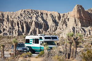 Camping in Red Rock CanyonAlthough 2 ½ hours longer, we decided to take the southern route to Bishop to avoid encountering snow along the mountain passes. I5 south to Bakersfield is a bit monotonous to say the least, but a lot less stressful than the alternatives.
Rather than go the whole way, we decided to stop for the evening at Red Rock Canyon State Park, a desert park we have not been too, known for its reddish desert cliffs, buttes, and spectacular rock formations.
The campground is first-come-first-served, and we were far ahead of the Memorial Day crowd - if there ever is one at this remote park - so we had no trouble getting a nice campsite, set against a backdrop of colorful cliffs. The sites are quite large with a lot of space between them, making for a very pleasant experience.
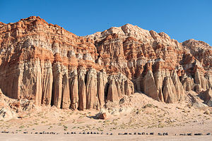 The Red Cliffs of Red Rock CanyonBefore dinner, we took a stroll around the campground loop, enjoying the colorful rock formations along the way.
The next morning, before continuing on to Bishop, we decided to do a few hikes in the park. We drove the short distance down Highway 14 to the Red Cliffs Natural Preserve, a hikers-only section of the state park.
From the parking lot we set off on the Red Cliffs trail, which was really more of an old jeep road than a trail, with great views of the 300-foot high columnar red cliffs the park is known for and the El Paso Mountains in the distance - oh, and some Joshua Trees along the way. There was a lot of scenery packed into our 2.5 mile out and back hike.
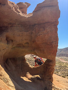 Herb peeking through window along Hagan Canyon TrailSince we had our Subaru Forester, which we now always tow behind the Lazy Daze, we thought it would be fun to do a bit of off-roading in the park. We headed out from the Red Cliffs parking lot on a dirt road through Iron Canyon, but were unable to get too far before being stopped by a gate. Much of the Scenic Cliffs area is closed each year from February 1 to July 1 to protect nesting birds of prey.
So we got back on Highway 14, drove north a bit, and took another dirt road with the hopes of getting to an overlook, marked on the map we had gotten at the Visitor Center. However, trails weren’t marked very well, so after driving for what seemed like far too long, we realized we had overshot our goal. Eventually we found our way back to Highway 14 and headed back to the campground to squeeze in one more hike before the noon-time checkout.
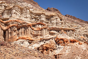 Along the Hagan Canyon TrailWe parked at the Hagan Canyon trailhead right outside the entrance to the campground. It was even shorter than the Red Cliffs hike - only 1 mile - but it too packed a lot of awesome scenery into that distance.
Many cowboy westerns were filmed amongst these beautiful sandstone cliffs and interesting rock formations, such as “Zorro Rides Again", "Law and Order" starring Ronald Reagan, "The Ten Commandments", "Jurassic Park", and "Beneath the Planet of the Apes".
Noon was quickly approaching - time to move our motorhome out of the camping site and move on towards Bishop.
Description
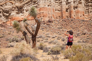 Hagan Canyon TrailRed Rock Canyon is a California state park located 120 miles north of Los Angeles, via I5 and Highway 14, where the southernmost tip of the Sierra Nevada converges with the El Paso mountain range.
The park features reddish desert cliffs and spectacular rock formations with dramatic shapes and vivid colors. Miles of hiking trails meandering through the dramatic landscape of the park. There is also a vast network of dirt primitive roads for 4WDing.
There is a first-come, first-served campground in the park with 50 primitive sites. The sites are spacious and tucked up against the base of the dramatic desert cliffs.
- 1 of 6
- next ›
Red Rock Canyon State Park location map in "high definition"
Javascript is required to view this map.
