- Home
- About
- Map
- Trips
- Bringing Boat West
- Migration West
- Solo Motorcycle Ride
- Final Family XC Trip
- Colorado Rockies
- Graduates' XC Trip
- Yosemite & Nevada
- Colorado & Utah
- Best of Utah
- Southern Loop
- Pacific Northwest
- Northern Loop
- Los Angeles to NYC
- East Coast Trips
- 1 Week in Quebec
- Southeast Coast
- NH Backpacking
- Martha's Vineyard
- Canadian Maritimes
- Ocracoke Island
- Edisto Island
- First Landing '02
- Hunting Island '02
- Stowe in Winter
- Hunting Island '01
- Lake Placid
- Chesapeake
- Provincetown
- Hunting Island '00
- Acadia in Winter
- Boston Suburbs
- Niagara Falls
- First Landing '99
- Cape Hatteras
- West Coast Trips
- Utah Off-Roading
- Maui
- Mojave 4WD Course
- Colorado River Rafting
- Bishop & Death Valley
- Kauai
- Yosemite Fall
- Utah Off-Road
- Lost Coast
- Yosemite Valley
- Arizona and New Mexico
- Pescadero & Capitola
- Bishop & Death Valley
- San Diego, Anza Borrego, Joshua Tree
- Carmel
- Death Valley in Fall
- Yosemite in the Fall
- Pacific Northwest
- Utah Off-Roading
- Southern CA Deserts
- Yosemite & Covid
- Lake Powell Covid
- Eastern Sierra & Covid
- Bishop & Death Valley
- Central & SE Oregon
- Mojave Road
- Eastern Sierra
- Trinity Alps
- Tuolumne Meadows
- Lake Powell Boating
- Eastern Sierra
- Yosemite Winter
- Hawaii
- 4WD Eastern Sierra
- 4WD Death Valley +
- Southern CA Deserts
- Christmas in Tahoe
- Yosemite & Pinnacles
- Totality
- Yosemite & Sierra
- Yosemite Christmas
- Yosemite, San Diego
- Yosemite & North CA
- Seattle to Sierra
- Southwest Deserts
- Yosemite & Sierra
- Pacific Northwest
- Yosemite & South CA
- Pacific Northwest
- Northern California
- Southern Alaska
- Vancouver Island
- International Trips
- Index
- Tips
- Books
- Photos/Videos
- Search
- Contact
South Lake Tahoe, CA
Wednesday, May 30, 2018 - 5:15pm by Lolo
104 miles and 2.5 hours from our last stop - 1 night stay
Travelogue
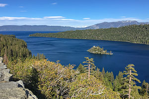 Fannette Island in Lake TahoeRather than taking the shortest route home from the Eastern Sierra through Yosemite, we usually take the more gentler (in terms of mountain passes) route up 395 to Gardnerville, Nevada and then down through South Lake Tahoe.
Since we were in no particular rush to get home, we decided to squeeze another day into our mini-vacation and spend the night in South Lake Tahoe. We called the Camp Richardson campground to see if there was room for us, but they told us that they were not open on weekdays for another week.
There was another campground right across the street from the lake a little further east that we had always been curious about. After a little bit of research, I found out that it is called Campground by the Lake and it is owned and operated by the City of South Lake Tahoe Recreation Services Department. I gave them a call and found out that they were indeed open and that they did have space for us that night.
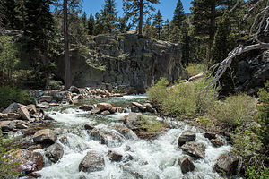 Upper Eagle FallsThe campground was quite nice and is part of a complex with other city recreational facilities, such as an indoor heated swimming pool, an ice arena, basketball courts, pickleball, etc. The day use cost to use these facilities is $6.
However, today we were doing what we had been doing every day on our trip so far - hiking.
After consulting our trusty Moon California Hiking guide, we headed over to the trailhead for the Upper Eagle Fall trailhead, 8.5 miles up Highway 89. The hike was described as the second most popular hike in the entire Tahoe region, second only to the trail to Vikingsholm, which we had already done.
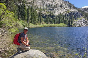 Eagle LakeIt was mid-week, so we figured it couldn’t be too crowded. Not only was the trailhead parking lot full, but cars were parked all along the highway for about ½ mile in either direction. Finally, after circling for about 10 minutes, we grabbed a spot in the parking lot for the Vikingsholm hike, paid our $10, and hiked back down the road to the start of the hike to Upper Eagle Falls.
The hike was nice, but definitely a bit of a zoo. The trail was what our guide book called a “designer” path with stairs cut out of granite and an elaborate wooden bridge crossing over the top of the falls. After the bridge, the trail got a bit rougher and climbed quite steeply to reach the rocky shores of Eagle Lake. The hike was a little over 2 miles round trip.
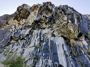 Mayhem Cove climbing cragWe had also been given the assignment by our sons to check out a climbing crag called Mayhem Cove that was reached via the Upper Eagle Falls parking lot. They do this to us a lot - “While you’re in the neighborhood, could you just see how “fill in the name” crag looks.
Fulfilling these requests usually involves bushwhacking and scrambling up rocks to reach the base of a cliff that we then study to try to find climbing routes. This one did not disappoint. We are such good parents.
The rock was like nothing we have ever seen - and we have seen a lot of climbing crags. The granite wall, which is composed of large blocks of granite, seemingly just hanging together, has big black streaks running down its otherwise pearly white surface. Water from the previous day’s rain was still seeping through the cracks between the blocks, making it unclimbable for the time being. We took several photos to submit with our report to the boys.
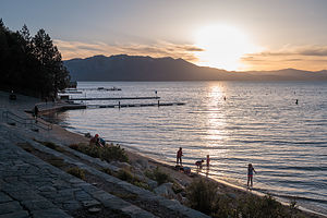 Sunset over Lake TahoeThat evening we packed a cooler with wine and cheese and walked across the street to the promenade that ran along the lake shore. The views were lovely and the group of people learning to paddle board right in front of us were quite entertaining. Apparently, it’s a lot harder than it looks.
Discovering another campground in South Lake Tahoe was a good thing. Both Camp Richardson and the Campground on the Lake had its advantages. Campground on the Lake is a shorter distance to the lake, but Camp Richardson has the Tallac Historic Site right across the street from it to wander around. Not bad having two good choices!
Description
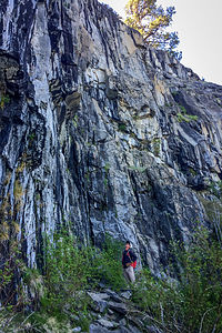 Herb contemplating Mayhem Cove climbing cragI am not even going to attempt to give a full description of what Lake Tahoe has to offer, as we only spent a short time on its southern shore.
However, briefly, Lake Tahoe is one of the highest elevation lakes (6,255 feet high) in the U.S., as well as the second deepest (1,645 feet deep) – Crater Lake is the deepest. It is located along the border between California and Nevada. The four shores of the lake are each quite different. The north is quiet and upscale, the west and east are more rugged and less developed, and the south shore is busy and tacky with neon-lit hotels and casinos. The 72-mile drive around the lake is very scenic.
Lake Tahoe is known for its clear blue and green waters and the panorama of mountains that surround it on all sides. It is a year-round destination with swimming, boating, kayaking, and various other kinds of water sports during the summer; hiking, backpacking, and camping all year round; and tremendous skiing and snowboarding in the winter.
- ‹ previous
- 5 of 6
- next ›
South Lake Tahoe location map in "high definition"
Javascript is required to view this map.
