- Home
- About
- Map
- Trips
- Bringing Boat West
- Migration West
- Solo Motorcycle Ride
- Final Family XC Trip
- Colorado Rockies
- Graduates' XC Trip
- Yosemite & Nevada
- Colorado & Utah
- Best of Utah
- Southern Loop
- Pacific Northwest
- Northern Loop
- Los Angeles to NYC
- East Coast Trips
- Martha's Vineyard
- 1 Week in Quebec
- Southeast Coast
- NH Backpacking
- Martha's Vineyard
- Canadian Maritimes
- Ocracoke Island
- Edisto Island
- First Landing '02
- Hunting Island '02
- Stowe in Winter
- Hunting Island '01
- Lake Placid
- Chesapeake
- Provincetown
- Hunting Island '00
- Acadia in Winter
- Boston Suburbs
- Niagara Falls
- First Landing '99
- Cape Hatteras
- West Coast Trips
- Burning Man
- Utah Off-Roading
- Maui
- Mojave 4WD Course
- Colorado River Rafting
- Bishop & Death Valley
- Kauai
- Yosemite Fall
- Utah Off-Road
- Lost Coast
- Yosemite Valley
- Arizona and New Mexico
- Pescadero & Capitola
- Bishop & Death Valley
- San Diego, Anza Borrego, Joshua Tree
- Carmel
- Death Valley in Fall
- Yosemite in the Fall
- Pacific Northwest
- Utah Off-Roading
- Southern CA Deserts
- Yosemite & Covid
- Lake Powell Covid
- Eastern Sierra & Covid
- Bishop & Death Valley
- Central & SE Oregon
- Mojave Road
- Eastern Sierra
- Trinity Alps
- Tuolumne Meadows
- Lake Powell Boating
- Eastern Sierra
- Yosemite Winter
- Hawaii
- 4WD Eastern Sierra
- 4WD Death Valley +
- Southern CA Deserts
- Christmas in Tahoe
- Yosemite & Pinnacles
- Totality
- Yosemite & Sierra
- Yosemite Christmas
- Yosemite, San Diego
- Yosemite & North CA
- Seattle to Sierra
- Southwest Deserts
- Yosemite & Sierra
- Pacific Northwest
- Yosemite & South CA
- Pacific Northwest
- Northern California
- Southern Alaska
- Vancouver Island
- International Trips
- Index
- Tips
- Books
- Photos/Videos
- Search
- Contact
2009 White Mountains Backpacking Trip
May 31 to June 7, 2009 by Andrew
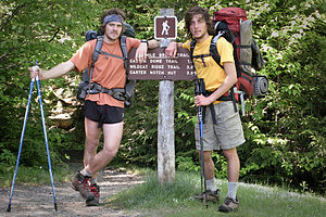
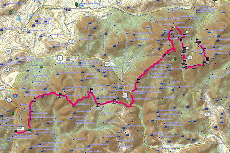
 The Hike's EndpointThis backpacking trip had been long in the making. Nik and I had been discussing, planning, and analyzing ever since we came back our previous trip to the Green Mountains last summer. Although the plan had changed several times since then--becoming somewhat less ambitious as we both began to realize that as much as we wished we could, neither of us could spare 3 ½ weeks away from society—the general concept of simple living and hiking in the woods remains the same.
With encouragement from my Dad, we finally settled on a 70ish mile section of the White Mountains on the Appalachian Trail that started south of the Presidential Range and ended a bit north of it. This trip would include all the classic peaks while still giving us a trip that qualified our definition of “hardcore”. We decided to allot ourselves 8 days, and because of the location of the trail, we decided to carry all 8 days worth of food and supplies with us, rather than try and find a place to restock. Thanks to some help from my Mom, who can’t help but give her input for any trip being planned, we established a tentative hiking mileage schedule that would bring us to an established campsite each night. The hiking schedule was fairly ambitious, but nothing too excessive. We also had options on the northern end of our trip as to where we would call it quits depending on how we felt. I couldn’t help but feel a little nervous regarding my physical abilities going into this trip, as I’ve been having some knee problems the past few months. Not only is this a problem in and of itself, but it has also left me somewhat out of shape, as I have not been able to run very much.
Despite the fact that I’ve spent the previous 10 months following my summer job at Campmor obsessing over and purchasing new “lightweight” gear, I unfortunately did not get to use most of it. This was mainly because of lack of knowledge and experience with our terrain, which left us extra cautious and wanting to be prepared for the absolute worst. We knew going into the trip that our timing wasn’t ideal – we were in the heart of both mud season and black fly season, although fortunately neither turned out to be a serious issue. However, in early June, it is still quite cold (the weather on Mt. Washington 2 days before our departure was 18 degrees Fahrenheit). Having never tested the limits of my light and compact Mountain Hardware Ultralamina 32 degree sleeping bag, I opted for the old and bulky classic – the North Face Cat’s Meow, which I had used in similar conditions comfortably. Also, not being sure of the temperature, we probably packed more clothes than necessary as well. A combo of 8 days worth of food, excessive clothing, and a bulky sleeping bag left me with no option but to sacrifice my custom fit lightweight Osprey Aether 60, for the beastly 7 pound Lowe Alpine Expedition, capable of carrying 65+ pounds – a bag I swore I’d never need.
We spent the few days before the trip testing everything out. This included setting up the tent, packing the bags, and most importantly yet most difficult, purchasing food. I left Nik to this task, and he did a great job – probably somewhat excessive in terms of quantity, but we certainly ate great. He did the shopping by calories and ended up giving us close to 4000 a day. Because of the location of our trip, we didn’t think that restocking would be feasible. Therefore we carried all 8 days worth of food with us, which made planning and packing somewhat more difficult. Breakfast was to be standard – oatmeal with dried cranberries and coffee. Lunch varied between some combo of peanut butter and jelly, nutella, and cheese. And dinner was also highly variable yet still simple – rice, pasta, beans, and 1 test-run of the somewhat overpriced Freeze Dried Backpacker Food. We also gave ourselves two “snack meals” per day, which were a Powerbar and a carefully divided bag of homemade gorp. After carefully dividing and organizing everything by day and by meal, we finally felt comfortable that we were going to be well-fed for our trip.
It was time to hit the trail.
You can download a detailed pdf Road Trip Travel Itinerary or zipped Microsoft Streets and Trips Travel Road Map file for this trip using the links shown below.

