- Home
- About
- Map
- Trips
- Bringing Boat West
- Migration West
- Solo Motorcycle Ride
- Final Family XC Trip
- Colorado Rockies
- Graduates' XC Trip
- Yosemite & Nevada
- Colorado & Utah
- Best of Utah
- Southern Loop
- Pacific Northwest
- Northern Loop
- Los Angeles to NYC
- East Coast Trips
- Martha's Vineyard
- 1 Week in Quebec
- Southeast Coast
- NH Backpacking
- Martha's Vineyard
- Canadian Maritimes
- Ocracoke Island
- Edisto Island
- First Landing '02
- Hunting Island '02
- Stowe in Winter
- Hunting Island '01
- Lake Placid
- Chesapeake
- Provincetown
- Hunting Island '00
- Acadia in Winter
- Boston Suburbs
- Niagara Falls
- First Landing '99
- Cape Hatteras
- West Coast Trips
- Burning Man
- Utah Off-Roading
- Maui
- Mojave 4WD Course
- Colorado River Rafting
- Bishop & Death Valley
- Kauai
- Yosemite Fall
- Utah Off-Road
- Lost Coast
- Yosemite Valley
- Arizona and New Mexico
- Pescadero & Capitola
- Bishop & Death Valley
- San Diego, Anza Borrego, Joshua Tree
- Carmel
- Death Valley in Fall
- Yosemite in the Fall
- Pacific Northwest
- Utah Off-Roading
- Southern CA Deserts
- Yosemite & Covid
- Lake Powell Covid
- Eastern Sierra & Covid
- Bishop & Death Valley
- Central & SE Oregon
- Mojave Road
- Eastern Sierra
- Trinity Alps
- Tuolumne Meadows
- Lake Powell Boating
- Eastern Sierra
- Yosemite Winter
- Hawaii
- 4WD Eastern Sierra
- 4WD Death Valley +
- Southern CA Deserts
- Christmas in Tahoe
- Yosemite & Pinnacles
- Totality
- Yosemite & Sierra
- Yosemite Christmas
- Yosemite, San Diego
- Yosemite & North CA
- Seattle to Sierra
- Southwest Deserts
- Yosemite & Sierra
- Pacific Northwest
- Yosemite & South CA
- Pacific Northwest
- Northern California
- Southern Alaska
- Vancouver Island
- International Trips
- Index
- Tips
- Books
- Photos/Videos
- Search
- Contact
Grindelwald , Switzerland
Tuesday, June 13, 2017 - 9:30am by Lolo
80 miles and 3 hours from our last stop - 2 night stay
Travelogue
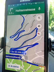 The twisty roads to GrindelwaldLet’s just say that the drive from Tasch to Grindelwald was an interesting one. We weren’t even an hour into our drive before the twisties began. We refer to them on Google Maps as intestines.
The twisties eventually straightened out and we breathed a collective sigh of relief.
One thing our sons criticize Herb and I about is our reliance on Google Maps, rather than doing it the old fashioned way with real maps and having a general idea of where we are going. Perhaps, they are right, as the following episode will illustrate.
As we were entering the town of Goppenstein, Google Maps told us to “turn left.” Herb did as he was told, and we found ourselves in a parking lot.
Somewhat confused, Herb asked me to get out of the car to help him back out so we could regroup and figure out what was going on. As I was guiding him back, he stuck his head out the window and said, “Google Maps is saying to get on the train!”
What? What train?
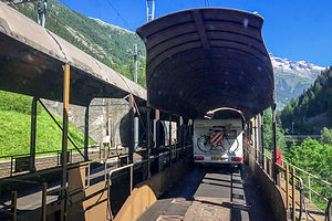 "Take the Train!"Soon we noticed other cars and even another camper drive past us through the parking lot to a ticket kiosk. That’s when we realized that this was a station for a auto-train, and that we really were supposed to “take the train.”
Rather than drive over the Bernese Alps, we were going to go right through them. We paid our 27 francs and drove onto a flat car. We spent the next 15 minutes in the dark, rather stinky Lötschberg Tunnel before popping out on the other side of the Alps in the town of Kandersteg, Switzerland. It was the best 27 francs we ever spent. I’m sure the cost of gas and antacids pills for the driver over the pass would have been more than 27 francs.
Next time we will look at Google’s proposed directions on a real map, so that we have no more surprises.
The remaining hour or so of the drive to Grindelwald was thankfully uneventful.
Day 1 - Cable Car to Mannlichen and the hike down to Kleine Scheidegg and Grindelwald
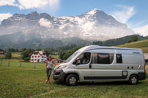 Camping EigennordwandWe were very excited to be in Grindelwald. This village had been on the top of my list of places to see from the very beginning of my trip planning. It was what I visualized when I thought “Alps.”
It was even more beautiful than I had imagined - lovely alpine chalets, verdant pastures, cowbells ringing. and best of all, the north face of the Eiger looming over our campsite. I had picked Camping Eigernordwand because of its close proximity to the Mannlichen cable car station, but had no idea that it would have the views it did. It never hit me that “Eigernordwand” meant Eiger North Wall.
We selected a site at the northern end of a grassy field, so we would have an unobstructed view of the “big fella.” We have had some very scenic campsites over the last 20 years, but this one hit the top of the list.
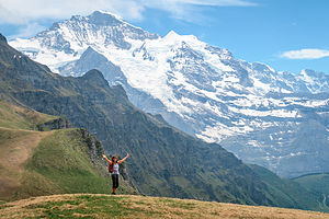 "The hills are alive" atop MannlichenOur preference probably would have been to just chill at the campground for the rest of the afternoon, but the forecast for tomorrow looked questionable, and we really had our heart set on a hike.
So, we walked to the Mannlichen cable car station, bought our tickets for 30 francs each, and spent the next ½ hour soaring through the sky, enjoying the mountain views along the way.
When we got off the cable car we walked to the top of the ridge and were treated to the most incredibly breathtaking view of mountains I have ever seen. This was turning out to be a stop full of superlatives. I wanted to burst into song.
From Mannlichen, we followed a well-traveled trail for 3 miles down to Kleine Scheidegg, with the majestic Eiger, Monch, and Jungfrau mountains laid out before us the entire way.
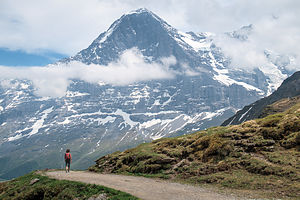 Hiking down to Kleine ScheideggAlthough the hike was one of the most scenic I have ever done, I have to admit that I was a bit disappointed with the commercialism of Kleine Scheidegg. As we approached, the scene was dominated by a large red and white tee pee with “Coca Cola” written across it, and lots and lots of tourists, who I had a feeling didn’t get here by foot, as we did.
From Kleine Scheidegg there are several options. You can take a cable car back down to Grindelwald, hike down to it, or take a 2 hour cable car up to the Jungfraujoch, a saddle between the Monch and Jungfrau with even more incredible views of the mountains, as well as the Aletsch Glacier, a UNESCO World Heritage Site. A round trip ticket to the Jungfraujoch costs about 77 francs per person, unless you have one of the many Swiss or Bernese Oberland discount cards.
It was already pretty late in the day, and we have a preference for non-touristy activities, so we chose to walk the 6 miles back down to Grindelwald. It was a lovely walk through meadows and verdant pastures, accompanied by the melody of cowbells. The cow to people ratio was easily 50 to 1 - just the way we like it.
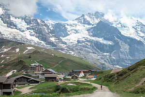 Kleine ScheideggWe were quite tired when we got back to the campground, as it had been an 8.8-mile hike with a 4,200 foot elevation loss. Elevation loss always sounds good on paper, but I find hiking down much harder on the knees and feet.
We set up our little rental table and chair outside the camper, drank a well-earned beer or two, and just gazed at our imposing neighbor, the Eiger.
After the sun went down, we noticed two bright lights on its face. At first we thought it was the headlamps of climbers camping on its face, but we later learned that it was the lights from the tunnel that was drilled through the Eiger for the Jungfraujoch train to pass through. I don’t think there is a mountain big enough to stop these Swiss from drilling through it.
Day 2 - Exploring the village of Grindelwald and Bouldering in the Sportzentrum Climbing Gym
 Lolo climbing at the Grindelwald SportzentrumWe had been smart to get our hike in yesterday, because, as we feared, the weather today was cloudy with possible rain showers in the afternoon. Since we hadn’t seen the main part of Grindelwald yet, we decided to make the mile and a half walk into town.
Our first stop in town was the Sportzentrum, a state-of-the art sports center for sports, recreation, and wellness, open to the public. It was pretty amazing. There was a swimming pool, Finnish sauna, steam room, weight room, indoor rope park, internet cafe lounge, ice rink, and boulder area, which is what we came for.
 Herb climbing at the Grindelwald SportzentrumIt cost us 21 francs each for a bouldering pass and climbing shoes. When we got to the bouldering room, which was the smallest I have ever seen, we looked at the ratings chart on the wall, which showed the color of climbs from easiest to most difficult - Yellow for kids, Orange the next easiest, then green being medium, and so on.
I joked that I would warm up on the Kids’ routes. Well, I should have known that kids that grow up in the shadow of the Eiger are tough, because these routes were far from easy for me. It was quite discouraging. Herb, did much better, of course, but even he agreed that the climbs were quite challenging.
After that we picked up groceries in the COOP and wandered back to the campground, which basically had the best view in town.
One funny, but rather embarrassing story about our food shopping in a foreign land. Herb loves to eat pastry first thing in the morning before I wake up, a habit he has had for as many years as I can remember. The COOP had no donuts or apple turnovers, so I picked up what looked like cinnamon buns.
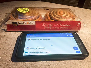 Snails in Hazelnuts??When we got back to the camper, Herb happened to read the side of the package, which said, “Schnecken aux nussfullung.” Just for fun, he looked it up on Google Translate and found that it meant, “snails in hazelnuts.”
Snails in pastry? That seemed crazy, but it wouldn’t be the first time this trip that we were surprised by different European foods and customs.
Herb was crestfallen. He has lots of food allergies, including shellfish, so he didn’t think eating snails would be a very good idea. Then it hit us. The buns were shaped like snails!
So, he ate one.
Description
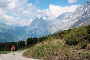 Hiking back to GrindelwaldGrindelwald is an alpine village perched in the mountains of the Jungfrau Region of Switzerland's Bernese Oberland, about 12 miles southeast of Interlaken.
This lovely village of alpine chalets and verdant pastures, set at the base of the Eiger’s north face, is one of the most popular destinations in the Alps, and it is easy to see why.
In winter it offers excellent skiing, and in the summer it serves as a great base camp for hiking. Some of the best hiking trails in the Bernese Oberlands originate here. Hikers can either start in the village or take one of the cable cars up to the high country to begin their trek.
Mannlichen Cable Car
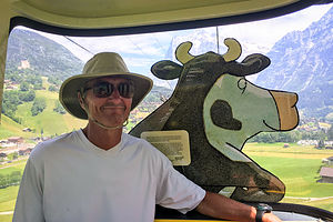 Herb on the Mannlichen Cable CarFrom the Grindelwald Grund at Grundstrasse 54, a cable car whisks hikers up to Mannlichen, where there is a fantastic panoramic view of the Eiger, Monch, Jungfrau, and more. This cable car is featured in National Geographic’s Journeys of a Lifetime.
If you have time for only one hike from Mannlichen, make it the Panoramaweg to Kleine Scheidegg. Along this 90-minute, mostly downhill walk, there is nothing but pure Alps before you. From Kleine Scheidegg you can take a train back to Grindelwald or hike 3 hours.
Another popular option from Kleine Scheidegg is to take another cable car up to the Jungfraujoch. This train, which actually goes through the Eiger to the Jungfraujoch, which is a saddle between the Monch and Jungfrau mountains. For 2 hours, The railway climbs 9 km to the Eiger Glacier Station where the views of the surrounding peaks and the Aletsch Glacier are incredible.
First Gondola
Another option for hiking in the Grindelwald area is to take the Gondola in the village up to First, where a trail leads to the Bachalpsee, a pretty alpine lake at the foot of the Faulhorn. The hike is 3.6-miles (RT) and takes about 2 to 2 ½ hours.
Also at First, is the new Cliff Walk by Tissot, a narrow metal walkway built into the side of a cliff, with a 130-foot suspension bridge and 150-foot-high viewing platform from which there are incredible views of the surrounding mountains, valleys, and pastures.
- ‹ previous
- 12 of 17
- next ›
Grindelwald location map in "high definition"
Javascript is required to view this map.
