- Home
- About
- Map
- Trips
- Bringing Boat West
- Migration West
- Solo Motorcycle Ride
- Final Family XC Trip
- Colorado Rockies
- Graduates' XC Trip
- Yosemite & Nevada
- Colorado & Utah
- Best of Utah
- Southern Loop
- Pacific Northwest
- Northern Loop
- Los Angeles to NYC
- East Coast Trips
- Martha's Vineyard
- 1 Week in Quebec
- Southeast Coast
- NH Backpacking
- Martha's Vineyard
- Canadian Maritimes
- Ocracoke Island
- Edisto Island
- First Landing '02
- Hunting Island '02
- Stowe in Winter
- Hunting Island '01
- Lake Placid
- Chesapeake
- Provincetown
- Hunting Island '00
- Acadia in Winter
- Boston Suburbs
- Niagara Falls
- First Landing '99
- Cape Hatteras
- West Coast Trips
- Burning Man
- Utah Off-Roading
- Maui
- Mojave 4WD Course
- Colorado River Rafting
- Bishop & Death Valley
- Kauai
- Yosemite Fall
- Utah Off-Road
- Lost Coast
- Yosemite Valley
- Arizona and New Mexico
- Pescadero & Capitola
- Bishop & Death Valley
- San Diego, Anza Borrego, Joshua Tree
- Carmel
- Death Valley in Fall
- Yosemite in the Fall
- Pacific Northwest
- Utah Off-Roading
- Southern CA Deserts
- Yosemite & Covid
- Lake Powell Covid
- Eastern Sierra & Covid
- Bishop & Death Valley
- Central & SE Oregon
- Mojave Road
- Eastern Sierra
- Trinity Alps
- Tuolumne Meadows
- Lake Powell Boating
- Eastern Sierra
- Yosemite Winter
- Hawaii
- 4WD Eastern Sierra
- 4WD Death Valley +
- Southern CA Deserts
- Christmas in Tahoe
- Yosemite & Pinnacles
- Totality
- Yosemite & Sierra
- Yosemite Christmas
- Yosemite, San Diego
- Yosemite & North CA
- Seattle to Sierra
- Southwest Deserts
- Yosemite & Sierra
- Pacific Northwest
- Yosemite & South CA
- Pacific Northwest
- Northern California
- Southern Alaska
- Vancouver Island
- International Trips
- Index
- Tips
- Books
- Photos/Videos
- Search
- Contact
Lake Powell - San Juan Arm, UT
Wednesday, September 2, 2020 - 2:45pm by Lolo
52 miles and 3.5 hours from our last stop - 1 night stay
Travelogue
 Lolo approaching Jack's ArchEarly the next morning, we head out, continuing up the main channel of the lake, hoping to find a more secluded anchorage for tonight’s camping. Not all coves and canyons are equal in terms of good overnight anchoring, and we definitely preferred one that had a beach of sorts that we could get out on to hike or at least stretch our legs.
We relied heavily on the “Lake Powell and its 96 Canyons Boating and Exploring Map” that we had ordered on Amazon before leaving on this trip. We ordered the laminated version because our paper one got torn to pieces in the wind on our last trip here. It provides a description of every canyon along the lake and how good the camping options are. It’s difficult for any map or guidebook to stay current because lake levels are always changing, often making navigability and camping very different.
 Our campsite in the San Juan ArmAfter cruising a few miles up West Canyon and not finding anything that excited us enough to stop for the day, we continued up the lake, stopping first at the Dangling Rope Marina to get gas. After this, our next opportunity to fill up wouldn’t be until Halls Crossing, 50 miles further on, and even more if we decided to do a side trip up either the Escalante or San Juan River arms.
We decided to head to what was probably our favorite camping spot from our last visit, just at the entrance to the San Juan River arm. However, this time we pulled into the cove on the nearer side of the bluff we camped by before. From this spot, we could hike to Jack’s Arch, a 48-foot high, 56-foot wide arch in a cave, in a low cliff, a little less than a mile away.
 View from the ridge above our campsite in the San Juan ArmThere was no real trail along the sandstone, but I was actually able to find Jack’s Arch on google maps, so I could easily see the general direction we wanted to go. Sure enough, we found it easily, and it was quite impressive and best of all, there was not another soul in sight.
When we got back to the boat, we decided to move it to the other side of the bluff, to our previous camping spot, because it had a much more open expanse with incredible views of the sandstone cliffs.
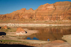
 Evening reflections in the San Juan ArmLast time we were here, it was 105 degrees, and I remember being so hot that I spent the entire afternoon on our float huddled under the bow of the boat in the shade - sort of like a precog in "Minority Report."
Herb, who loves the desert heat, went off by himself for a hike up the ridge. I had to control myself from laughing when he returned holding one of the soles of his chaco sandals that had literally detached when the adhesive holding them on melted.
 Lolo waking up in a sea of reflectionsThis time it was a relatively comfortable 90 degrees, so around 6:00 pm we clambered up to the top of the ridge above our anchorage where we could look out at the San Juan Arm on one side and the main Colorado River channel on the other. Our boat looked so cute down below.
That night when the sun got low the sandstone cliffs surrounding us turned an incredible orange-red hue. This would be a hard camping spot to beat.
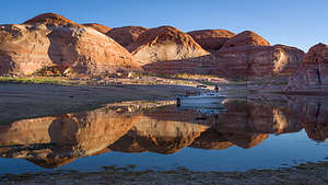
The next morning when I awoke, Herb was already gone, off to take photos in the morning light. When I finally extracted myself from the cuddy cabin, I found myself and our boat in a sea of reflections. Sure enough, there was Herb atop the ridge above our campsite, looking down on me with his camera.
- ‹ previous
- 4 of 9
- next ›
Lake Powell - San Juan Arm location map in "high definition"
Javascript is required to view this map.
