- Home
- About
- Map
- Trips
- Bringing Boat West
- Migration West
- Solo Motorcycle Ride
- Final Family XC Trip
- Colorado Rockies
- Graduates' XC Trip
- Yosemite & Nevada
- Colorado & Utah
- Best of Utah
- Southern Loop
- Pacific Northwest
- Northern Loop
- Los Angeles to NYC
- East Coast Trips
- Martha's Vineyard
- 1 Week in Quebec
- Southeast Coast
- NH Backpacking
- Martha's Vineyard
- Canadian Maritimes
- Ocracoke Island
- Edisto Island
- First Landing '02
- Hunting Island '02
- Stowe in Winter
- Hunting Island '01
- Lake Placid
- Chesapeake
- Provincetown
- Hunting Island '00
- Acadia in Winter
- Boston Suburbs
- Niagara Falls
- First Landing '99
- Cape Hatteras
- West Coast Trips
- Burning Man
- Utah Off-Roading
- Maui
- Mojave 4WD Course
- Colorado River Rafting
- Bishop & Death Valley
- Kauai
- Yosemite Fall
- Utah Off-Road
- Lost Coast
- Yosemite Valley
- Arizona and New Mexico
- Pescadero & Capitola
- Bishop & Death Valley
- San Diego, Anza Borrego, Joshua Tree
- Carmel
- Death Valley in Fall
- Yosemite in the Fall
- Pacific Northwest
- Utah Off-Roading
- Southern CA Deserts
- Yosemite & Covid
- Lake Powell Covid
- Eastern Sierra & Covid
- Bishop & Death Valley
- Central & SE Oregon
- Mojave Road
- Eastern Sierra
- Trinity Alps
- Tuolumne Meadows
- Lake Powell Boating
- Eastern Sierra
- Yosemite Winter
- Hawaii
- 4WD Eastern Sierra
- 4WD Death Valley +
- Southern CA Deserts
- Christmas in Tahoe
- Yosemite & Pinnacles
- Totality
- Yosemite & Sierra
- Yosemite Christmas
- Yosemite, San Diego
- Yosemite & North CA
- Seattle to Sierra
- Southwest Deserts
- Yosemite & Sierra
- Pacific Northwest
- Yosemite & South CA
- Pacific Northwest
- Northern California
- Southern Alaska
- Vancouver Island
- International Trips
- Index
- Tips
- Books
- Photos/Videos
- Search
- Contact
The Narrows and Papoose Flat 4WD Road, CA
Wednesday, October 2, 2019 - 9:00am by Lolo
54 miles and 4 hours from our last stop
Travelogue
 Along the Papoose Flat 4WD RoadAfter leaving Bishop, we headed south on Highway 395 towards Big Pine, where we made a turnoff onto 168 and eventually the Death Valley/Saline Valley Road to get to the start of the Narrows and Papoose Flat 4WD road. It was rated as easy, but we are always somewhat suspect as conditions frequently change.
The first part of the drive took us up through a long, narrow canyon to the Narrows, a high-walled gap in the dark laminated rock. The ride wasn’t too bad, but I wouldn’t exactly call it Easy. Also, we had a little difficulty navigating because the Forest Road names in our 4WD guide didn’t match the ones on the signposts along the way. Fortunately, Herb found a forest road map that he had picked up at the Mono Lake Visitor Center that did have the correct road names.
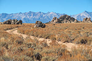
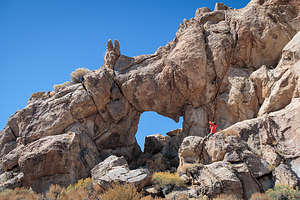
 Along the Papoose Flat 4WD RoadThe highlight of the ride was arriving at Papoose Flat, a unique and otherworldly landscape with granite spires somewhat randomly strewn throughout the desert scrub. One of the granite outcrops even had a large arch, which I thought looked like a map of the U.S. with Florida on the wrong side. You could see the Sierra Nevada mountains through the arch.
The Flat, which lies at the crest of the Inyo Mountains which separate Saline Valley from the Owens Valley was once a food gathering place for the Paiute Indians, who spent the summer and fall in the Inyo Mountains gathering pinyon nuts and killing game for winter.
After leaving the Flat, we descended through a series of switchbacks back to where we started. Some sections were so rocky that we had to get out and construct, or repair, existing rock ramps to smooth things out a bit.
Really interesting ride, but if this was classified as Easy, I’m not sure how anxious I am to get on a Moderate.
- ‹ previous
- 2 of 5
- next ›
The Narrows and Papoose Flat 4WD Road location map in "high definition"
Javascript is required to view this map.

I've done trails in this area many times....camped out in Papoose Flat more than once....beautiful country, and you rarely see anyone else. Tony Huegel's guidebook rates this as easy, but others put it more as moderate. There isn't anything really challenging, per se--people in Wranglers or 4runners would laugh at that--, but I was in my Chevy Tracker, and there are a couple of areas that can get sandy and you have to be careful, and there's some rocky places. Just take it slow and easy, no problem.
I highly recommend a camping trip to Papoose Flat; there are great camp spots up in the hills overlooking it at the far end.....you'll find them. Or just camp anywhere, really. Also....there is a terrific alternate route from the Narrows down to Papoose Flat that is not mentioned in any guide book....and I don't understand why. You take the Narrows Trail from Death Valley road, just past Devil's Gate; the usual start of the trail. When you make the dogleg to the left to enter that slow rocky section that leads to the cabin and Marble Canyon (2 miles of easy but slow crawl), instead take the well-formed trail to the right and follow it. It leads to an awe-inspiring view of the land below; the entire route, basically, down to Papoose Flat.....and in front of you is an extremely steep descent down the mountain. It's really breathtaking. Just put it in 4L and ease down, and you'll have no problem. You follow that road straight for a few miles and you'll come in the back way to PF. Such a cool trail!
Thanks Barry Nitikman for your detailed comment,
Apologies for the late response, but our system was down for a bit.
I would agree that the trail could certainly be considered as moderate.. Especially the last time we went down there after a rain storm.
I've got to check out your alternative route as well. Very impressive if you did this in a Chevy Tracker!
Take care, Herb
Barry, could you map out your comment below? I’ve been to Papoose Flat and want to return and do the Narrows. When did you last do it?
“Also....there is a terrific alternate route from the Narrows down to Papoose Flat that is not mentioned in any guide book....and I don't understand why. You take the Narrows Trail from Death Valley road, just past Devil's Gate; the usual start of the trail. When you make the dogleg to the left to enter that slow rocky section that leads to the cabin and Marble Canyon (2 miles of easy but slow crawl), instead take the well-formed trail to the right and follow it. It leads to an awe-inspiring view of the land below; the entire route, basically, down to Papoose Flat.....and in front of you is an extremely steep descent down the mountain. It's really breathtaking. Just put it in 4L and ease down, and you'll have no problem. You follow that road straight for a few miles and you'll come in the back way to PF.”
H Tom,
Thanks for your comment. Not sure if Barry will respond, but we have done this trip twice now, and enjoyed it each time. I'll try to map out Barry's appoach to see if it might be viable. I'll write you back if I figure it out. Otherwise, google has a lot of other resources regarding access to the Papoose Flats as well.
Take care, Herb