- Home
- About
- Map
- Trips
- Bringing Boat West
- Migration West
- Solo Motorcycle Ride
- Final Family XC Trip
- Colorado Rockies
- Graduates' XC Trip
- Yosemite & Nevada
- Colorado & Utah
- Best of Utah
- Southern Loop
- Pacific Northwest
- Northern Loop
- Los Angeles to NYC
- East Coast Trips
- Martha's Vineyard
- 1 Week in Quebec
- Southeast Coast
- NH Backpacking
- Martha's Vineyard
- Canadian Maritimes
- Ocracoke Island
- Edisto Island
- First Landing '02
- Hunting Island '02
- Stowe in Winter
- Hunting Island '01
- Lake Placid
- Chesapeake
- Provincetown
- Hunting Island '00
- Acadia in Winter
- Boston Suburbs
- Niagara Falls
- First Landing '99
- Cape Hatteras
- West Coast Trips
- Burning Man
- Utah Off-Roading
- Maui
- Mojave 4WD Course
- Colorado River Rafting
- Bishop & Death Valley
- Kauai
- Yosemite Fall
- Utah Off-Road
- Lost Coast
- Yosemite Valley
- Arizona and New Mexico
- Pescadero & Capitola
- Bishop & Death Valley
- San Diego, Anza Borrego, Joshua Tree
- Carmel
- Death Valley in Fall
- Yosemite in the Fall
- Pacific Northwest
- Utah Off-Roading
- Southern CA Deserts
- Yosemite & Covid
- Lake Powell Covid
- Eastern Sierra & Covid
- Bishop & Death Valley
- Central & SE Oregon
- Mojave Road
- Eastern Sierra
- Trinity Alps
- Tuolumne Meadows
- Lake Powell Boating
- Eastern Sierra
- Yosemite Winter
- Hawaii
- 4WD Eastern Sierra
- 4WD Death Valley +
- Southern CA Deserts
- Christmas in Tahoe
- Yosemite & Pinnacles
- Totality
- Yosemite & Sierra
- Yosemite Christmas
- Yosemite, San Diego
- Yosemite & North CA
- Seattle to Sierra
- Southwest Deserts
- Yosemite & Sierra
- Pacific Northwest
- Yosemite & South CA
- Pacific Northwest
- Northern California
- Southern Alaska
- Vancouver Island
- International Trips
- Index
- Tips
- Books
- Photos/Videos
- Search
- Contact
White Rim Trail (Canyonlands National Park), UT
Thursday, May 13, 2021 - 10:30am by Lolo
100 miles and 13 hours from our last stop - 2 night stay
Travelogue
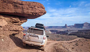 Driving along the White Rim TrailDriving the White Rim Trail has been on Herb’s bucket list since he first gazed down on its switchbacks from the canyon rim of Dead Horse Point State Park back in 2005. It’s supposed to be a phenomenal adventure - 100 miles circling around the Island in the Sky mesa, along cliff edges and past canyons carved out by the Colorado and Green Rivers.
Besides having a high clearance 4WD and some off-roading experience, you also have to have a permit from Canyonlands National Park. If you plan to do it over multiple days, you need to have an overnight backcountry permit. These can be obtained on Recreation.gov.
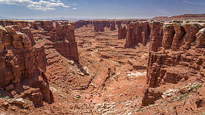 Monument Basin and the "white caps" of the White Rim TrailNormally, planning a trip along the White Rim Trail has to be done months in advance, but I lucked out finding a cancellation, first for one night at Gooseberry (30 miles in), and then later a second cancellation for Murphy Camp about 20 miles further. We were definitely happier about having 3 days to do the drive than 2. You just have to be pretty persistent about revisiting the Recreation.gov each day and seeing if anything has become available.
The direction you drive the trail in is really dependent on your campground reservations. We wanted to drive it clockwise, so we were very happy that we were able to reserve campgrounds that accommodated that.
It doesn’t get too crowded along the trail, because there are only twenty campsites - each of which allows 3 vehicles and 15 people - for a max of 60 vehicles and 300 people. However, that is if each campsite is at full capacity. We, for example, had a campsite, and we were only 1 vehicle with 2 people. Let’s just say that you feel pretty out there and alone.
Day 1 - Shafer Trail Switchbacks, Side Trip to Lathrop Canyon, and Gooseberry A Campground
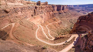 Shafer Trail SwitchbacksThe first part of the journey was a bit of a repeat for us, as we had already driven down the switchbacks a few days ago to get to Potash Road. Zigzagging down the dramatic switchbacks 1,500 feet to the junction of the White Rim Trail and Potash Road was still exciting, even the second time around.
However, this time, rather than bearing left onto Potash Road, we went right and began our journey on the White Rim Trail. From this point on, a permit was required - although no one ever checked.
The White Rim Road was originally constructed in the 1950s by the Atomic Energy Commission to gain access to the uranium deposits in the area. However, the mines didn’t produce much uranium and were soon abandoned. Today it is just used for recreational purposes.
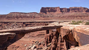 Musselman ArchThe road got its name from the white sandstone which comprises the rim right below the Island in the Sky mesa.
Around 9 miles into the drive we arrived ato Musselman Arch, which is a six feet wide and five feet thick 187 feet long span, 300 feet above the basin below. Walking out on it makes for a very cool photo, so I made Herb do that.
About 8 miles further, we came to the turnoff for the 4-mile (each way) side trip to Lathrop Canyon, and since we only had another 12 miles to get to our campsite for tonight, we decided to take it.
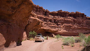 Lathrop CanyonThis was actually the most challenging part of our drive, but it did bring us down to a lovely picnic area on the Colorado River. Fortunately, our timing was perfect for grabbing the only picnic table in the shade. Of course, I had to get my bathing suit on and swim in the river. It was a little tough getting in and out, but there was a nice rock to climb onto a short distance out.
After coming back out of Lathrop Canyon, we passed the large Airport Tower rock formation where there were four campsites.
Along the next portion of the drive, the road got pretty close to the cliff ledges, but fortunately I didn’t know at the time that we were actually driving on a huge overhang with nothing but space below.
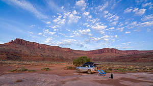 Our Gooseberry campsiteAbout 30 miles from the start of the Shafer Trail Switchbacks (38 if you count the side trip to Lathrop Canyon), we arrived at our campsite at Gooseberry A. Since the campsites are meant to accommodate up to 3 vehicles and 15 people, they are very spacious and private. We even had a nice shade tree to park our chairs under.
Later that afternoon, two motorcycles stopped by, coming from the opposite direction we were doing the Rim in. and asked if they could buy some gas from us. Apparently, at some point during their drive, they realized they wouldn’t make the full loop and turned around. Unfortunately, we don’t carry an extra external gas can and syphoning gas out of our truck doesn’t work. So, they continued on, hopefully finding a Jeep with some external gas. Enough gas and water is something you really have to plan on before embarking on this drive.
Otherwise, the evening passed peacefully. No more cars went by and we felt like we owned the place.
Day 2 - Hike to Island in the Sky, Monument Basin, side trip to White Crack Camp, Ascending Murphy Hogback, and Murphy B Campground
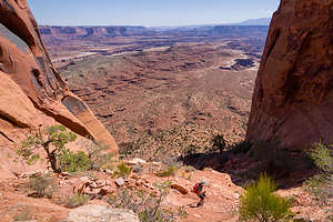 The hike down from Island in the SkyThe next morning, before leaving, we decided to hike the Gooseberry Trail, which started near our campsite and climbed over 1,500 feet up to an overlook at Island in the Sky. In retrospect, I’m not sure why we put so much effort into getting to a spot that 2WD cars drive to, but I guess it’s about the journey.
The first mile and a half of the hike was pretty flat as it followed a wash through Gooseberry Canyon. After that, for the next mile or so it began to climb quite steeply, requiring some rock scrambling and skirting a bit closer to steep drop offs than I like.
We were pretty exhausted by the time we got back to our campsite. Good thing we had less than 20 miles to drive today.
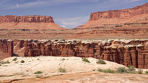 Monument BasinJust after Gooseberry we came to a very cool area called Monument Basin, where there were dozens of spires of red sandstone, capped with more resistant to erosion white tops. These white tops are the “white rim” of the White Rim Trail.
These formations are usually photographed from high above from the Grand View and White Rim Overlooks, but it was much more fun to wander near them more intimately.
After Monument Basin, we took the 1.4 mile spur road to the White Crack Camp, where there is just a single campsite. I would love to have gotten this campsite. Besides having it all to yourself, there is a spectacular view in every direction. - views of the Needles District to the south, the Maze District to the west, and Junction Butte and Grand View Point in the Island in the Sky to the north. It was absolutely lovely, so we stopped here for a picnic lunch.
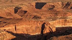 David and Goliath battle on the sandstone cliffsContinuing along our drive, the next challenge was Murphy Hogback, a steep, rocky climb, one where 4WD and high clearance is definitely required. Our campsite at Murphy B was at the top of the climb.
As with Gooseberry, it was a huge site from which we could wander around. The nearest campsite was quite a distance away on the other side of the road. It was filled with a group of mountain bikers and their support vehicles. I forgot to mention that there are probably even more mountain bikers riding the rim than vehicles. It’s quite an epic adventure that most riders do in 3 to 5 days. The record, however, is under 6 hours. I can’t even imagine how that is possible.
During the Golden Hour, we took a walk out to the rim where we could look down on the road we had climbed earlier. I also had a lot of fun photographing the shadows on the canyon walls across the way. One looked a bit like the grim reaper, but I settled into the image of David about to slay Goliath.
Then it was dinner and another lovely sunset.
Day 3- Descending Murphy Hogback, Black Crack, Holeman Slot, Hardscrabble Hill, Mineral Bottom Switchbacks, and back to civilization
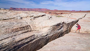 Lolo trying not to fall in ""Black Crack"The next morning we descended the back side of Murphy Hogback. Now when we looked down the canyons at the river below, we were looking at the Green River.
About 7.5 miles from Murphy Camp, we parked in a pullout and walked south about 0.1 mile to the edge of “The Black Crack,” a 3-foot-wide fissure in the sandstone that went down at least 65 feet. It was definitely wide enough to swallow a human being, so we made sure to keep our distance.
Next stop, after another 5 miles of driving, was the Holeman Slot Canyon, formed by a stream cutting into the White Rim sandstone. We went to its entrance and looked down at the smooth slopey sandstone that twisted like a corkscrew through narrow passageways. I don’t know what I was thinking when I got on my butt and slid down this smooth sandstone about 8 feet right into a puddle. I was like a cat that climbs up a tree and can’t get down, but in reverse. Fortunately, Herb followed me down and found an easier way out, or else I would still be in there.
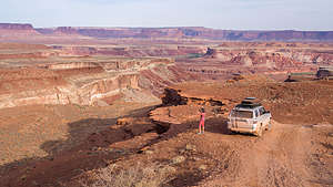 Driving along the White Rim TrailTen miles more and we were at Hardscrabble Hill, which was much more challenging than Murphy’s Hogback in that besides being 5 miles of extremely rocky ups and downs, it is so narrow that there are no turnouts for vehicles to pass each other - meaning that if you meet another vehicle, someone is going to have to do some hairy driving in reverse.
At the top of the hill, I got out to film Herb driving over the lip of the ledges and down the steep, narrow trail. I even captured the sound of the bottom of our truck scraping over one of those ledges.
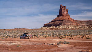 Almost doneThe rest of the drive followed the Green River closely. There were several campgrounds and picnic areas along the river, but I know from past experience that it can get really buggy near the river.
After about 30 miles from Murphy Camp we came to the Canyonlands Park boundary and began our climb up the Mineral Bottom switchbacks. Then the road got easier and after 15 miles we were back on the asphalt of Highway 313.
We had done it!
Our time in Moab was complete, so we headed north to Green River, where we stopped for lunch at Ray’s Tavern, before continuing onto our next destination - Horseshoe Canyon and the Great Gallery (see next stop).
- ‹ previous
- 3 of 8
- next ›
White Rim Trail (Canyonlands National Park) location map in "high definition"
Javascript is required to view this map.

Thanks for the great information and pictures! I'm headed to the White Rim in a few weeks and have a reservation for Murphy B. C
Thanks Caroline, Apologies for the late response but hope you had a great time. It is a great place!