- Home
- About
- Map
- Trips
- Bringing Boat West
- Migration West
- Solo Motorcycle Ride
- Final Family XC Trip
- Colorado Rockies
- Graduates' XC Trip
- Yosemite & Nevada
- Colorado & Utah
- Best of Utah
- Southern Loop
- Pacific Northwest
- Northern Loop
- Los Angeles to NYC
- East Coast Trips
- Martha's Vineyard
- 1 Week in Quebec
- Southeast Coast
- NH Backpacking
- Martha's Vineyard
- Canadian Maritimes
- Ocracoke Island
- Edisto Island
- First Landing '02
- Hunting Island '02
- Stowe in Winter
- Hunting Island '01
- Lake Placid
- Chesapeake
- Provincetown
- Hunting Island '00
- Acadia in Winter
- Boston Suburbs
- Niagara Falls
- First Landing '99
- Cape Hatteras
- West Coast Trips
- Burning Man
- Utah Off-Roading
- Maui
- Mojave 4WD Course
- Colorado River Rafting
- Bishop & Death Valley
- Kauai
- Yosemite Fall
- Utah Off-Road
- Lost Coast
- Yosemite Valley
- Arizona and New Mexico
- Pescadero & Capitola
- Bishop & Death Valley
- San Diego, Anza Borrego, Joshua Tree
- Carmel
- Death Valley in Fall
- Yosemite in the Fall
- Pacific Northwest
- Utah Off-Roading
- Southern CA Deserts
- Yosemite & Covid
- Lake Powell Covid
- Eastern Sierra & Covid
- Bishop & Death Valley
- Central & SE Oregon
- Mojave Road
- Eastern Sierra
- Trinity Alps
- Tuolumne Meadows
- Lake Powell Boating
- Eastern Sierra
- Yosemite Winter
- Hawaii
- 4WD Eastern Sierra
- 4WD Death Valley +
- Southern CA Deserts
- Christmas in Tahoe
- Yosemite & Pinnacles
- Totality
- Yosemite & Sierra
- Yosemite Christmas
- Yosemite, San Diego
- Yosemite & North CA
- Seattle to Sierra
- Southwest Deserts
- Yosemite & Sierra
- Pacific Northwest
- Yosemite & South CA
- Pacific Northwest
- Northern California
- Southern Alaska
- Vancouver Island
- International Trips
- Index
- Tips
- Books
- Photos/Videos
- Search
- Contact
Berchtesgaden National Park, Germany
Monday, May 29, 2017 - 2:00pm by Lolo
25 miles and 0.5 hours from our last stop - 2 night stay
Travelogue
Day 1 - Konigsee Ferry to Salat and St. Bartholomew
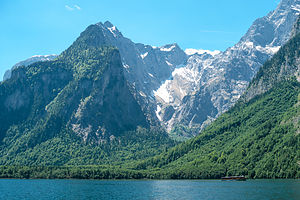 Ferry on KonigseeWe had spent the past few days exploring cities and castles, which had been wonderful, but we were about ready to explore some natural beauty. Berchtesgaden National Park was very high on our list of places we wanted to see, so we left Salzburg a day early to get there before the bad weather that was forecasted moved in. This would be our first opportunity to hike in the Alps, and we were quite excited about it.
Although there are no campgrounds in the national park itself, a small, family-run campground called Campingplatz Grafenlehen is right nearby. From there, it’s just a ¾-mile walk on a lovely path alongside a river to the northern end of Konigsee Lake and boat docks from which the lake ferry departs. Perfect!
Fortunately, the campground had room for us and by noon, we were nicely tucked into a site with very pretty views of the mountains. Like the other campgrounds we had been to so far, this one had a beer garden and restaurant on site - a wonderful amenity that you almost never find in campgrounds in the States.
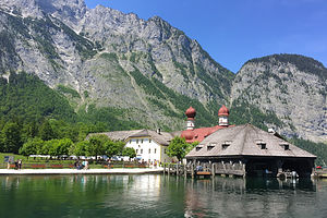 St. BartholomewSince the forecast was a little questionable for tomorrow, we wanted to make the most of today, so we packed lunch and set off immediately on the path to the Konigsee.
The lake is stunning. No wonder Bavarian and Austrian royalty spent centuries recreating here. It was also one of Adolf Hitler and Eva Braun’s favorite vacation spots. They used to go boating on its waters and sunbathe on its shores - not a very pleasant image.
The lake is about 5 miles long, crystal clear, and narrow, like a fjord. It is surrounded on all sides by steep, vertical walls, so there is no path around the lake. The only way to get anwhere is by ferry.
The ferry makes only two scheduled stops: St. Bartholomew and Salat. It also stops on request at a backpacker’s dock on the eastern side of the lake. We purchased two round-trip tickets (17.80 euro each) that would allow us to get off at both stops. The whole round-trip takes about 2 hours.
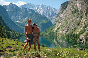 Salat to Obersee to Rothbachfalls HikeThe ferry was a beautiful wooden boat that was electrically powered and extremely quiet. About 20 minutes into our trip, the captain shut off the engine and a crewman reached under the seat next to us and extracted a musical instrument case. He then rather dramatically pulled out a trumpet and began to play a duet with the echo that reverberated off the surrounding rock walls. Actually, it was more of a quintet the way the sound kept bouncing around.
About half way up the lake, the boat stopped to let people off at St. Bartholomew, where there is a beautiful, baroque, onion-domed chapel that was built in the late 1600s. We decided to stay on the boat for now and go to Salat on the southernmost end of the lake first. Then we could stop here on the way back.
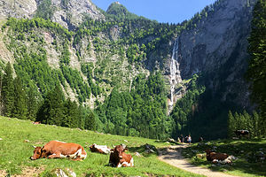 Friendly German cows lounging near the RothbachfallFrom the boat dock in Salat it was only a quarter mile walk to the Obersee, a pristine alpine lake, much smaller than the Konigsee. At the far end of the Obersee, there is a solitary alpine hut called the Fischunkelalm, which serves refreshments to hikers. From the Fischunkelalm, two paths lead up through an alpine meadow towards Rothbachfall, the highest waterfall in Germany, which we could now see in the distance.
It was fun hiking up through the meadow, weaving in and out of a dozen or so very mellow cows. They were so docile you could practically pet them. To my delight, cows in the Alps really do wear huge cowbells, the sound of which I found very quaint, but must drive the cows themselves crazy after awhile. I guess someone must live up here, because someone had to milk them.
We continued along a bit further, but didn’t go all the way to the base of the falls, as the view from a bit further away was good enough. Plus, we wanted to get back to the ferry to have enough time to spend at St. Bartholomew, from which the last ferry of the day departed at 6:00 pm.
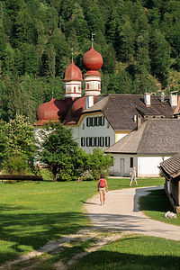 St. Bartholomew ChapelThe entire hike from the Salat boat dock to and from our vantage point of Rothbachfall was only about 2 miles, but what a satisfying two miles it was - pristine alpine lake and meadow, a cowbell symphony by a troupe of friendly cows, beautiful waterfall, and mountain views. Our first hike in the Alps!! They say you never forget your first, and I think in this case, it will be true.
We got to St. Bartholomew with about an hour to spare. This small onion-domed pilgrimage church, with Watzmann mountain looming behind it, is one of the most visited and photographed places in Berchtesgaden. It is easy to see why.
Originally built in the 12th century in the Gothic style, it was remodeled in the 16th century into its current baroque appearance. It has two onion domes, one octagonal and one round, on a red domed roof. After Berchtesgaden joined Bavaria in 1810, the church became a hunting lodge for the Bavarian Kings.
There is a restaurant and beer garden outside the church. During the summer, they serve fresh fish right from the lake. No other fishing is allowed on the lake.
This was one of the few places along the lake that you could stroll along the shoreline, so we did just that before returning to the ferry back home.
What a wonderful day it had been. Even if it did rain all day tomorrow, I think Berchtesgaden would live on as one of our favorite stops.
Day 2 - Hike to summit of Mt. Jenner
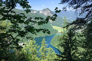 Glimpses of the Konigsee at the start of our Jenner hikeWe awoke to a very pleasant surprise - no rain. In fact, the sun was shining. Herb suggested that we take the Jennerbahn (cable car) to the top of Mt. Jenner and then hike the 6 miles back down. The views from the summit down to the Konigsee were supposed to be spectacular. It sounded like a great plan.
According to Google Maps the Visitor Center to buy Jennerbahn tickets was near where we bought the ferry tickets yesterday, so we set off once again along the river path into Konigsee village. I remember thinking to myself that it was funny that we hadn’t noticed the cable cars passing overhead on our boat tour yesterday, which should have been a forewarning of what was to come.
The girl at the Visitor Center didn’t speak English very well, but I soon got the gist - the Jennerbahn was under construction and wouldn’t reopen until 2018. So that’s why we didn’t see any cable cars. After exchanging some concerned looks, Herb and I decided that we would hike instead, at least up part of it. We asked the girl for a trail map.
While reviewing the map with her, I noticed that there were several huts along the way, which from my brief exposure to the German culture, I suspected meant beer garden. I asked her about them, but did not really understand her answer. I was only able to decipher the word “Schnapps.” In retrospect, I think I can now approximate a translation of what she was trying to say - “all the beer gardens are closed as well, so I hope you’ve brought along your own schnapps.”
 Herb playing with the cows on Konigsbach AlmArmed with a map and good attitudes, we walked passed the valley cable car(less) station and up the steep Jennerbahnstrasse through a lovely residential area with picture perfect Bavarian-style houses.
After turning onto the Richard-Voss-Strasse, we came upon our first trail marker, a series of yellow arrow-shaped signs atop a pole, indicating destinations and times (rather than distances) to get to them - a much more meaningful measure in steep terrain. Unbeknownst to us at the time, this system of marking trails was used at every trail junction throughout Germany, Austria, Switzerland, and Italy. Herb said he read somewhere that in Switzerland they have the local senior citizens walk the trails and establish the times. If so, I am impressed, because they were pretty dead on with our hiking times -- but then again, we are not too far from being senior citizens ourselves.
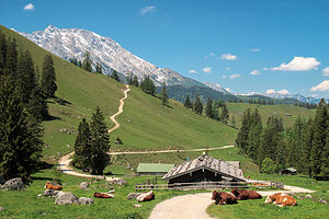 Konigsbach Alm on hike up to Jenner summitWe made a right onto the Hochbahnweg towards Konigsbach Alm (alpine meadow), two hours away, thinking that might be a good destination for the day. The trail led us up a forested slope with occasional views of the Konigsee, somewhat obscured by the trees. Hopefully, they would get better when we got more out in the open in the meadow.
Pretty much on time (2 hours), we arrived at the Konigsbach Alm, where there was a restaurant/beer garden that was quite obviously closed. I guess without the Jennerbahn running, there weren’t enough customers to make it worth opening. We sat on a rock and ate our peanut butter sandwiches and water. I wish I had brought schnapps.
Herb had been hoping that Konigsbach Alm would be a lovely meadow to just spend time relaxing in and taking in the view, but although very pretty, it really wasn’t very conducive to that. It was more of a pasture for cows to hang out in.
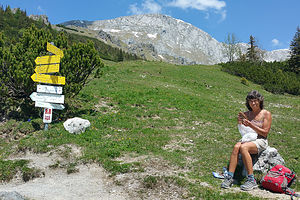 Coping with Peanut Butter when the Beer Gardens are closedNow what? The trail marker showed that it was another two hours to Jenner summit. We didn’t want to just turn around and do an out and back, so we decided to forge on.
This part of the hike was much more open, with long vistas as far as the eye could see. It seemed like it went on forever. Finally, after 6 miles and a 4,800-foot elevation gain, over a 3 hour period, we arrived at the upper station of the Jennerbahn.
It was eerily deserted. I am sure this place is bustling in winter time and in summers as well when the cable car can transport people to the top. For now, it was all ours, and we had earned it.
From the lodge, which was also under reconstruction, we hiked another 10 minutes up to the viewpoint on Mt. Jenner’s summit (1874 meters), where a large cross stood atop a rocky pile, marking its highest point. Of course, we had to scramble up to it. We didn’t come this far to not get to the official summit.
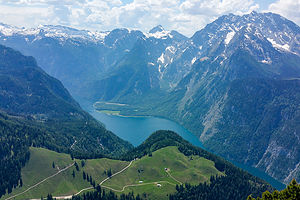 View from Jenner summitThe views were worth every step of the way. The crystal blue waters of the Konigsee lay below us, surrounded by over a 100 German and Austrian snow-covered mountain peaks. It was utterly breathtaking. We could just make out the tiny ferries scooting silently across the water below us.
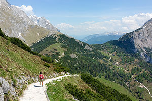
Rather than hike down the same way we came up, we followed the trail signs to the Jennerbahn Mittelstation. While the hike was nice at first, the trail eventually brought us onto a ski resort road that was undergoing construction. It was horrible - no pristine forests or mountain vistas; just noisy trucks kicking up clouds of dirt, and ruts to twist your ankle in. If we had come up this way first, we never would have continued on to the summit.
Ominous storm clouds were starting to build - perhaps that anticipated bad weather was finally on its way. Despite being quite tired, we picked up the pace to try to beat out the storm.
Hiking down always sounds better on paper, but I often find it harder on my legs and feet. We limped back into the campground, just as the skies opened up and the rain began to fall.
All in all we had hiked 13 ½ miles that day, with almost a mile of elevation gain. Most of it had been truly spectacular.
Description
 Start of the descent from Jenner summitBerchtesgaden National Park, in southeastern Germany near the Austrian border, is one of the oldest protected areas in the Alps. The park, which was established in 1978, encompasses 218 square kilometers of lakes, mountains, forests of dwarf pines, and alpine meadows.
The gem of the park is the beautiful Konigssee, a 5-mile long, crystal clear, fjordlike lake,
surrounded on all sides by steep, vertical walls, including the Watzmann, Germany’s second highest mountain.
An electrically driven boat ferry is the only way to access points around the lake. The ferry makes only two scheduled stops:
- St. Bartholomew, where there is a beautiful baroque, onion domed chapel, as well as a restaurant and beer garden
- Salat, on the southern shore where there are hikes to the Obersee and Rothbachfalls, the highest waterfall in Germany.
The Jennerbahn (cable car) scoots visitors to the summit of Mt. Jenner for fantastic views of the Konigsee, surrounded by over a 100 German and Austrian snow-covered mountain peaks, including Mount Watzmann.
Note:
When we were there in June 2017, the Jennerbahn was closed with plans to reopen in 2018. We hiked to the top instead
- ‹ previous
- 6 of 17
- next ›
Berchtesgaden National Park location map in "high definition"
Javascript is required to view this map.
