- Home
- About
- Map
- Trips
- Bringing Boat West
- Migration West
- Solo Motorcycle Ride
- Final Family XC Trip
- Colorado Rockies
- Graduates' XC Trip
- Yosemite & Nevada
- Colorado & Utah
- Best of Utah
- Southern Loop
- Pacific Northwest
- Northern Loop
- Los Angeles to NYC
- East Coast Trips
- Martha's Vineyard
- 1 Week in Quebec
- Southeast Coast
- NH Backpacking
- Martha's Vineyard
- Canadian Maritimes
- Ocracoke Island
- Edisto Island
- First Landing '02
- Hunting Island '02
- Stowe in Winter
- Hunting Island '01
- Lake Placid
- Chesapeake
- Provincetown
- Hunting Island '00
- Acadia in Winter
- Boston Suburbs
- Niagara Falls
- First Landing '99
- Cape Hatteras
- West Coast Trips
- Burning Man
- Utah Off-Roading
- Maui
- Mojave 4WD Course
- Colorado River Rafting
- Bishop & Death Valley
- Kauai
- Yosemite Fall
- Utah Off-Road
- Lost Coast
- Yosemite Valley
- Arizona and New Mexico
- Pescadero & Capitola
- Bishop & Death Valley
- San Diego, Anza Borrego, Joshua Tree
- Carmel
- Death Valley in Fall
- Yosemite in the Fall
- Pacific Northwest
- Utah Off-Roading
- Southern CA Deserts
- Yosemite & Covid
- Lake Powell Covid
- Eastern Sierra & Covid
- Bishop & Death Valley
- Central & SE Oregon
- Mojave Road
- Eastern Sierra
- Trinity Alps
- Tuolumne Meadows
- Lake Powell Boating
- Eastern Sierra
- Yosemite Winter
- Hawaii
- 4WD Eastern Sierra
- 4WD Death Valley +
- Southern CA Deserts
- Christmas in Tahoe
- Yosemite & Pinnacles
- Totality
- Yosemite & Sierra
- Yosemite Christmas
- Yosemite, San Diego
- Yosemite & North CA
- Seattle to Sierra
- Southwest Deserts
- Yosemite & Sierra
- Pacific Northwest
- Yosemite & South CA
- Pacific Northwest
- Northern California
- Southern Alaska
- Vancouver Island
- International Trips
- Index
- Tips
- Books
- Photos/Videos
- Search
- Contact
Badlands National Park, SD
Monday, July 31, 2000 - 10:00am by Lolo
32 miles and 1 hour from our last stop - 1 night stay
Travelogue
After a very entertaining stop at Wall Drug, we headed for Badlands National Park. Badlands is an easy National Park to visit because it has a 32-mile scenic drive that runs from east to west across the park past several scenic overlooks and trailheads for hikes. Since we were heading home, we entered the park at the Pinnacles Entrance in the western portion of the park.
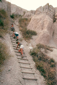 Notch Trail Shaky Ladder ClimbThis was the first time since we left Michigan about 2½ weeks ago that we didn't have a reservation for the night. Wow, free spirits at last. When we got our first look at the South Dakota badlands from the Pinnacles Overlook, we knew that we wanted to spend the night here. The view was incredible--sharp, jagged ridges and multicolored buttes rising out of the prairie.
Now began the debate as to where to stay. It was over 100 degrees, so my vote was for the Badlands KOA right outside the park where there was a pool and we could run our air conditioning. After our horrible commercial campground experience at Mt. Rushmore, Herb wanted to stay at the Cedar Pass Campground inside the park. He assured me, and I must admit he was correct, that this was the desert and temperatures dropped significantly at night so we wouldn't need air conditioning. He won. The campground was lovely--great views of the Badlands and a nice shade covering over the picnic table.
After lunching and enjoying the views at the campsite, we headed to the Visitor Center to get some information on hikes so that we could experience the badlands more intimately. I had chosen the 1.5 mile Notch Trail, but a very acrophobic woman ranger nearly talked us out of it when she described how you had to climb a steep, shaky ladder and then walk along a narrow cliff edge that dropped sharply off into a steep gully. Although this information made me think twice about the hike, it actually intrigued the kids even more. If they were enthused about a hike, I'm there.
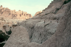 Badlands Notch Trail hikeI'm really glad we didn't listen to her--it wasn't nearly as bad as she made it out to be. There was in fact a steep, shaky ladder, but it was no big deal and although the cliff edge made my palms sweat a little more, it was also very doable. What the kids liked best was that they were able to climb and scamper on the rock formations as they went along--not like other parks were you always had to stay on a trail and just admire the rocks. At the end of the hike we were rewarded with a spectacular view of the badlands and prairie below.
That evening back at the campground, we watched a beautiful sunset from our picnic table. After dinner, the kids and I decided to go to the campground amphitheater for the Ranger Program. I really like to take advantage of these programs--they're always very informative and well done, especially if you have an enthusiastic ranger, which we did. Herb was too content sitting with his Gin and Tonic, gloating about his campground selection, to accompany us so the kids and I went alone, taking along a flashlight to find our way back when it got dark later.
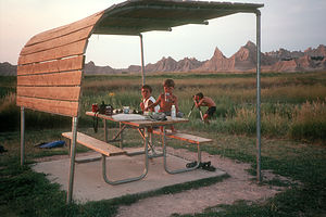 Sunset at the campThe talk was interesting because it focused on life on the Badland's prairie, and made you realize that there was a lot more to this park than just the interesting rock formations. Having very much enjoyed the talk, the kids and I exited the amphitheater into the campground, which now looked totally different in the pitch-black conditions. Despite my ability to navigate our RV across an entire continent, when not equipped with a GPS and laptop I am what Herb politely describes as navigationally impaired. The kids and I proceeded to wander aimlessly up and down each lane in the campground looking for our motor home. Being very aware of my limitations, Herb must have started to get concerned when we didn't return right away. He said he looked out the RV and in the distance he saw 3 little heads wandering aimlessly back and forth across the campground shining our little beacon of light ahead of us. After a good laugh, he came and rescued us.
Before leaving the Badlands for good the next morning we stopped along the scenic drive to hike the Door Trail. This relatively short, but fairly strenuous hike took us through a break in The Wall called "The Door" and into a very rugged, eroded section of the badland that looks more like the surface of the moon than any place on Earth.
Like Theodore Roosevelt National Park, Badlands was an unexpected highlight for us. The rugged beauty and remoteness of the badlands was something that all four of us had come to love.
Description
Badlands National Park encompasses more than 381 square miles of the eroded buttes, pinnacles, jagged ridges, and prairies that make up the badlands of South Dakota. The rock formations rise from the plains like a city skyline, creating a 100-mile-long natural barrier referred to as The Wall. In fact, early French-Canadian fur trappers named this area les mauvaises terres a traverser or "bad lands to travel across."
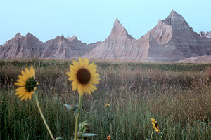 Badlands sunsetThis barren yet beautiful landscape began forming more than 70 million years ago when the climate here was much warmer and wetter, and the Great Plains were covered by a shallow, inland sea. Over time, the land was pushed up, the sea receded, and the black mud of the sea floor hardened into shale, preserving the fossils of animals now long extinct. The area became a flood plain, receiving sediment deposits every time the rivers overflowed. Some of the sediment was mixed with volcanic ash, which together formed clay stone, the main material that makes up the Badlands buttes. Around half a million years ago, wind and water began cutting through the softer layers of sedimentary rock, carving buttes, gullies, and sawtoothed ridges out of the flat flood plains.
The result is the eerie moonscape you see today--jagged sawtoothed ridges and oddly-shaped spires, with their exposed ancient rock layers painted in shades of sand, gold, pink, and red. The erosion has also exposed the rich fossil beds from the ancient sea floor, drawing scientists from around the world to study the preserved remains of extinct animals, such as miniature camels and saber-toothed cats.
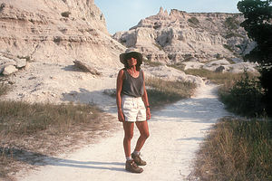 Lolo of the BadlandsThis erosion still continues today, with wind and water washing away an average of one inch of sediment from the buttes each year. At this rate, they will be completely gone in another half a million years.
An excellent way to see the beauty of the Badlands is to drive along the 32-mile Badlands Loop Road that crosses the North Unit of the park, stopping at the numerous scenic overlooks along the way. However, to truly experience the badlands, you have to get out of your car and take one of the hikes into The Wall. There are three excellent hikes that start from the Windows Overlook parking lot.
The ¾ mile, fairly strenuous Door Trail passes through a break in The Wall called "The Door" into a very rugged, eroded section of the badland that looks more like the surface of the moon than any place on Earth.
The ¼ mile easy Window Trail leads to a spectacular view of a deeply eroded canyon through an opening called "The Window."
The 1½ mile, fairly strenuous Notch Trail is not recommended for those with a fear of heights, as it requires you to climb a steep, shaky ladder and then climb along the side of a steep gully to a break in the wall called "The Notch" where there is a commanding view of the Cliff Shelf area and the White River Valley below.
- ‹ previous
- 20 of 25
- next ›
Badlands National Park location map in "high definition"
Javascript is required to view this map.

It's funny you should say that parts of the Badlands look like the surface of the moon. Some of the asteroid scenes from the movie Armageddon were filmed here. I have lived in South Dakota almost all my life, although in the south-eastern section, and I never get tired of driving and hiking through the park.
I love the badlands.
The KOA is in fact great. But I've never stayed inside the park. Heard my 40 footer would be a tight fit, and the NP's don't like my dog much.
Question though... As I recall, when travelling from west to east, you go into the NP, and drive it's length, and then exit at Wall?a