- Home
- About
- Map
- Trips
- Bringing Boat West
- Migration West
- Solo Motorcycle Ride
- Final Family XC Trip
- Colorado Rockies
- Graduates' XC Trip
- Yosemite & Nevada
- Colorado & Utah
- Best of Utah
- Southern Loop
- Pacific Northwest
- Northern Loop
- Los Angeles to NYC
- East Coast Trips
- Martha's Vineyard
- 1 Week in Quebec
- Southeast Coast
- NH Backpacking
- Martha's Vineyard
- Canadian Maritimes
- Ocracoke Island
- Edisto Island
- First Landing '02
- Hunting Island '02
- Stowe in Winter
- Hunting Island '01
- Lake Placid
- Chesapeake
- Provincetown
- Hunting Island '00
- Acadia in Winter
- Boston Suburbs
- Niagara Falls
- First Landing '99
- Cape Hatteras
- West Coast Trips
- Burning Man
- Utah Off-Roading
- Maui
- Mojave 4WD Course
- Colorado River Rafting
- Bishop & Death Valley
- Kauai
- Yosemite Fall
- Utah Off-Road
- Lost Coast
- Yosemite Valley
- Arizona and New Mexico
- Pescadero & Capitola
- Bishop & Death Valley
- San Diego, Anza Borrego, Joshua Tree
- Carmel
- Death Valley in Fall
- Yosemite in the Fall
- Pacific Northwest
- Utah Off-Roading
- Southern CA Deserts
- Yosemite & Covid
- Lake Powell Covid
- Eastern Sierra & Covid
- Bishop & Death Valley
- Central & SE Oregon
- Mojave Road
- Eastern Sierra
- Trinity Alps
- Tuolumne Meadows
- Lake Powell Boating
- Eastern Sierra
- Yosemite Winter
- Hawaii
- 4WD Eastern Sierra
- 4WD Death Valley +
- Southern CA Deserts
- Christmas in Tahoe
- Yosemite & Pinnacles
- Totality
- Yosemite & Sierra
- Yosemite Christmas
- Yosemite, San Diego
- Yosemite & North CA
- Seattle to Sierra
- Southwest Deserts
- Yosemite & Sierra
- Pacific Northwest
- Yosemite & South CA
- Pacific Northwest
- Northern California
- Southern Alaska
- Vancouver Island
- International Trips
- Index
- Tips
- Books
- Photos/Videos
- Search
- Contact
Mount Rushmore, SD
Sunday, July 30, 2000 - 2:00pm by Lolo
47 miles and 1 hour from our last stop - 1 night stay
Travelogue
Before visiting the very majestic Mount Rushmore, we checked into our very non-majestic campground, Miners RV Park, a campground so bad that it approached humorous. A very cranky octogenarian directed us to our home for the night---a tiny campsite overlooking a dilapidated Laundromat. The sites were so small and so close together that our dump hose was literally 1 foot away from our neighbor's picnic table, which they happened to be sitting at when we pulled in. Although we actually did need to dump, Herb--thinking it would be poor form during their lunch--decided to wait until a more opportune time.
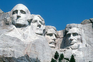
 Mount RushmoreWhen you travel like this, you have to learn to roll with the punches and take the good with the bad and realize that sometimes the bad can produce some pretty good laughs. It's hard to judge a campground just from the Woodall's Guide. I had chosen this campground for 2 very good reasons: it was the closest to Mt. Rushmore and it claimed to have view of it from its hot tub, both of which were true. Besides, the nice thing about a motor home is that if the ambience isn't right, you can just pull down your shades and pretend that you're somewhere else.
We ate lunch as quickly as we could, never leaving the RV, and headed up to Mt. Rushmore, and I mean up. This had to be the steepest road we have ever driven on, even counting the Rockies. Now I know why the woman I spoke to when making the reservations responded the way she did when I asked her if it were possible to bike from the campground to the Monument. She must have thought I was a lunatic. Despite the 14% grade, our faithful little Lazy Daze plowed right up the hill past several RVs pulled over to the side of the road with their hoods up.
We started our visit at the Visitor Center and Museum, where we learned quite a bit about how Gutzon Burglum created this man-made wonder---from his selection of the mountain to carve it on in 1924 through its completion by his son after his death in 1941.
Once outside the museum, we strolled along the Avenue of Flags towards the 60-foot-high faces of George Washington, Thomas Jefferson, Theodore Roosevelt, and Abraham Lincoln set against the South Dakota Black Hills. I had seen Mt. Rushmore in pictures many times, but only in person can you realize its true grandeur and massiveness.
We took a short nature trail to the Borglum's Sculptor's Studio where we saw some of the original tools and the actual plaster model that Borglum used as a basis for carving the mountain. A guide explained to us how Borglum used a pointing system and multiplied every dimension of the model by 12 to arrive at the dimensions of the actual carving. Sounds simple, doesn't it?
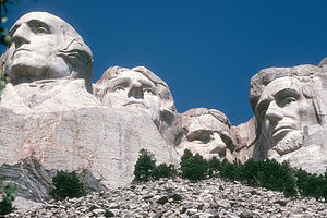
For a close-up view of the actual sculpture, we walked the new ½ mile Presidential Trail which took us up to the talus slope at the base of the Monument. It really is very impressive. Because of its southeasterly orientation, the afternoon lighting wasn't that great, so we decided to save our picture taking for the morning.
I would have to say that my highlight at Mt. Rushmore was the evening lighting ceremony at the amphitheater, which is held every night at 8:00 pm. It started off with a short ranger talk and a film about the 4 presidents and then moved into the dramatic and patriotic part---the flooding of sculpture with lights as we sang the National Anthem. It really was spectacular.
Back at the campground, we went in the hot tub to see if we really had a view of the lit monument and guess what, we actually did. The campground had redeemed itself.
Before heading towards the Badlands the next morning, we drove back up the steep hill to the Monument to photograph it in the morning light. It's amazing what a difference lighting can make.
Description
Mount Rushmore, located in the Black Hills of southwestern South Dakota, is considered to be one of the man-made wonders of the world---as both a work of art and as an engineering marvel.
 Mount RushmoreIt was created by the sculptor Gutzon Borglum, and 300 workers, who worked for more than 14 years carving the 60-foot-tall faces of four American Presidents--George Washington, Thomas Jefferson, Theodore Roosevelt, and Abraham Lincoln--out of the granite of the Black Hills mountains. It was to symbolize the spirit of our nation through four of its most revered leaders.
A short nature trail takes you to the Borglum's Sculptor's Studio, which has on display the original tools and the actual plaster model that Borglum used as a basis for carving the mountain. A 15-minute Studio Talk explains how he used this model's measurements and a pointing system (everything dimension multiplied by 12) to plan the actual carving on the mountain.
The new ½-mile-long Presidential Trail takes you from the main viewing terrace to the talus slope at the base of the sculpture. This trail provides the closest access to the sculpture.
Every evening at 8:00 pm during the summer, there is a ranger program that ends in the dramatic lighting of the memorial. The program consists of a short ranger talk, a film about the 4 presidents, the playing of the National Anthem, and the lighting of the sculpture.
- ‹ previous
- 18 of 25
- next ›
Mount Rushmore location map in "high definition"
Javascript is required to view this map.

I was here a few times and I also agree that the highlight of the visit was the evening lighting ceremony. Awesome. Was here in 1991 when we walked up a path thru the woods to view Mt Rushmore for the first time. Perfect view then..
but now with the new renovations done in the 90's, when walking up from parking lot,this same view is obstucted by a granite overhang entrance which is embedded with the letters Mt Rushmore National Monument. Big MISTAKE here..
Front of entrance to Mt Rushmore should have been left open if ever injustice was done THIS is IT.....
To obstruct the full view when entering........
Unforgivable