- Home
- About
- Map
- Trips
- Bringing Boat West
- Migration West
- Solo Motorcycle Ride
- Final Family XC Trip
- Colorado Rockies
- Graduates' XC Trip
- Yosemite & Nevada
- Colorado & Utah
- Best of Utah
- Southern Loop
- Pacific Northwest
- Northern Loop
- Los Angeles to NYC
- East Coast Trips
- Martha's Vineyard
- 1 Week in Quebec
- Southeast Coast
- NH Backpacking
- Martha's Vineyard
- Canadian Maritimes
- Ocracoke Island
- Edisto Island
- First Landing '02
- Hunting Island '02
- Stowe in Winter
- Hunting Island '01
- Lake Placid
- Chesapeake
- Provincetown
- Hunting Island '00
- Acadia in Winter
- Boston Suburbs
- Niagara Falls
- First Landing '99
- Cape Hatteras
- West Coast Trips
- Burning Man
- Utah Off-Roading
- Maui
- Mojave 4WD Course
- Colorado River Rafting
- Bishop & Death Valley
- Kauai
- Yosemite Fall
- Utah Off-Road
- Lost Coast
- Yosemite Valley
- Arizona and New Mexico
- Pescadero & Capitola
- Bishop & Death Valley
- San Diego, Anza Borrego, Joshua Tree
- Carmel
- Death Valley in Fall
- Yosemite in the Fall
- Pacific Northwest
- Utah Off-Roading
- Southern CA Deserts
- Yosemite & Covid
- Lake Powell Covid
- Eastern Sierra & Covid
- Bishop & Death Valley
- Central & SE Oregon
- Mojave Road
- Eastern Sierra
- Trinity Alps
- Tuolumne Meadows
- Lake Powell Boating
- Eastern Sierra
- Yosemite Winter
- Hawaii
- 4WD Eastern Sierra
- 4WD Death Valley +
- Southern CA Deserts
- Christmas in Tahoe
- Yosemite & Pinnacles
- Totality
- Yosemite & Sierra
- Yosemite Christmas
- Yosemite, San Diego
- Yosemite & North CA
- Seattle to Sierra
- Southwest Deserts
- Yosemite & Sierra
- Pacific Northwest
- Yosemite & South CA
- Pacific Northwest
- Northern California
- Southern Alaska
- Vancouver Island
- International Trips
- Index
- Tips
- Books
- Photos/Videos
- Search
- Contact
Guadalupe Mountains National Park, TX
Thursday, August 1, 2002 - 5:30am by Lolo
35 miles and 0.75 hours from our last stop
Travelogue
Our drive from Carlsbad Caverns dipped back down into Texas and passed through the southeastern corner of Guadalupe Mountain National Park. Unable to just drive by a National Park Visitor Center without stopping, we pulled in to get some information about the park and to see if there was an interesting drive or hike to do for a few hours. We quickly learned that this is not a drive through park and that most of the good stuff was only reached by hiking long distances. In fact, the premier hike in the park is the strenuous 4.2 mile (one way) hike to the summit of Guadalupe Peak, the highest mountain in Texas. There was no way we were going to do that hike today--it was oppressively hot, it would take a good 8 hours, and we just weren't prepared.
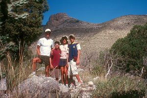
 Family rejecting Lolo's hikeThe ranger suggested we hike the Devil's Hall Trail, which began at the Visitor Center and followed a streambed through Pine Springs Canyon to a natural rock staircase. It was fairly flat and about 4 miles roundtrip. Sounded like what we were looking for. Well, we didn't get too far. Less than a mile into the hike, Tommy kept swatting his neck and complaining about the bugs. The rest of us weren't being bothered by them, but they were swarming around Tommy. Poor Tom. Ever since he was little, he has been like a magnet for bugs. We tried to encourage him to go on, but he wasn't buying it--I don't blame him. We quickly hiked back to the RV, debugged him, and headed back into New Mexico on our way to White Sands National Monument.
Description
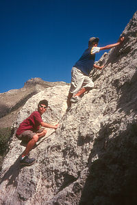
 Kid's climbing Rock!Guadalupe Mountain National Park in west Texas contains the southernmost and highest part of the Guadalupe Mountain range, which appears like a giant wall rising out of the desert. The Guadalupe Mountains are actually a 400-mile-long limestone reef that was formed about 250 million years ago when a tropical ocean covered most of this area. The reef was buried in sediment until forces uplifted the Guadalupes and exposed the limestone reef below. Geologists from all around the world come here to see one of the best examples on Earth of an ancient marine fossil reef.
Guadalupe Mountain National Park is not a highly visited park both because of its remote location as well as the fact that it is really a hiking park, with most of its treasures inaccessible by car. There are over 80 miles of hiking trails, the premier one being the hike to the summit of 8,749-foot high Guadalupe Peak, the highest mountain in Texas.
The park has three sections. The Pine Springs section, in the southeast, has a Visitor Center and campground and is the starting point for many hikes, including the one to Guadalupe Peak. The McKittrick Canyon section of the park, in the northeast,
is a 5-mile long canyon with streams and forests of maples and oaks, with brilliant colors in the fall. Dog Canyon in the north is wilder and more isolated with trails leading into the high country.
Videos
-
Guadalupe Mountains National Park
- ‹ previous
- 8 of 36
- next ›
Guadalupe Mountains National Park location map in "high definition"
Javascript is required to view this map.
