- Home
- About
- Map
- Trips
- Bringing Boat West
- Migration West
- Solo Motorcycle Ride
- Final Family XC Trip
- Colorado Rockies
- Graduates' XC Trip
- Yosemite & Nevada
- Colorado & Utah
- Best of Utah
- Southern Loop
- Pacific Northwest
- Northern Loop
- Los Angeles to NYC
- East Coast Trips
- Martha's Vineyard
- 1 Week in Quebec
- Southeast Coast
- NH Backpacking
- Martha's Vineyard
- Canadian Maritimes
- Ocracoke Island
- Edisto Island
- First Landing '02
- Hunting Island '02
- Stowe in Winter
- Hunting Island '01
- Lake Placid
- Chesapeake
- Provincetown
- Hunting Island '00
- Acadia in Winter
- Boston Suburbs
- Niagara Falls
- First Landing '99
- Cape Hatteras
- West Coast Trips
- Burning Man
- Utah Off-Roading
- Maui
- Mojave 4WD Course
- Colorado River Rafting
- Bishop & Death Valley
- Kauai
- Yosemite Fall
- Utah Off-Road
- Lost Coast
- Yosemite Valley
- Arizona and New Mexico
- Pescadero & Capitola
- Bishop & Death Valley
- San Diego, Anza Borrego, Joshua Tree
- Carmel
- Death Valley in Fall
- Yosemite in the Fall
- Pacific Northwest
- Utah Off-Roading
- Southern CA Deserts
- Yosemite & Covid
- Lake Powell Covid
- Eastern Sierra & Covid
- Bishop & Death Valley
- Central & SE Oregon
- Mojave Road
- Eastern Sierra
- Trinity Alps
- Tuolumne Meadows
- Lake Powell Boating
- Eastern Sierra
- Yosemite Winter
- Hawaii
- 4WD Eastern Sierra
- 4WD Death Valley +
- Southern CA Deserts
- Christmas in Tahoe
- Yosemite & Pinnacles
- Totality
- Yosemite & Sierra
- Yosemite Christmas
- Yosemite, San Diego
- Yosemite & North CA
- Seattle to Sierra
- Southwest Deserts
- Yosemite & Sierra
- Pacific Northwest
- Yosemite & South CA
- Pacific Northwest
- Northern California
- Southern Alaska
- Vancouver Island
- International Trips
- Index
- Tips
- Books
- Photos/Videos
- Search
- Contact
Sunset Crater Volcano National Monument, AZ
Friday, August 9, 2002 - 3:00am by Lolo
80 miles and 1.75 hours from our last stop
Travelogue
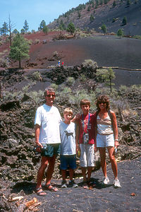
 Family Hiking Lava Flow Nature TrailOur drive down Route 89 towards Sedona brought us right past Sunset Crater Volcano National Monument. Having never been disappointed by the places the National Park System has set aside for our enjoyment, we decided to stop and check it out.
At the Visitor Center we learned to our surprise that northern Arizona has more than 400 volcanoes, and this one is the youngest of them all, having erupted as recently as 1250. Sunset Crater is actually a volcanic cone composed of lava fragments called cinders. Around 1,000 years ago, a series of eruptions spewed debris which built up into the 1,000 foot cone you see today. The lava in the final eruption in 1250 contained oxidized iron, which covered the summit with brilliant red cinders. Since the redness of the summit looks like a permanent sunset, the volcano was named Sunset Crater.
We would have loved to hike out on the cinder cone itself, but unfortunately that has been prohibited since 1973. Instead, we had to satisfy ourselves with the 1-mile, self-guided Lava Flow Nature Trail which goes along the base of the volcano. It was pretty interesting though, and we did get a chance to see the lava flow up close.
Description
Sunset Crater Volcano National Monument is located on US 89, about 16 miles north of Flagstaff.
Sunset Crater Volcano, the youngest of more than 400 volcanoes in north-central Arizona, is a volcanic cone composed of lava fragment called cinders. It was formed in a relatively recent eruption in 1064, when a mixture of molten rock and compressed air spewed into the air, solidified, and then fell back to the earth as cinders and ash. Additional eruptions over the next 200 years built up more and more debris around the vent, resulting in the 1,000 foot cone you see today. The final eruption of Sunset Crater, which occurred around 1250, spewed out lava containing oxidized iron, causing the summit to be covered with brilliant red cinders, like a permanent "sunset."
Hiking on the cinder cone itself has been prohibited since 1973. However, the 1-mile, self-guided Lava Flow Nature Trail along the base of the volcano provides close-up views of the lava flow.
- ‹ previous
- 21 of 36
- next ›
Sunset Crater Volcano National Monument location map in "high definition"
Javascript is required to view this map.
